Search
You Searched For
Search Results
- Creator:
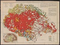
- Teleki, Pál, gróf, 1879-1941
- Published / Created:
- [1910?]
- Call Number:
- 43ed 1910
- Container / Volume:
- BRBL_00251
- Image Count:
- 1
- Resource Type:
- Maps, Atlases & Globes
- Alternative Title:
- Ethnographical map of Hungary based on the density of population
- Description:
- "Every square millimeter coloured indicates 100 inhabitants. According to the census of 1910."
- Publisher:
- Hungarian Geographical Institut,
- Subject (Geographic):
- Carpathian Mountains--Maps, Czechoslovakia--Maps, Hungary--Census, 1910--Maps, Hungary--Maps, Romania--Transylvania--Maps, Yugoslavia--Maps, and Zakarpatsʹka oblastʹ (Ukraine)--Maps
- Subject (Topic):
- Ethnology--Carpathian Mountains Region--Maps, Ethnology--Czechoslovakia--Maps, Ethnology--Hungary--Maps, Ethnology--Romania--Transylvania--Maps, Ethnology--Slovakia--Maps, and Ethnology--Ukraine--Zakarpat
- Found in:
- Beinecke Rare Book and Manuscript Library > Magyarország néprajzi térképe a népsűrűség alapján = / szerkesztette Gróf Teleki Pál = Ethnographical map of Hungary based on the density of population / by Count Paul Teleki.
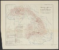
- Creator:
- Martonne, Emmanuel de, 1873-1955
- Published / Created:
- c1917.
- Call Number:
- 434cbf 1917
- Container / Volume:
- BRBL_00251
- Image Count:
- 1
- Resource Type:
- Maps, Atlases & Globes
- Description:
- From: The Geographical review, Vol. III, No. 6, 1917.
- Publisher:
- American Geographical Society of New York,
- Subject (Geographic):
- Carpathian Mountain Region--Maps and Carpathian Mountains--Maps
- Subject (Name):
- American Geographical Society of New York
- Subject (Topic):
- Geomorphology--Carpathian Mountains--Maps and Landforms--Carpathian Mountains--Maps
- Found in:
- Beinecke Rare Book and Manuscript Library > Physiographic map of the Carpathians [cartographic material] / by Emmanuel de Martonne.