Search
You Searched For
Search Results
- Creator:
- Encyclopaedia Britannica, inc
Matthews-Northrup Works
- Published / Created:
- 1918?]
- Call Number:
- 11hc 1918J
- Container / Volume:
- BRBL_00010F
- Image Count:
- 1
- Resource Type:
- Maps, Atlases & Globes
- Found in:
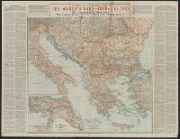
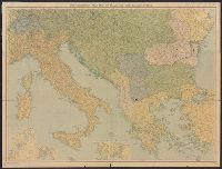
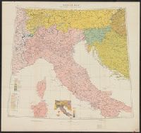
- Beinecke Rare Book and Manuscript Library > A geographical and historical guide to the world's wars, 4000 B.C. to 1918 [cartographic material] : No. 3, Showing the Italian, Balkan and Turkish Fronts / engraved and printed at the Matthews-Northrup Works, Buffalo, N.Y.
- Creator:
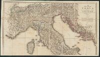
- Wyld, James, 1812-1887, cartographer
- Call Number:
- 40 1845B
- Container / Volume:
- BRBL_00200
- Image Count:
- 2
- Resource Type:
- Maps, Atlases & Globes
- Found in:
- Beinecke Rare Book and Manuscript Library > A new map of Italy, including the southern parts of Germany and the kingdom of Illyria : distinguishing their natural features and political divisions, post roads and stations with the number of posts between each station.
- Call Number:
- 40 1845A
- Container / Volume:
- BRBL_00200
- Image Count:
- 1
- Resource Type:
- Maps, Atlases & Globes
- Found in:
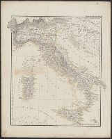
- Beinecke Rare Book and Manuscript Library > Abtheilung II. Italienische Staaten.
- Published / Created:
- 1919?]
- Call Number:
- 11hcf 1919B-29
- Container / Volume:
- BRBL_00010Q
- Image Count:
- 1
- Resource Type:
- Maps, Atlases & Globes
- Found in:
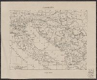
- Beinecke Rare Book and Manuscript Library > Adriatic.
- Published / Created:
- 1918
- Call Number:
- 11hc 1919XA
- Image Count:
- 2
- Resource Type:
- Maps, Atlases & Globes
- Found in:
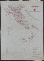
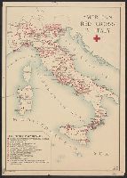
- Beinecke Rare Book and Manuscript Library > American Red Cross in Italy : Hospital and medical facilities.
- Published / Created:
- 1918
- Call Number:
- 11hc 1919XX
- Image Count:
- 1
- Resource Type:
- Maps, Atlases & Globes
- Found in:
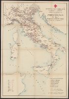
- Beinecke Rare Book and Manuscript Library > American Red Cross in Italy ; November 1917 to February 1919., Croce Rossa Americana : Dipartimento Sanitario, Novembre 1917 a Febbraio 1919 =
- Published / Created:
- 1918
- Call Number:
- 11hc 1919X
- Image Count:
- 1
- Resource Type:
- Maps, Atlases & Globes
- Found in:
- Beinecke Rare Book and Manuscript Library > American Red Cross in Italy.
- Published / Created:
- 1838
- Call Number:
- 40cah 1838
- Container / Volume:
- BRBL_00228
- Image Count:
- 4
- Resource Type:
- Maps, Atlases & Globes
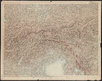
- Found in:
- Beinecke Rare Book and Manuscript Library > Atlas zu den Geologischen Beobachtungen über die vulkanischen Erscheinungen und Bildungen in Unter- und Mittel-Italien von H. Abich. Erste lieferung.
- Creator:
- John Bartholomew & Co
- Published / Created:
- [1915?]
- Call Number:
- 308 1915A
- Container / Volume:
- BRBL_00037
- Image Count:
- 2
- Resource Type:
- Maps, Atlases & Globes
- Found in:
- Beinecke Rare Book and Manuscript Library > Bartholomew's war map of Italy and the Balkan states / John Bartholomew & Co.
- Published / Created:
- [1918].
- Call Number:
- 11hcf 1919D-7
- Image Count:
- 1
- Resource Type:
- Maps, Atlases & Globes
- Found in:
- Beinecke Rare Book and Manuscript Library > Canale del Brenta.
- Published / Created:
- 1879
- Call Number:
- 40 R66 1879
- Container / Volume:
- BRBL_00218
- Image Count:
- 8
- Resource Type:
- Maps, Atlases & Globes
- Found in:
- Beinecke Rare Book and Manuscript Library > Carta Topografica dell'agro Romano Territori Limitrofi.
- Published / Created:
- [1870?]
- Call Number:
- 404 1870
- Container / Volume:
- BRBL_00235
- Image Count:
- 1
- Resource Type:
- Maps, Atlases & Globes
- Found in:
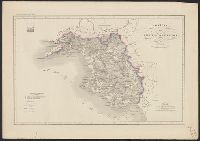
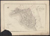
- Beinecke Rare Book and Manuscript Library > Carta corografica dell'Emilia : Provincie di Reggio d'Emilia, Modena, Bologna, Ravenna e Forlì con gran parte delle limitrofe di Firenze e Ferrara / Geometra Enrico Bonatti, dis. ; P. Allodi e filgio inc.
- Published / Created:
- [1870?]
- Call Number:
- 404 1870
- Container / Volume:
- BRBL_00235
- Image Count:
- 1
- Resource Type:
- Maps, Atlases & Globes
- Found in:
- Beinecke Rare Book and Manuscript Library > Carta corografica dell'Emilia : Provincie di Reggio d'Emilia, Modena, Bologna, Ravenna e Forlì con gran parte delle limitrofe di Firenze e Ferrara / Geometra Enrico Bonatti, dis. ; P. Allodi e filgio inc.
- Published / Created:
- ca. 1860?]
- Call Number:
- 40 1858
- Container / Volume:
- BRBL_00201
- Image Count:
- 8
- Resource Type:
- Maps, Atlases & Globes
- Found in:
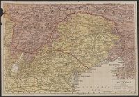
- Beinecke Rare Book and Manuscript Library > Carta corografica strategica dell' alta Italia alla scala di 1 a 600000.
- Published / Created:
- [1850?]
- Call Number:
- 400 1850
- Container / Volume:
- BRBL_00233
- Image Count:
- 1
- Resource Type:
- Maps, Atlases & Globes
- Found in:
- Beinecke Rare Book and Manuscript Library > Carta dell' Italia antica / G. Bonatti diso. ed incise. Torino.
- Published / Created:
- [1918].
- Call Number:
- 11hcf 1919D-27
- Container / Volume:
- BRBL_00010X
- Image Count:
- 1
- Resource Type:
- Maps, Atlases & Globes
- Found in:
- Beinecke Rare Book and Manuscript Library > Carta della Zona di Guerra.
- Published / Created:
- 1865
- Call Number:
- 401 1865
- Container / Volume:
- BRBL_00233
- Image Count:
- 1
- Resource Type:
- Maps, Atlases & Globes
- Found in:
- Beinecke Rare Book and Manuscript Library > Carta delle provincie di Torino, Cuneo, Novara, Alessandria e Pavia.
- Published / Created:
- [ca. 1920].
- Call Number:
- 40gme 1920
- Container / Volume:
- BRBL_00230
- Image Count:
- 2
- Resource Type:
- Maps, Atlases & Globes
- Found in:
- Beinecke Rare Book and Manuscript Library > Carta ferroviaria d'Italia e linee di navigazione / Prof. Giovanni de Agostini e figli.
- Published / Created:
- [1910?]
- Call Number:
- 40gm 1910
- Container / Volume:
- BRBL_00229
- Image Count:
- 2
- Resource Type:
- Maps, Atlases & Globes
- Found in:
- Beinecke Rare Book and Manuscript Library > Carta generale delle strade ferrate Italiane e linee di navigazione.
- Published / Created:
- [1844?]
- Call Number:
- 401 1844
- Container / Volume:
- BRBL_00233
- Image Count:
- 1
- Resource Type:
- Maps, Atlases & Globes
- Found in:
- Beinecke Rare Book and Manuscript Library > Carta moderna degli State Sarde di Terraferma [cartographic material] / V. Stanghi e G. Maina Inc. ; G Pozzi scrisse.
- Published / Created:
- [1860]
- Call Number:
- 40 Sv39 1860A
- Image Count:
- 1
- Resource Type:
- Maps, Atlases & Globes
- Found in:
- Beinecke Rare Book and Manuscript Library > Carta orografica e idrografica della Svizzera Italiana.
- Published / Created:
- [1860]
- Call Number:
- 40 Sv39 1860
- Image Count:
- 1
- Resource Type:
- Maps, Atlases & Globes
- Found in:
- Beinecke Rare Book and Manuscript Library > Carta orografica e idrografica della Svizzera Italiana.
- Published / Created:
- [1860]
- Call Number:
- 40 Sv39 1860
- Image Count:
- 1
- Resource Type:
- Maps, Atlases & Globes
- Found in:
- Beinecke Rare Book and Manuscript Library > Carta orografica e idrografica della Svizzera Italiana.
- Published / Created:
- [1860]
- Call Number:
- 40 Sv39 1860
- Image Count:
- 1
- Resource Type:
- Maps, Atlases & Globes
- Found in:
- Beinecke Rare Book and Manuscript Library > Carta orografica e idrografica della Svizzera Italiana.
- Published / Created:
- [1860]
- Call Number:
- 40 Sv39 1860A
- Image Count:
- 1
- Resource Type:
- Maps, Atlases & Globes
- Found in:
- Beinecke Rare Book and Manuscript Library > Carta orografica e idrografica della Svizzera Italiana.
- Published / Created:
- 1859
- Call Number:
- 401 1859
- Container / Volume:
- BRBL_00233
- Image Count:
- 1
- Resource Type:
- Maps, Atlases & Globes
- Found in:
- Beinecke Rare Book and Manuscript Library > Carta politico-amministativa degli State Sarde di Terraferma / V. Stanghi e G. Maina Inc. ; G Pozzi scrisse.
- Published / Created:
- 1838
- Call Number:
- 40 1838A
- Container / Volume:
- BRBL_00200
- Image Count:
- 1
- Resource Type:
- Maps, Atlases & Globes
- Found in:
- Beinecke Rare Book and Manuscript Library > Carta postale ed itineraria dell'Italia / dedicata al Nobe. Sigr. Cavaliere Massinilia no Otto de Ottenfeld I.R. Effettivo Consigliere Aulico ; da A.F. Botte I.R. Consigle. e Diretteure delle Poste nelle Prove. Venete, compilatore ed Editore ; prem. lit.
- Published / Created:
- 1857
- Call Number:
- 40 1857
- Container / Volume:
- BRBL_00200
- Image Count:
- 1
- Resource Type:
- Maps, Atlases & Globes
- Found in:
- Beinecke Rare Book and Manuscript Library > Carta stradale dell' Italia : disegnata ed incisa dietro le carte piu recenti ed accreditate / da Pietro Allodi ; Giberto Morandotti impr.
- Published / Created:
- 1859
- Call Number:
- 40 1859A
- Container / Volume:
- BRBL_00201
- Image Count:
- 1
- Resource Type:
- Maps, Atlases & Globes
- Found in:
- Beinecke Rare Book and Manuscript Library > Carta stradale e postale dell'Italia / Carlo Cerri.
- Published / Created:
- 1848
- Call Number:
- 40hc 1848
- Container / Volume:
- BRBL_00231
- Image Count:
- 1
- Resource Type:
- Maps, Atlases & Globes
- Found in:
- Beinecke Rare Book and Manuscript Library > Carta topografica della guerra dell'Anno 1848.
- Published / Created:
- [1859?]
- Call Number:
- 40hc 1859D
- Container / Volume:
- BRBL_00231
- Image Count:
- 1
- Resource Type:
- Maps, Atlases & Globes
- Found in:
- Beinecke Rare Book and Manuscript Library > Carte a vol d'oiseau pour suivre les Opérations stratégiques dans L'Italie Septentrionale.
- Published / Created:
- 1859
- Call Number:
- 40 1859E
- Container / Volume:
- BRBL_00201
- Image Count:
- 1
- Resource Type:
- Maps, Atlases & Globes
- Found in:
- Beinecke Rare Book and Manuscript Library > Carte de la Haute Italie et de L'Italie Centrale / par L. Sagansan, géographe de S.M. L'Empereur.
- Published / Created:
- 1859
- Call Number:
- 40hc 1859H
- Container / Volume:
- BRBL_00231
- Image Count:
- 1
- Resource Type:
- Maps, Atlases & Globes
- Found in:
- Beinecke Rare Book and Manuscript Library > Carte en relief du théâtre de la guerre en Italie des frontières de la France a L'Adriatique indiquant les Villes, Fortifications & voies ferrées : Comprises dan tout le pays occupé par les troupes Franc̥aises, Sardes et Autrichiennes.
- Published / Created:
- [1846?]
- Call Number:
- 40 1846
- Container / Volume:
- BRBL_00200
- Image Count:
- 1
- Resource Type:
- Maps, Atlases & Globes
- Found in:
- Beinecke Rare Book and Manuscript Library > Carte routière d'Italie / dressée et gravée par Amboise Tardieu ...
- Published / Created:
- 1845
- Call Number:
- 40 1845D
- Container / Volume:
- BRBL_00200
- Image Count:
- 1
- Resource Type:
- Maps, Atlases & Globes
- Found in:
- Beinecke Rare Book and Manuscript Library > Carte routière d'Italie / dressée et gravée par Amboise Tardieu ...
- Published / Created:
- 1824
- Call Number:
- 40 1824
- Container / Volume:
- BRBL_00199
- Image Count:
- 1
- Resource Type:
- Maps, Atlases & Globes
- Found in:
- Beinecke Rare Book and Manuscript Library > Carte routiére de l'Italy ... / par A.H. Brue ...
- Published / Created:
- 1873
- Call Number:
- 40 1873
- Container / Volume:
- BRBL_00202
- Image Count:
- 2
- Resource Type:
- Maps, Atlases & Globes
- Found in:
- Beinecke Rare Book and Manuscript Library > Central and South Italy : to accompany the handbooks for travellers / by J. & C. Walker.
- Published / Created:
- [1859?]
- Call Number:
- 40hc 1859C
- Container / Volume:
- BRBL_00231
- Image Count:
- 1
- Resource Type:
- Maps, Atlases & Globes
- Found in:
- Beinecke Rare Book and Manuscript Library > Champ de Bataille de L'Italie.
- Published / Created:
- 1807
- Call Number:
- 40 1807
- Container / Volume:
- BRBL_00199
- Image Count:
- 1
- Resource Type:
- Maps, Atlases & Globes
- Found in:
- Beinecke Rare Book and Manuscript Library > Charte von Italien und Dalmatien ... / von Conrad Mannert.
- Published / Created:
- [1822?]
- Call Number:
- 40 1822
- Container / Volume:
- BRBL_00199
- Image Count:
- 1
- Resource Type:
- Maps, Atlases & Globes
- Found in:
- Beinecke Rare Book and Manuscript Library > Die Halbinsel Italien ... / gez. v. Schlieben ; gest. v. A.G. Mossner Nbg.
- Published / Created:
- [1800?]
- Call Number:
- 40 1800C
- Container / Volume:
- BRBL_00199
- Image Count:
- 1
- Resource Type:
- Maps, Atlases & Globes
- Found in:
- Beinecke Rare Book and Manuscript Library > Die Halbinsel Italien ... / gez. v. Schlieben ; gest. v. A.G. Mossner Nbg.
- Published / Created:
- [1918?]
- Call Number:
- 53 1918
- Container / Volume:
- BRBL_00285
- Image Count:
- 1
- Resource Type:
- Maps, Atlases & Globes
- Found in:
- Beinecke Rare Book and Manuscript Library > Etats Balkaniques / L. Bergelin, Cartographe.
- Published / Created:
- 1802
- Call Number:
- 40 1802B
- Container / Volume:
- BRBL_00199
- Image Count:
- 1
- Resource Type:
- Maps, Atlases & Globes
- Found in:
- Beinecke Rare Book and Manuscript Library > General-Charte von Italien ...
- Creator:
- C.S. Hammond & Company
- Published / Created:
- [1918]
- Call Number:
- 11hc 1918Z-6
- Container / Volume:
- BRBL_00010H
- Image Count:
- 2
- Resource Type:
- Maps, Atlases & Globes
- Found in:
- Beinecke Rare Book and Manuscript Library > Hammond's large scale war map of the Western Front ; Hammond's large scale war map Italian Front [cartographic material].
- Creator:
- Austro-Hungarian Monarchy. Heer. Generalstab, cartographer
- Published / Created:
- [between 1880 and 1899?]
- Call Number:
- 40CBF 1887
- Container / Volume:
- BRBL_00228
- Image Count:
- 1
- Resource Type:
- Maps, Atlases & Globes
- Found in:
- Beinecke Rare Book and Manuscript Library > Hypsometrische Karte von Mittel-Italien, im Masse 1/750000 / entworfen u. gezeichnet im Landesbeschreibungs Bureau des K. K. Generalstabes.
- Published / Created:
- 1809
- Call Number:
- 40hc 1809
- Container / Volume:
- BRBL_00231
- Image Count:
- 1
- Resource Type:
- Maps, Atlases & Globes
- Found in:
- Beinecke Rare Book and Manuscript Library > Il Teatro della Guerra, 1809, in Milano.
- Published / Created:
- [1905?]
- Call Number:
- 40 1905
- Container / Volume:
- BRBL_00202
- Image Count:
- 1
- Resource Type:
- Maps, Atlases & Globes
- Found in:
- Beinecke Rare Book and Manuscript Library > Italia / G. Galli.
- Published / Created:
- 1891
- Call Number:
- 40 1891A
- Container / Volume:
- BRBL_00202
- Image Count:
- 1
- Resource Type:
- Maps, Atlases & Globes
- Found in:
- Beinecke Rare Book and Manuscript Library > Italien / bearbeitet von C. Vogel.
- Creator:
- Vogel, C. (Carl), 1828-1897
- Published / Created:
- 1891
- Call Number:
- 40 1891
- Container / Volume:
- BRBL_00202
- Image Count:
- 1
- Resource Type:
- Maps, Atlases & Globes
- Found in:
- Beinecke Rare Book and Manuscript Library > Italien in 4 Blättern / von C. Vogel ; berichtigt von O. Koffmahn ; gest. v. Kühn, Kern u. Weiler.
- Published / Created:
- 1814
- Call Number:
- 40 1814
- Container / Volume:
- BRBL_00199
- Image Count:
- 1
- Resource Type:
- Maps, Atlases & Globes
- Found in:
- Beinecke Rare Book and Manuscript Library > Italy / R. Scott sculpt.
- Creator:
- United States. Office of Strategic Services. Research and Analysis Branch
- Published / Created:
- 1943
- Call Number:
- 40gfb 1943
- Container / Volume:
- BRBL_00229
- Image Count:
- 1
- Resource Type:
- Maps, Atlases & Globes
- Found in:
- Beinecke Rare Book and Manuscript Library > Italy Chemical Industry: Location of principal plants / James H. Shoemaker Lt. Col.
- Creator:
- United States. Office of Strategic Services. Research and Analysis Branch
- Published / Created:
- 1945
- Call Number:
- 40fb 1945
- Container / Volume:
- BRBL_00229
- Image Count:
- 1
- Resource Type:
- Maps, Atlases & Globes
- Found in:
- Beinecke Rare Book and Manuscript Library > Italy [cartographic material].
- Creator:
- Carey, Mathew, 1760-1839
- Published / Created:
- 1814]
- Call Number:
- 40 1795A
- Container / Volume:
- BRBL_00198
- Image Count:
- 1
- Resource Type:
- Maps, Atlases & Globes
- Found in:
- Beinecke Rare Book and Manuscript Library > Italy and Sardinia, from the best authorities / [engraved by] Bower.
- Published / Created:
- 1800
- Call Number:
- 40 1800
- Container / Volume:
- BRBL_00199
- Image Count:
- 2
- Resource Type:
- Maps, Atlases & Globes
- Found in:
- Beinecke Rare Book and Manuscript Library > Italy with the addition of the southern parts of Germany ... / by L.S. Delarochette.
- Published / Created:
- 191-.
- Call Number:
- 11hcf 1919D-25
- Container / Volume:
- BRBL_00010W
- Image Count:
- 1
- Resource Type:
- Maps, Atlases & Globes
- Found in:
- Beinecke Rare Book and Manuscript Library > Italy.
- Creator:
- Ordnance Survey of Great Britain and Ireland
Royal Geographical Society (Great Britain). Geographical Section
- Published / Created:
- 1915
- Call Number:
- 11hcf 1919E-18
- Container / Volume:
- BRBL_00010Z
- Image Count:
- 1
- Resource Type:
- Maps, Atlases & Globes
- Found in:
- Beinecke Rare Book and Manuscript Library > Jitomir : North M 35. / compiled at the Royal Geographical Society under the direction of the Geographical Section; drawn and printed by Ordnance Survey.
- Creator:
- Ordnance Survey of Great Britain and Ireland
Royal Geographical Society (Great Britain). Geographical Section
- Published / Created:
- 1915
- Call Number:
- 11hcf 1919E-18
- Image Count:
- 1
- Resource Type:
- Maps, Atlases & Globes
- Found in:
- Beinecke Rare Book and Manuscript Library > Jitomir : North M 35. / compiled at the Royal Geographical Society under the direction of the Geographical Section; drawn and printed by Ordnance Survey.
- Creator:
- Johnson, A. J. (Alvin Jewett), 1827-1884
- Published / Created:
- [1866]
- Call Number:
- 40 1866
- Container / Volume:
- BRBL_00202
- Image Count:
- 2
- Resource Type:
- Maps, Atlases & Globes
- Found in:
- Beinecke Rare Book and Manuscript Library > Johnson's Italy [cartographic material].
- Call Number:
- 40 1839
- Container / Volume:
- BRBL_00200
- Image Count:
- 2
- Resource Type:
- Maps, Atlases & Globes
- Found in:
- Beinecke Rare Book and Manuscript Library > Karte von Italien, nebst den nördlich angraenzenden Laendern : zum Hand und Reisegebrauche / im Stein gest. ... v. W. Pobuda.
- Published / Created:
- 191-.
- Call Number:
- 11hcf 1919A-11
- Container / Volume:
- BRBL_00010M
- Image Count:
- 1
- Resource Type:
- Maps, Atlases & Globes
- Found in:
- Beinecke Rare Book and Manuscript Library > La Regione Veneta e le Alpi Nostre : dalle fonti dell'Adige al Quarnaro, Carta etnico-linguistica pubblicata dall'Istituto Geografico De Agostini.
- Published / Created:
- 1918?]
- Call Number:
- 11hc 1918Z-1
- Container / Volume:
- BRBL_00010F
- Image Count:
- 1
- Resource Type:
- Maps, Atlases & Globes
- Found in:
- Beinecke Rare Book and Manuscript Library > Linea d'Armistizio : Villa Giusti - 3 Novembre 1918.
- Published / Created:
- 191-.
- Call Number:
- 11hcf 1919-36
- Container / Volume:
- BRBL_00010K
- Image Count:
- 1
- Resource Type:
- Maps, Atlases & Globes
- Found in:
- Beinecke Rare Book and Manuscript Library > Linguistic map of Venezia Tridentia, Venezia Giulia and Dalmatia.
- Published / Created:
- [between 1840 and 1849?]
- Call Number:
- BrSides 2018 158
- Image Count:
- 1
- Resource Type:
- Maps, Atlases & Globes
- Found in:
- Beinecke Rare Book and Manuscript Library > Lo e Alpi in Italia.
- Creator:
- Ettling, Theodor, b. 1823
- Published / Created:
- 1860
- Call Number:
- 40 1860
- Container / Volume:
- BRBL_00201
- Image Count:
- 1
- Resource Type:
- Maps, Atlases & Globes
- Found in:
- Beinecke Rare Book and Manuscript Library > Map of Italy and Switzerland [cartographic material] / by T. Ettling.
- Creator:
- Ordnance Survey of Great Britain and Ireland
Royal Geographical Society (Great Britain). Geographical Section
- Published / Created:
- [1914?]
- Call Number:
- 11hcf 1919E-17
- Image Count:
- 1
- Resource Type:
- Maps, Atlases & Globes
- Found in:
- Beinecke Rare Book and Manuscript Library > Milano : North L. 32. / compiled at the Royal Geographical Society under the direction of the Geographical Section; drawn and printed by Ordnance Survey.
- Creator:
- Royal Geographical Society (Great Britain). Geographical Section, cartographer
- Call Number:
- 11hcf 1919E-23
- Container / Volume:
- BRBL_00010ZA
- Image Count:
- 1
- Resource Type:
- Maps, Atlases & Globes
- Found in:
- Beinecke Rare Book and Manuscript Library > Milano [cartographic material] : North L. 32. / compiled at the Royal Geographical Society under the direction of the Geographical Section; drawn and printed by Ordnance Survey.
- Creator:
- Great Britain. War Office. General Staff. Geographical Section
- Published / Created:
- 1918
- Call Number:
- 11hcf 1919D-6
- Image Count:
- 1
- Resource Type:
- Maps, Atlases & Globes
- Found in:
- Beinecke Rare Book and Manuscript Library > Northern Italy ethnographical map [cartographic material].
- Creator:
- Great Britain. War Office. General Staff. Geographical Section
- Published / Created:
- 1918
- Call Number:
- 40ed 1918
- Container / Volume:
- BRBL_00229
- Image Count:
- 1
- Resource Type:
- Maps, Atlases & Globes
- Found in:
- Beinecke Rare Book and Manuscript Library > Northern Italy ethnographical map [cartographic material].
- Published / Created:
- 1802
- Call Number:
- 40 1802A
- Container / Volume:
- BRBL_00199
- Image Count:
- 2
- Resource Type:
- Maps, Atlases & Globes
- Found in:
- Beinecke Rare Book and Manuscript Library > Nuova carta dell' Italia ... / Gius Guerra inc. Nap.
- Published / Created:
- 191-?]
- Call Number:
- 11hcf 1919D-11
- Container / Volume:
- BRBL_00010W
- Image Count:
- 1
- Resource Type:
- Maps, Atlases & Globes
- Found in:
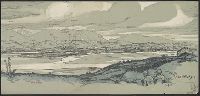
- Beinecke Rare Book and Manuscript Library > Panorama Castelletto-Mezzaselva.
- Published / Created:
- 191-?]
- Call Number:
- 11hcf 1919D-13
- Container / Volume:
- BRBL_00010W
- Image Count:
- 1
- Resource Type:
- Maps, Atlases & Globes
- Found in:
- Beinecke Rare Book and Manuscript Library > Panorama Da M. Chiesa A M. Ortigara.
- Published / Created:
- 191-?]
- Call Number:
- 11hcf 1919D-14
- Container / Volume:
- BRBL_00010W
- Image Count:
- 1
- Resource Type:
- Maps, Atlases & Globes
- Found in:
- Beinecke Rare Book and Manuscript Library > Panorama da Monte Grappa.
- Published / Created:
- 1850?]
- Call Number:
- 40GCF 1850
- Container / Volume:
- BRBL_00229
- Image Count:
- 1
- Resource Type:
- Maps, Atlases & Globes
- Found in:
- Beinecke Rare Book and Manuscript Library > Profilo della livellazione ossia pendenza del cavo antico del redefossi dal travacatore a porta tosa, sino alla vecchiabbia / Mare Anto. dal Re Sei.
- Published / Created:
- [1840?]
- Call Number:
- 40 P935 1840
- Container / Volume:
- BRBL_00215
- Image Count:
- 1
- Resource Type:
- Maps, Atlases & Globes
- Found in:
- Beinecke Rare Book and Manuscript Library > Provincia di Principato citeriore.
- Published / Created:
- [1840?]
- Call Number:
- 40 P935 1840
- Container / Volume:
- BRBL_00215
- Image Count:
- 1
- Resource Type:
- Maps, Atlases & Globes
- Found in:
- Beinecke Rare Book and Manuscript Library > Provincia di Principato citeriore.
- Published / Created:
- [1840?]
- Call Number:
- 40 P935 1840
- Container / Volume:
- BRBL_00215
- Image Count:
- 1
- Resource Type:
- Maps, Atlases & Globes
- Found in:
- Beinecke Rare Book and Manuscript Library > Provincia di Principato citeriore.
- Creator:
- Rand McNally and Company
- Published / Created:
- [1917?]
- Call Number:
- 40hc 1914
- Container / Volume:
- BRBL_00232
- Image Count:
- 4
- Resource Type:
- Maps, Atlases & Globes
- Found in:
- Beinecke Rare Book and Manuscript Library > Rand McNally war map of the Italian front [cartographic material] : northern section : strategic map of the battle ground in northern Italy from Swiss border to Adriatic Sea / compiled from the latest military maps of the army staffs in Washington, London
- Creator:
- Ordnance Survey of Great Britain and Ireland
Royal Geographical Society (Great Britain). Geographical Section
- Published / Created:
- 1916
- Call Number:
- 11hcf 1919E-16
- Image Count:
- 1
- Resource Type:
- Maps, Atlases & Globes
- Found in:
- Beinecke Rare Book and Manuscript Library > Roma : North K 33. / compiled at the Royal Geographical Society under the direction of the Geographical Section; drawn and printed by Ordnance Survey.
- Published / Created:
- 1943
- Call Number:
- 409gm 1943
- Container / Volume:
- BRBL_00240
- Image Count:
- 1
- Resource Type:
- Maps, Atlases & Globes
- Found in:
- Beinecke Rare Book and Manuscript Library > Sardinia: Special strategic map [cartographic material].
- Published / Created:
- 1861
- Call Number:
- 40gme 1861
- Container / Volume:
- BRBL_00230
- Image Count:
- 1
- Resource Type:
- Maps, Atlases & Globes
- Found in:
- Beinecke Rare Book and Manuscript Library > Strade Ferrate : Merid. dello Stato, Lombo., Venete e dell'Italia Centrale.
- Published / Created:
- 1848
- Call Number:
- 40hc G166 1848
- Container / Volume:
- BRBL_00232
- Image Count:
- 1
- Resource Type:
- Maps, Atlases & Globes
- Found in:
- Beinecke Rare Book and Manuscript Library > Teatro della guerra in Italia 1848. Corografia del Lago di Garda e suoi contorni comprese le Citta di Mantova, Brescia, Verona, Reveredo e Trento.
- Creator:
- Rand McNally and Company
- Published / Created:
- 1914
- Call Number:
- 40 1914A
- Container / Volume:
- BRBL_00202
- Image Count:
- 2
- Resource Type:
- Maps, Atlases & Globes
- Found in:
- Beinecke Rare Book and Manuscript Library > The Rand-McNally new library atlas map of Italy [cartographic material].
- Published / Created:
- 1874
- Call Number:
- 40 1874
- Container / Volume:
- BRBL_00202
- Image Count:
- 1
- Resource Type:
- Maps, Atlases & Globes
- Found in:
- Beinecke Rare Book and Manuscript Library > The states of Italy, with their islands, Corsica, Sardinia, Sicily & Malta ...
- Published / Created:
- [1918].
- Call Number:
- 11hcf 1919D-10
- Container / Volume:
- BRBL_00010W
- Image Count:
- 1
- Resource Type:
- Maps, Atlases & Globes
- Found in:
- Beinecke Rare Book and Manuscript Library > Trentino Occidentale.
- Creator:
- Ordnance Survey of Great Britain and Ireland
Royal Geographical Society (Great Britain). Geographical Section
- Published / Created:
- 1915
- Call Number:
- 11hcf 1919E-11
- Image Count:
- 1
- Resource Type:
- Maps, Atlases & Globes
- Found in:
- Beinecke Rare Book and Manuscript Library > Triest : North L 33. / compiled at the Royal Geographical Society under the direction of the Geographical Section; drawn and printed by Ordnance Survey.
- Creator:
- Ordnance Survey of Great Britain and Ireland
Royal Geographical Society (Great Britain). Geographical Section
- Published / Created:
- 1915
- Call Number:
- 11hcf 1919E-10
- Container / Volume:
- BRBL_00010Z
- Image Count:
- 1
- Resource Type:
- Maps, Atlases & Globes
- Found in:
- Beinecke Rare Book and Manuscript Library > Triest : North L 33. / compiled at the Royal Geographical Society under the direction of the Geographical Section; drawn and printed by Ordnance Survey.
- Creator:
- Ordnance Survey of Great Britain and Ireland
Royal Geographical Society (Great Britain). Geographical Section
- Published / Created:
- 1915
- Call Number:
- 11hcf 1919E-10
- Image Count:
- 1
- Resource Type:
- Maps, Atlases & Globes
- Found in:
- Beinecke Rare Book and Manuscript Library > Triest : North L 33. / compiled at the Royal Geographical Society under the direction of the Geographical Section; drawn and printed by Ordnance Survey.
- Published / Created:
- 1859
- Call Number:
- 40hc 1859G
- Container / Volume:
- BRBL_00231
- Image Count:
- 1
- Resource Type:
- Maps, Atlases & Globes
- Found in:
- Beinecke Rare Book and Manuscript Library > Vue panoramique de L'Autriche & de L'Italie : Théâtre de la Guerre / Dessinée et Lithographièe par L. Lebreton.
- Published / Created:
- 1919?]
- Call Number:
- 11hcf 1919B-30
- Container / Volume:
- BRBL_00010Q
- Image Count:
- 1
- Resource Type:
- Maps, Atlases & Globes
- Found in:
- Beinecke Rare Book and Manuscript Library > [Coast of the Adriatic Sea].
- Published / Created:
- 1918
- Call Number:
- 11hcf 1919D-16
- Container / Volume:
- BRBL_00010W
- Image Count:
- 1
- Resource Type:
- Maps, Atlases & Globes
- Found in:
- Beinecke Rare Book and Manuscript Library > [Da Croda della Spia.]
- Published / Created:
- 191-?]
- Call Number:
- 11hcf 1919D-17
- Container / Volume:
- BRBL_00010W
- Image Count:
- 1
- Resource Type:
- Maps, Atlases & Globes
- Found in:
- Beinecke Rare Book and Manuscript Library > [Fiume].
- Published / Created:
- 191-.
- Call Number:
- 11hcf 1919A-31
- Container / Volume:
- BRBL_00010N
- Image Count:
- 2
- Resource Type:
- Maps, Atlases & Globes
- Found in:
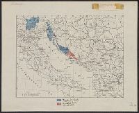
- Beinecke Rare Book and Manuscript Library > [Italian claims along the Adriatic Sea.]
- Published / Created:
- [1915?]
- Call Number:
- 40gme 1915
- Container / Volume:
- BRBL_00230
- Image Count:
- 2
- Resource Type:
- Maps, Atlases & Globes
- Found in:
- Beinecke Rare Book and Manuscript Library > [Italy].
- Published / Created:
- 1918?]
- Call Number:
- 11hc 1918Z-2
- Container / Volume:
- BRBL_00010G
- Image Count:
- 1
- Resource Type:
- Maps, Atlases & Globes
- Found in:
- Beinecke Rare Book and Manuscript Library > [Linea d'Armistizio : Villa Giusti, 3 Novembre 1918].
- Published / Created:
- [1917].
- Call Number:
- 11hcf 1919D-28
- Container / Volume:
- BRBL_00010X
- Image Count:
- 2
- Resource Type:
- Maps, Atlases & Globes
- Found in:
- Beinecke Rare Book and Manuscript Library > [Map of Italy and surrounding region during World War I.]
- Published / Created:
- [19--?]
- Call Number:
- 40gme 1865
- Container / Volume:
- BRBL_00230
- Image Count:
- 2
- Resource Type:
- Maps, Atlases & Globes
- Found in:
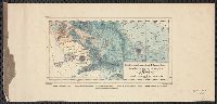
- Beinecke Rare Book and Manuscript Library > [Map of the railways of Italy].
- Published / Created:
- 1919
- Call Number:
- 11hcf 1919E-3
- Container / Volume:
- BRBL_00010ZA
- Image Count:
- 1
- Resource Type:
- Maps, Atlases & Globes
- Found in:
- Beinecke Rare Book and Manuscript Library > [Map showing the Trieste-Isonzo region, including Fiume.]
- Published / Created:
- [1915?]
- Call Number:
- 11hcf 1919A-32
- Container / Volume:
- BRBL_00010N
- Image Count:
- 1
- Resource Type:
- Maps, Atlases & Globes
- Found in:
- Beinecke Rare Book and Manuscript Library > [Regional map of the area around the Adriatic Sea : showing the cities of Pola, Zara, Comacchio] / K.u.K. Militärgeographisches Institut.