Search
You Searched For
Search Results
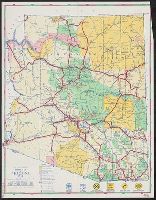
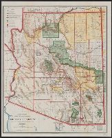
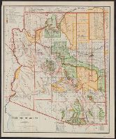
- Creator:
- DeMerse, W. M
- Published / Created:
- [1942]
- Call Number:
- 842gmb 1942
- Container / Volume:
- BRBL_00600
- Image Count:
- 2
- Resource Type:
- Maps, Atlases & Globes
- Alternative Title:
- Arizona, road map, 1942, Map of western United States, showing U.S. highway system., and State Highway Department, road map of Arizona, 1942
- Description:
- "Map of western United States, showing U.S. highway system," distance table, ill., index, and text on verso.
- Publisher:
- Arizona State Highway Commission,
- Subject (Geographic):
- Arizona--Administrative and political divisions--Maps and Arizona--Maps
- Subject (Name):
- Arizona. State Highway Commission
- Subject (Topic):
- Express highways--West (U.S.)--Maps, Forest reserves--Arizona--Maps, Indian reservations--Arizona--Maps, and Roads--Arizona--Maps
- Found in:
- Beinecke Rare Book and Manuscript Library > Road map of Arizona, 1942 / compiled and drawn by W.M. DeMerse.
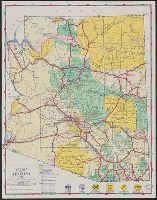
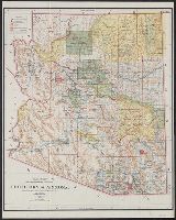
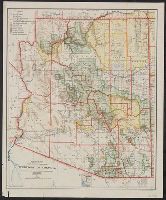
- Creator:
- Arizona. State Highway Commission
- Published / Created:
- 1946]
- Call Number:
- 842gmb 1946
- Container / Volume:
- BRBL_00600
- Image Count:
- 1
- Resource Type:
- Maps, Atlases & Globes
- Alternative Title:
- State Highway Department, road map of Arizona, 1946
- Description:
- Also shows counties, national forests, and Indian reservations.
- Publisher:
- The Commission?,
- Subject (Geographic):
- Arizona--Administrative and political divisions--Maps and Arizona--Maps
- Subject (Topic):
- Forest reserves--Arizona--Maps, Indian reservations--Arizona--Maps, and Roads--Arizona--Maps
- Found in:
- Beinecke Rare Book and Manuscript Library > Road map of Arizona, 1946 / Arizona State Highway Commission.
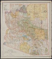
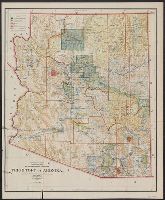
- Creator:
- United States. General Land Office
- Published / Created:
- 1933
- Call Number:
- 842 1933
- Container / Volume:
- BRBL_00599
- Image Count:
- 1
- Resource Type:
- Maps, Atlases & Globes
- Description:
- Relief shown by shading, hachures, and spot heights.
- Publisher:
- U.S. Dept. of the Interior, General Land Office,
- Subject (Geographic):
- Arizona--Administrative and political divisions--Maps
- Subject (Name):
- Gales, T. W
- Subject (Topic):
- Forest reserves--Arizona--Maps and Indian reservations--Arizona--Maps
- Found in:
- Beinecke Rare Book and Manuscript Library > State of Arizona / compiled from the official records of the General Land Office and other sources ; compiled and drawn by T.W. Gales.
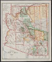
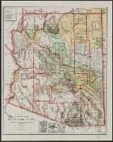
- Creator:
- O'Hare, Daniel
- Published / Created:
- 1906
- Call Number:
- 842 1906
- Container / Volume:
- BRBL_00599
- Image Count:
- 1
- Resource Type:
- Maps, Atlases & Globes
- Description:
- Includes inset of the Sonora railway and township diagram showing sections and quarter-sections.
- Publisher:
- General Land Office,
- Subject (Geographic):
- Arizona--Administrative and political divisions--Maps and Arizona--Maps
- Subject (Name):
- Bond, Frank, 1856-1940, Norris Peters Co, and United States. General Land Office
- Subject (Topic):
- Forest reserves--Arizona--Maps and Indian reservations--Arizona--Maps
- Found in:
- Beinecke Rare Book and Manuscript Library > Territory of Arizona / compiled from the official records of the General Land Office and other sources under the direction of Frank Bond ; compiled and drawn by Daniel O'Hare.
- Creator:
- O'Hare, Daniel
- Published / Created:
- 1903
- Call Number:
- 842 1903A
- Container / Volume:
- BRBL_00599
- Image Count:
- 1
- Resource Type:
- Maps, Atlases & Globes
- Description:
- Includes inset of the Sonora railway and township diagram.
- Publisher:
- The Office,
- Subject (Geographic):
- Arizona--Administrative and political divisions--Maps and Arizona--Maps
- Subject (Name):
- Bond, Frank, 1856-1940 and United States. General Land Office
- Subject (Topic):
- Forest reserves--Arizona--Maps and Indian reservations--Arizona--Maps
- Found in:
- Beinecke Rare Book and Manuscript Library > Territory of Arizona / compiled from the official records of the General Land Office and other sources under the direction of Frank Bond ; compiled and drawn by Daniel O'Hare.
- Creator:
- United States. General Land Office
- Published / Created:
- 1901
- Call Number:
- 842 1901
- Container / Volume:
- BRBL_00599
- Image Count:
- 1
- Resource Type:
- Maps, Atlases & Globes
- Description:
- Prime meridians: Greenwich and Washington.
- Publisher:
- General Land Office,
- Subject (Geographic):
- Arizona--Administrative and political divisions--Maps and Arizona--Maps
- Subject (Topic):
- Forest reserves--Arizona--Maps and Indian reservations--Arizona--Maps
- Found in:
- Beinecke Rare Book and Manuscript Library > Territory of Arizona / compiled from the official records of the General Land Office and other sources under the direction of Harry King, C.E.
- Creator:
- United States. General Land Office
- Published / Created:
- 1902
- Call Number:
- 842 1902
- Container / Volume:
- BRBL_00599
- Image Count:
- 1
- Resource Type:
- Maps, Atlases & Globes
- Description:
- Prime meridians: Greenwich and Washington.
- Publisher:
- The Office,
- Subject (Geographic):
- Arizona--Administrative and political divisions--Maps and Arizona--Maps
- Subject (Topic):
- Forest reserves--Arizona--Maps and Indian reservations--Arizona--Maps
- Found in:
- Beinecke Rare Book and Manuscript Library > Territory of Arizona / compiled from the official records of the General Land Office and other sources under the direction of Harry King, C.E.
- Creator:
- O'Hare, Daniel
- Published / Created:
- 1910
- Call Number:
- 842 1910A
- Container / Volume:
- BRBL_00599
- Image Count:
- 1
- Resource Type:
- Maps, Atlases & Globes
- Description:
- "Printed by the U.S. Geological Survey."
- Publisher:
- General Land Office,
- Subject (Geographic):
- Arizona--Administrative and political divisions--Maps and Arizona--Maps
- Subject (Name):
- Bauman, Wm. (William), Berthrong, I. P, and United States. General Land Office
- Subject (Topic):
- Forest reserves--Arizona--Maps and Indian reservations--Arizona--Maps
- Found in:
- Beinecke Rare Book and Manuscript Library > Territory of Arizona / compiled from the official records of the General Land Office and other sources under the direction of I.P. Berthrong ; compiled and drawn by Daniel O'Hare ; lettering by Wm. Bauman.
- Creator:
- O'Hare, Daniel
- Published / Created:
- 1907
- Call Number:
- 842 1907A
- Container / Volume:
- BRBL_00599
- Image Count:
- 1
- Resource Type:
- Maps, Atlases & Globes
- Description:
- "Norris Peters Co., photo-litho."
- Publisher:
- General Land Office,
- Subject (Geographic):
- Arizona--Administrative and political divisions--Maps and Arizona--Maps
- Subject (Name):
- Berthrong, I. P, Norris Peters Co, and United States. General Land Office
- Subject (Topic):
- Forest reserves--Arizona--Maps and Indian reservations--Arizona--Maps
- Found in:
- Beinecke Rare Book and Manuscript Library > Territory of Arizona / compiled from the official records of the General Land Office and other sources under the direction of I.P. Berthrong ; compiled and drawn by Daniel O'Hare.
- Creator:
- O'Hare, Daniel
- Published / Created:
- 1908
- Call Number:
- 842 1908A
- Container / Volume:
- BRBL_00599
- Image Count:
- 1
- Resource Type:
- Maps, Atlases & Globes
- Description:
- "Norris Peters Co., photo-litho."
- Publisher:
- General Land Office,
- Subject (Geographic):
- Arizona--Administrative and political divisions--Maps and Arizona--Maps
- Subject (Name):
- Berthrong, I. P, Norris Peters Co, and United States. General Land Office
- Subject (Topic):
- Forest reserves--Arizona--Maps and Indian reservations--Arizona--Maps
- Found in:
- Beinecke Rare Book and Manuscript Library > Territory of Arizona / compiled from the official records of the General Land Office and other sources under the direction of I.P. Berthrong ; compiled and drawn by Daniel O'Hare.