Search
You Searched For
Search Results
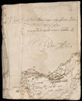
- Creator:
- Aston, Herbert
- Call Number:
- Osborn b4
- Image Count:
- 110
- Resource Type:
- unspecified
- Abstract:
- them "to goe to new England, To build new
- Found in:
- Beinecke Rare Book and Manuscript Library > [Poetical commonplace book], 1634-1640
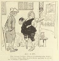
- Creator:
- From the Collection: Hansen, Bert, 1944-
- Published / Created:
- 1910 June 29
- Call Number:
- Ms Coll 67
- Container / Volume:
- Box 11, folder 32
- Image Count:
- 1
- Found in:
- Medical Historical Library, Cushing/Whitney Medical Library > The Bert Hansen collection of medicine and public health in popular graphic art (Ms Coll 67) > Series I: Early Publications > Puck > "July 4, 1775. New England Colonist 'What are you celebrating to-day, Beriah?' Convivial Ditto 'Why, this will be the last opportunity we will ever have to celebrate a "Quiet Fourth"'!"
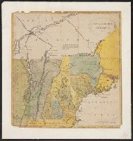
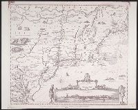
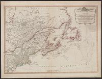
- Creator:
- Faden, William, 1749-1836
- Published / Created:
- 1777
- Call Number:
- 73 1777
- Container / Volume:
- BRBL_00373
- Image Count:
- 1
- Resource Type:
- Maps, Atlases & Globes
- Alternative Title:
- frontiers of New York and New England.
- Found in:
- Beinecke Rare Book and Manuscript Library > A map of the inhabited part of Canada from the French surveys, with the frontiers of New York and New England; from the large survey by Claude Joseph Sauthier. Engraved by Wm. Faden, 1777.
- Creator:
- Cushing, William, 1823-1875
- Published / Created:
- 1843-[1870]
- Call Number:
- WA MSS S-1734
- Image Count:
- 72
- Abstract:
- trip to Hawaii and New England from the
- Found in:
- Beinecke Rare Book and Manuscript Library > William Cushing journal of a voyage to the Columbia River and related papers, 1843-[1870].
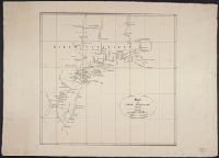
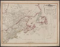
- Creator:
- Jefferys, Thomas, -1771.
- Published / Created:
- November 29th 1755.
- Call Number:
- 76 1755A
- Container / Volume:
- BRBL_00443
- Image Count:
- 2
- Resource Type:
- Maps, Atlases & Globes
- Subject (Geographic):
- New England--Maps--Early works to 1800.
- Found in:
- Beinecke Rare Book and Manuscript Library > A map of the most inhabited part of New England : containing the provinces of Massachusetts Bay and New Hampshire, with the colonies of Konektikut and Rhode Island, divided into counties and townships: The whole composed from actual surveys and its situat
- Published / Created:
- 1788?]
- Call Number:
- 76 1788A
- Container / Volume:
- BRBL_00443
- Image Count:
- 1
- Resource Type:
- Maps, Atlases & Globes
- Subject (Geographic):
- New England--Maps--Early works to 1800
- Found in:
- Beinecke Rare Book and Manuscript Library > New Hampshire Vermont & c.
- Published / Created:
- 1788?]
- Call Number:
- 76 1788
- Container / Volume:
- BRBL_00443
- Image Count:
- 1
- Resource Type:
- Maps, Atlases & Globes
- Subject (Geographic):
- New England--Maps--Early works to 1800
- Found in:
- Beinecke Rare Book and Manuscript Library > New Hampshire Vermont & c.
- Published / Created:
- 1827
- Call Number:
- 755 1650B
- Container / Volume:
- BRBL_00422
- Image Count:
- 1
- Resource Type:
- Maps, Atlases & Globes
- Subject (Geographic):
- New England--Maps
- Found in:
- Beinecke Rare Book and Manuscript Library > Kaart van Nieuw Nederland ... / van R.G. Bennet en J. van Wyk, Rz.
- Published / Created:
- 1833
- Call Number:
- 755 1659
- Container / Volume:
- BRBL_00423
- Image Count:
- 1
- Resource Type:
- Maps, Atlases & Globes
- Subject (Geographic):
- New England--Maps
- Found in:
- Beinecke Rare Book and Manuscript Library > Novi Belgii Novaeque Angliae ... / a Nicolao Joannis Visschero.
- Published / Created:
- [1784?]
- Call Number:
- 762 1784B
- Container / Volume:
- BRBL_00450
- Image Count:
- 1
- Resource Type:
- Maps, Atlases & Globes
- Found in:
- Beinecke Rare Book and Manuscript Library > An accurate map of the State and Province of New Hampshire in New England ... wich exhibits the theatre of this war in that part of the world by Col. Blanchard and the Rev. Mr. Langdon.
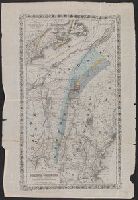
- Creator:
- Hitchcock, Charles H. (Charles Henry), 1836-1919
- Published / Created:
- 1865]
- Call Number:
- 734 1865
- Container / Volume:
- BRBL_00379
- Image Count:
- 1
- Resource Type:
- Maps, Atlases & Globes
- Subject (Topic):
- Railroads--New England--Maps
- Found in:
- Beinecke Rare Book and Manuscript Library > Map illustrating the geological position of the Golconda gold mines / by C.H. Hitchcock ; to which has been added the railway connections by J.H. Colton.
- Published / Created:
- 1794
- Call Number:
- 755cea 1794
- Container / Volume:
- BRBL_00441
- Image Count:
- 4
- Resource Type:
- Maps, Atlases & Globes
- Found in:
- Beinecke Rare Book and Manuscript Library > A New and Correct Chart of the Coast of New England and New York with the adjacent parts of Nova Scotia and New Brunswick from Cape Sable to the entrance of Hudsons or North River by Captain Holland.
- Published / Created:
- 1794 May 12
- Call Number:
- 755 1794G
- Container / Volume:
- BRBL_00436
- Image Count:
- 1
- Resource Type:
- Maps, Atlases & Globes
- Found in:
- Beinecke Rare Book and Manuscript Library > A new and correct map of the British colonies in North America comprehending eastern Canada with the province of Quebec, New Brunswick, Nova Scotia, and the Government of Newfoundland [cartographic material] : with the adjacent states of New England, Verm
- Published / Created:
- 1794 May 12
- Call Number:
- 755 1794E
- Container / Volume:
- BRBL_00436
- Image Count:
- 1
- Resource Type:
- Maps, Atlases & Globes
- Found in:
- Beinecke Rare Book and Manuscript Library > A new and correct map of the British colonies in North America comprehending eastern Canada with the province of Quebec, New Brunswick, Nova Scotia, and the Government of Newfoundland [cartographic material] : with the adjacent states of New England, Verm
- Published / Created:
- 1794 May 12
- Call Number:
- 71 1794A
- Container / Volume:
- BRBL_00687
- Image Count:
- 1
- Resource Type:
- Maps, Atlases & Globes
- Found in:
- Beinecke Rare Book and Manuscript Library > A new and correct map of the British colonies in North America comprehending eastern Canada with the province of Quebec, New Brunswick, Nova Scotia, and the Government of Newfoundland [cartographic material] : with the adjacent states of New England, Verm
- Published / Created:
- 12th May, 1794.
- Call Number:
- 71 1794L
- Container / Volume:
- BRBL_00726
- Image Count:
- 1
- Resource Type:
- Maps, Atlases & Globes
- Found in:
- Beinecke Rare Book and Manuscript Library > A new and correct map of the British colonies in North America comprehending eastern Canada with the province of Quebec, New Brunswick, Nova Scotia, and the Government of Newfoundland [cartographic material] : with the adjacent states of New England, Verm
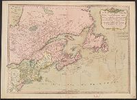
- Creator:
- Thornton, John, fl. 1652-1701
- Published / Created:
- [ca. 1673?]
- Call Number:
- 71 1673
- Container / Volume:
- BRBL_00360
- Image Count:
- 1
- Resource Type:
- Maps, Atlases & Globes
- Found in:
- Beinecke Rare Book and Manuscript Library > A new mapp of the north part of America : from Hudson Straights commanly call'd the Norwest Passage, including Newfoundland, New Scotland, New England, Virginia, Maryland & Carolena / made and sold by John Thornton at the signe of England, Scotland & Irel
- Creator:
- Cotton, John, 1584-1652
- Published / Created:
- 1642
- Call Number:
- Mia6 C829 P87
- Image Count:
- 98
- Found in:
- Beinecke Rare Book and Manuscript Library > The powring ovt of the seven vials, or, An exposition, with application of the 16. chapter of the Revelation : preached in sundry sermons, in Boston church in New England / by that learned and reverend, Iohn Cotton B. of Divinity
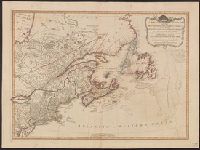
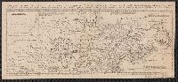
- Creator:
- Bowen, Thomas, d. 1790
- Published / Created:
- 1755]
- Call Number:
- 71 1755E
- Container / Volume:
- BRBL_00687
- Image Count:
- 1
- Resource Type:
- Maps, Atlases & Globes
- Description:
- scotia, Newfoundland, New England, part of
- Found in:
- Beinecke Rare Book and Manuscript Library > A map of the British and French settlements in North America / T. Bowen, sculpt[or].