Search
You Searched For
Search Results
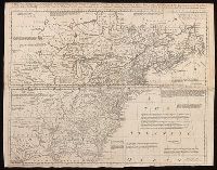
- Creator:
- Robert Sayer and John Bennett (Firm)
- Published / Created:
- 1776
- Call Number:
- 755 1776
- Container / Volume:
- BRBL_00430
- Image Count:
- 1
- Resource Type:
- Maps, Atlases & Globes
- Found in:
- Beinecke Rare Book and Manuscript Library > A general map of the middle British colonies, in America [cartographic material] : Containing Virginia, Maryland, the Delaware counties, Pennsylvania and New Jersey. With the addition of New York, and the greatest part of New England, as also of the borde
- Creator:
- From the Collection: Johnson, James Weldon, 1871-1938
- Published / Created:
- after 1926
- Call Number:
- JWJ MSS 49
- Container / Volume:
- Box 110, folder 978
- Image Count:
- 22
- Description:
- New England by Rowan A. Wakefield
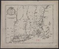
- Found in:
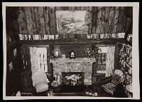
- Beinecke Rare Book and Manuscript Library > James Weldon Johnson and Grace Nail Johnson papers (JWJ MSS 49) > Series IX: Photographs > Candid Portraits and Snapshots > Interior of "Five Acres," Great Barrington, Massachusetts
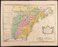
- Published / Created:
- 1849
- Call Number:
- 76 1849
- Container / Volume:
- BRBL_00445
- Image Count:
- 1
- Resource Type:
- Maps, Atlases & Globes
- Subject (Geographic):
- New England--Maps
- Found in:
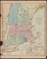
- Beinecke Rare Book and Manuscript Library > Map of New England. New York and Buffalo.
- Published / Created:
- [1804?]
- Call Number:
- 76 1804
- Container / Volume:
- BRBL_00443
- Image Count:
- 1
- Resource Type:
- Maps, Atlases & Globes
- Subject (Geographic):
- New England--Maps
- Found in:
- Beinecke Rare Book and Manuscript Library > Bowles's New one-sheet map of New England; ...
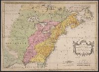
- Creator:
- Bishop, Abraham, 1763-1844.
- Published / Created:
- 1802.
- Call Number:
- Kingsley Misc. Pamphlets 17
- Image Count:
- 168
- Resource Type:
- Books, Journals & Pamphlets
- Subject (Topic):
- Church and state--New England.
- Found in:
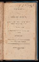
- Beinecke Rare Book and Manuscript Library > Proofs of a conspiracy, against Christianity, and the government of the United States : exhibited in several views of the union of church and state in New-England / by Abraham Bishop.
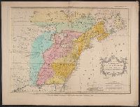
- Published / Created:
- [1736?]
- Call Number:
- 755 1736
- Container / Volume:
- BRBL_00728
- Image Count:
- 1
- Resource Type:
- Maps, Atlases & Globes
- Found in:
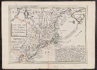
- Beinecke Rare Book and Manuscript Library > New England, New York, New Jersey and Pensylvania.
- Creator:
- Bowen, Thomas, -1790
- Published / Created:
- 1755]
- Call Number:
- BrSides Folio 2019 104
- Image Count:
- 1
- Resource Type:
- Maps, Atlases & Globes
- Description:
- scotia, Newfoundland, New England, part of
- Found in:
- Beinecke Rare Book and Manuscript Library > A map of the British and French settlements in North America / T. Bowen, sculpt.
- Creator:
- From the Collection: O'Neill, Eugene, 1888-1953
- Published / Created:
- [1947]
- Call Number:
- YCAL MSS 123
- Container / Volume:
- Box 146, folder 2591-2593
- Image Count:
- 17
- Found in:
- Beinecke Rare Book and Manuscript Library > Eugene O'Neill papers (YCAL MSS 123) > Oversize > Mourning Becomes Electra > Photographs of seventeen drawings by Albert M. Pyke of scenes in motion picture by Dudley Nichols (in Series V)
- Creator:
- Palairet, Jean, 1697-1774, cartographer.
- Published / Created:
- 1755
- Call Number:
- BrSides Double Folio 2019 111
- Image Count:
- 1
- Resource Type:
- Maps, Atlases & Globes
- Found in:
- Beinecke Rare Book and Manuscript Library > Carte des possessions angloises & françoises du continent de l'Amérique septentrionale / Thos. Kitchin, sculpt.
- Creator:
- Palairet, Jean, 1697-1774, cartographer.
- Call Number:
- 755 1755G
- Image Count:
- 1
- Resource Type:
- Maps, Atlases & Globes
- Found in:
- Beinecke Rare Book and Manuscript Library > Carte des possessions angloises & françoises du continent de l'Amérique septentrionale / Thos. Kitchin, sculpt.
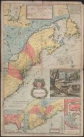
- Published / Created:
- [1775?]
- Call Number:
- 76cea 1775A
- Container / Volume:
- BRBL_00446
- Image Count:
- 1
- Resource Type:
- Maps, Atlases & Globes
- Description:
- Insets: The Town of Boston in New
- Subject (Geographic):
- New England--Maps--Early works to 1800
- Found in:
- Beinecke Rare Book and Manuscript Library > A Map of the Coast of New England from Staten Island to the Island of Breton; as it was actualy survey'd by Capt Cyprian Southback.
- Creator:
- Palairet, Jean, 1697-1774
- Published / Created:
- 1755
- Call Number:
- 755 1755E
- Container / Volume:
- BRBL_00427
- Image Count:
- 1
- Resource Type:
- Maps, Atlases & Globes
- Found in:
- Beinecke Rare Book and Manuscript Library > Carte des possessions angloises & françoises du continent de l'Amérique septentrionale / Thos. Kitchin, sculpt.
- Published / Created:
- [1775?]
- Call Number:
- 76cea 1775
- Container / Volume:
- BRBL_00446
- Image Count:
- 1
- Resource Type:
- Maps, Atlases & Globes
- Description:
- Insets: The Town of Boston in new
- Subject (Geographic):
- New England--Maps--Early works to 1800
- Found in:
- Beinecke Rare Book and Manuscript Library > A Map of the Coast of New England from Staten Island of Breton; as if was actualy survey'd by Capt. Cyprian Southback.
- Creator:
- American Automobile Association
- Published / Created:
- c1917.
- Call Number:
- 76gmb 1917A
- Container / Volume:
- BRBL_00446
- Image Count:
- 2
- Resource Type:
- Maps, Atlases & Globes
- Alternative Title:
- Lower New England main-traveled routes :
- Description:
- On verso: 10 ancillary maps, New
- Subject (Geographic):
- New England--Maps
- Found in:
- Beinecke Rare Book and Manuscript Library > Lower New England / prepared by Touring Information Board American Automobile Association.
- Published / Created:
- [1702?]
- Call Number:
- 76 1702A
- Container / Volume:
- BRBL_00443
- Image Count:
- 1
- Resource Type:
- Maps, Atlases & Globes
- Subject (Geographic):
- New England--Maps--Early works to 1800
- Found in:
- Beinecke Rare Book and Manuscript Library > An exact map of New England and New York.
- Creator:
- Moll, Herman, -1732
- Published / Created:
- 1715
- Call Number:
- 755 1715C
- Container / Volume:
- BRBL_00425
- Image Count:
- 1
- Resource Type:
- Maps, Atlases & Globes
- Found in:
- Beinecke Rare Book and Manuscript Library > A new and exact map of the dominions of the King of Great Britain on ye continent of North America [cartographic material] : containing Newfoundland, New Scotland, New England, New York, New Jersey, Pensilvania, Maryland, Virginia and Carolina according t
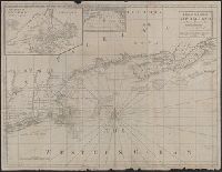
- Published / Created:
- 19--]
- Call Number:
- 76cea 1887
- Container / Volume:
- BRBL_00446
- Image Count:
- 1
- Resource Type:
- Maps, Atlases & Globes
- Alternative Title:
- The Sea of New England
- Found in:
- Beinecke Rare Book and Manuscript Library > Portion of a map of New England in the Public Record Office, London, Eng. : Copied for Chas. Hervey Townshend, Esq. of "Raynham," New Haven, Connecticut, U.S.A. by L.M. Byrne, April, 1887.
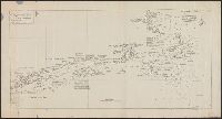
- Creator:
- Rhode, Johann Christoph, cartographer
- Call Number:
- 755 1755AA
- Container / Volume:
- BRBL_00427
- Image Count:
- 1
- Resource Type:
- Maps, Atlases & Globes
- Description:
- , Early printed maps of New England 1513-1800
- Found in:
- Beinecke Rare Book and Manuscript Library > Theatrum belli in America Septentrionali / II. foliis comprehensum jussu Acad. Reg. Scient. et Eleg. Litt. exhibet I. C. Rhode Ac: Geogr. ; Berger, sculpsit berol.