Skip to search
Skip to main content
Skip to first result
Search
You Searched For
maps
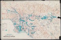
Extent of Digitization
Completely digitized
Search Results
Creator:
Maps
Published / Created:
c1961.
Call Number:
844 L89 1961
Image Count:
1
Description:
Relief shown by shading and spot heights.
Publisher:
Brewster Maps
Subject (Geographic):
California and Los Angeles Metropolitan Area
Subject (Topic):
Industrial sites and Roads
Found in:
Beinecke Rare Book and Manuscript Library > Industrial areas, freeways, and major streets of greater Los Angeles
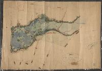
Creator:
Published / Created:
Decr. 1863.
Call Number:
Roll Map 78
Image Count:
2
Resource Type:
cartographic image
Alternative Title:
Map of a portion of Westville and New
Description:
. Manuscript note on verso (partially trimmed): Map
Subject (Geographic):
New Haven (Conn.)
Found in:
Beinecke Rare Book and Manuscript Library > Map of a portion of Westville & New Haven
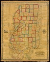
Creator:
Published / Created:
1845.
Call Number:
Roll Map 420
Image Count:
10
Resource Type:
cartographic image
Alternative Title:
State of Mississippi, with a large portion of Louisiana and Alabama
Description:
BEIN Roll Map 420: Mounted on linen
Publisher:
Compiled & published by John La Tourrette and Engraved by S. Stiles, Sherman & Smith
Subject (Geographic):
Mississippi, Alabama, Louisiana, Alabama., Louisiana., and Mississippi.
Subject (Topic):
Administrative and political divisions
Found in:
Beinecke Rare Book and Manuscript Library > An accurate map or delineation of the state of Mississippi, with a large portion of Louisiana & Alabama : showing the communication of land and water between the cities of New Orleans and Mobile : carefully reduced from the original surveys of the United States : being laid off into congressional townships, and divided into mile squares or sections, on the plan adopted by the General Government for surveying Public Lands, so that persons may point to the tract on which they live
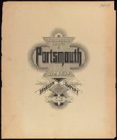
Creator:
Map Company
Published / Created:
1920
Call Number:
783 P83 1920
Container / Volume:
BRBL_00510
Image Count:
30
Resource Type:
Maps , Atlases & Globes
Abstract:
residential sections. Successive Sanborn maps show
Alternative Title:
Portsmouth, Va
Description:
Coordinates not present on map and are
Publisher:
Sanborn Map Company,
Subject (Geographic):
Portsmouth (Va.)--Maps
Subject (Topic):
--Portsmouth--Maps .
Found in:
Beinecke Rare Book and Manuscript Library > Insurance maps of Portsmouth, Virginia.
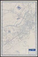
Creator:
Maps
Published / Created:
[1953?]
Call Number:
844gmb R524 1953
Container / Volume:
BRBL_00617
Image Count:
2
Resource Type:
Maps , Atlases & Globes
Alternative Title:
Riverside city map
Description:
Maps of "Recreational area surrounding
Publisher:
Thomas Bros.,
Subject (Geographic):
Riverside (Calif.)--Maps
Subject (Name):
Palomar Observatory--Maps
Subject (Topic):
--Riverside--Maps
Found in:
Beinecke Rare Book and Manuscript Library > Riverside street map / made by Thomas Bros.
Published / Created:
circa 1995-2017
Call Number:
VRC 1990a
Image Count:
8
Found in:
Robert B. Haas Family Arts Library Special Collections > Garvin City Planning Image Collection (VRC 1990a) > U.S. Cities > MASSACHUSETTS > Boston > Maps
Creator:
Published / Created:
1716 ...
Call Number:
1976 1233
Image Count:
42
Description:
BEIN 1976 1233: Imperfect: map "New
Publisher:
Printed for J. Nicholson ...
Subject (Geographic):
Europe
Subject (Topic):
World maps
Found in:
Beinecke Rare Book and Manuscript Library > Forty-two new maps of Asia, Africa, and America ... : all engrav'd, according to the latest observations
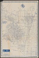
Creator:
Maps
Published / Created:
[1952?]
Call Number:
844gmb P773 1952
Container / Volume:
BRBL_00617
Image Count:
2
Resource Type:
Maps , Atlases & Globes
Alternative Title:
Pomona city map
Description:
, and map of "Downtown Pomona" on verso.
Publisher:
Thomas Bros. Maps ,
Subject (Geographic):
Pomona (Calif.)--Maps
Subject (Name):
Union Oil Company of California
Subject (Topic):
--Pomona--Maps
Found in:
Beinecke Rare Book and Manuscript Library > Pomona and vicinity street map / made by Thomas Bros.
Creator:
Published / Created:
[1715?]
Call Number:
1976 1233
Image Count:
24
Description:
BEIN 1976 1233: Map of the English
Publisher:
Sold by J. Nicholson at the King's-Arms in Little Britain, Benj. Barker and Charles King ..., Benj. Tooke ..., Hen. Clements ..., R. Parker and Ralph Smith under the Royal-Exchange ...
Subject (Geographic):
Europe
Subject (Topic):
World maps
Found in:
Beinecke Rare Book and Manuscript Library > Twenty four new and accurate maps of the several parts of Europe ... : all (except the last) new done, according to the latest observations
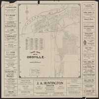
Creator:
Maps
Call Number:
844 Or6 1928
Container / Volume:
BRBL_00607
Image Count:
2
Resource Type:
Maps , Atlases & Globes
Alternative Title:
Map of Oroville, California
Description:
Map of "Butte County, California
Publisher:
Thomas Bros., [1928]
Subject (Geographic):
Butte County (Calif.)--Maps
Subject (Topic):
Streets--California--Oroville--Maps
Found in:
Beinecke Rare Book and Manuscript Library > Thomas Bros. map of Oroville / compiled and published by Thomas Bros. map specialties.