Skip to search
Skip to main content
Skip to first result
Search
You Searched For
Extent of Digitization
Partially digitized
Format
cartographic
Genre
Prints (Visual works)
New Search
Search Results
Call Number:
1978 +73
Collection Title:
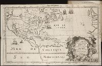
The ecclesiastical history of New-England from its first planting in the year 1620 unto the year of
Image Count:
1
Resource Type:
Books, Journals & Pamphlets
Found in:
Beinecke Rare Book and Manuscript Library > An exact mapp of New England and New York
Call Number:
1989 +19
Collection Title:
A collection of voyages and travels, some now first printed from original manuscripts, others now
Image Count:
1
Resource Type:
Maps, Atlases & Globes
Found in:
Beinecke Rare Book and Manuscript Library > A chart and map of the Gold Coast of Guinea from Rio da Corsa to Ro da Volta. vol. V [5], pl. K
Published / Created:
undated
Call Number:
Folio Q115 H84 1B
Collection Title:
Atlas geographique et physique des regions equinoxiales du nouveau continent, fonde sur des
Image Count:
1
Resource Type:
Maps, Atlases & Globes
Found in:
Beinecke Rare Book and Manuscript Library > Carte du Rio Grande de la Magdalena depuis le 4 [degrees] Latitude jusqu'a son embouchure. No. 24
Creator:
Call Number:
Egg +755E
Collection Title:
Geographical, historical, political, philosophical and mechanical essays : the first, containing an
Image Count:
1
Found in:
Beinecke Rare Book and Manuscript Library > A general map of the middle British colonies in America
Creator:
Call Number:
Pequot H41
Collection Title:
Aenmerckelycke historische reys-beschryvinge door verscheyde landen veel grooter als die van geheel
Image Count:
1
Found in:
Beinecke Rare Book and Manuscript Library > Carte d'un nouueau monde, entre le nouueau Mexique et la mer glacialle
Creator:
Call Number:
Taylor 256
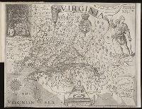
Collection Title:
A map of Virginia : vvith a description of the covntrey, the commodities, people, government and
Image Count:
1
Found in:
Beinecke Rare Book and Manuscript Library > Virginia discouered and described by Captayn John Smith
Call Number:
WeInd Ehc 762J
Collection Title:
A description of the Spanish islands and settlements on the coast of the West Indies / compiled
Image Count:
1
Resource Type:
Maps, Atlases & Globes
Found in:
Beinecke Rare Book and Manuscript Library > The island of Hispaniola called by the French St. Domingo. Subject to France and Spain
Call Number:
1977 +379
Collection Title:
Geografia; cioe, Descrittione vniversale della terra. Partita in due volumi, nel primo de' quali si
Image Count:
1
Found in:
Beinecke Rare Book and Manuscript Library > A new map of that part of Africacalled the coast of Guinea ...
Creator:
Call Number:
1977 Folio 96
Collection Title:
The West-India atlas: or, A compendious description of the West-Indies: illustrated with forty
Image Count:
1
Resource Type:
Maps, Atlases & Globes
Found in:
Beinecke Rare Book and Manuscript Library > Jamaica from the latest surveys; improved and engraved by Thomas Jefferys geographer to the king
Creator:
Call Number:
1977 Folio 96
Collection Title:
The West-India atlas: or, A compendious description of the West-Indies: illustrated with forty
Image Count:
1
Resource Type:
Maps, Atlases & Globes
Found in:
Beinecke Rare Book and Manuscript Library > South part of St. Domingo, of Hispaniola, by Thos Jeffreys geographer to his Majesty
Call Number:
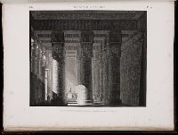
1971 Folio 601
Collection Title:
Description de lEgypte, ou, Recueil de observations et des recherches qui ont ete faites en Egypte
Image Count:
1
Found in:
Beinecke Rare Book and Manuscript Library > Ile d'Elephantine et Syene. pl. 38
Call Number:
1971 Folio 601
Collection Title:
Description de lEgypte, ou, Recueil de observations et des recherches qui ont ete faites en Egypte
Image Count:
1
Found in:
Beinecke Rare Book and Manuscript Library > Ile d'Elephantine. pl. 37
Call Number:
1971 Folio 601
Collection Title:
Description de lEgypte, ou, Recueil de observations et des recherches qui ont ete faites en Egypte
Image Count:
1
Found in:
Beinecke Rare Book and Manuscript Library > Ile d'Elephantine. pl. 36
Call Number:
1971 Folio 601
Collection Title:
Description de lEgypte, ou, Recueil de observations et des recherches qui ont ete faites en Egypte
Image Count:
1
Found in:
Beinecke Rare Book and Manuscript Library > Ile d'Elephantine. pl. 35
Call Number:
1971 Folio 601
Collection Title:
Description de lEgypte, ou, Recueil de observations et des recherches qui ont ete faites en Egypte
Image Count:
1
Found in:
Beinecke Rare Book and Manuscript Library > Ile d'Elephantine. pl. 34
Call Number:
1971 Folio 601
Collection Title:
Description de lEgypte, ou, Recueil de observations et des recherches qui ont ete faites en Egypte
Image Count:
1
Found in:
Beinecke Rare Book and Manuscript Library > Syout. (Lycopolis). pl. 49
Call Number:
1971 Folio 601
Collection Title:
Description de lEgypte, ou, Recueil de observations et des recherches qui ont ete faites en Egypte
Image Count:
1
Found in:
Beinecke Rare Book and Manuscript Library > Syout. (Lycopolis). pl. 48
Call Number:
1971 Folio 601
Collection Title:
Description de lEgypte, ou, Recueil de observations et des recherches qui ont ete faites en Egypte
Image Count:
1
Found in:
Beinecke Rare Book and Manuscript Library > Denderah. (Tentyris). pl. 30
Call Number:
1971 Folio 601
Collection Title:
Description de lEgypte, ou, Recueil de observations et des recherches qui ont ete faites en Egypte
Image Count:
1
Found in:
Beinecke Rare Book and Manuscript Library > Denderah. (Tentyris). pl. 18
Call Number:
1971 Folio 601
Collection Title:
Description de lEgypte, ou, Recueil de observations et des recherches qui ont ete faites en Egypte
Image Count:
1
Found in:
Beinecke Rare Book and Manuscript Library > Alexandrie. pl. 41
Creator:
Call Number:
ZZc70 752L
Collection Title:
Explication de la carte des nouvelles decouvertes au nord de la mer du Sud; par m. de Lisle ...
Image Count:
1
Resource Type:
Maps, Atlases & Globes
Found in:
Beinecke Rare Book and Manuscript Library > Carte de nouvelles decouvertes au nord de la mer du Sud, tant a lest de la Siberie et du Kamtchatka, qua louest de la Nouvelle France
Creator:
Call Number:
1973 Folio 103
Collection Title:
De Nieuwe groote lichtende zee-fakkel ...
Image Count:
1
Resource Type:
Maps, Atlases & Globes
Found in:
Beinecke Rare Book and Manuscript Library > De Oostin-dische zee / Het Eyland Mayota
Creator:
Call Number:
1973 Folio 103
Collection Title:
De Nieuwe groote lichtende zee-fakkel ...
Image Count:
1
Resource Type:
Maps, Atlases & Globes
Found in:
Beinecke Rare Book and Manuscript Library > Des rivier legt op de Hoogte von 18 Graaden Zuyder Breedte aan het Land van de Megosie ter Kuste van Quama / Noord kust van't eyland ...
Creator:
Call Number:
1973 Folio 103
Collection Title:
De Nieuwe groote lichtende zee-fakkel ...
Image Count:
1
Resource Type:
Maps, Atlases & Globes
Found in:
Beinecke Rare Book and Manuscript Library > Madagascar
Call Number:
1977 Folio 78
Collection Title:
A New and accurate chart of the West-India Islands and coast, with the gulf passage through the New
Image Count:
1
Resource Type:
Maps, Atlases & Globes
Found in:
Beinecke Rare Book and Manuscript Library > A plan of Fort St. Louis harbour on the south side of Hispaniola, pl. 31.
Creator:
Call Number:
1977 Folio 78
Collection Title:
A New and accurate chart of the West-India Islands and coast, with the gulf passage through the New
Image Count:
1
Resource Type:
Maps, Atlases & Globes
Found in:
Beinecke Rare Book and Manuscript Library > A new general chart of the West Indies from the latest marine journals and surveys. Regulated and ascertained by astronomical observations
Creator:
Call Number:
C6 033c
Collection Title:
The natural and civil history of the French dominions in North and South America : with an
Image Count:
1
Resource Type:
Maps, Atlases & Globes
Found in:
Beinecke Rare Book and Manuscript Library > An authentic plan of the town and harbour of Cap Francois in the isle of St. Domingo. By Thomas Jefferys geographer to his Royal Highness the Prince of Wales
Creator:
Call Number:
C6 033c
Collection Title:
The natural and civil history of the French dominions in North and South America : with an
Image Count:
1
Resource Type:
Maps, Atlases & Globes
Found in:
Beinecke Rare Book and Manuscript Library > The island of Hispaniola called by the French St. Domingo. Subject to France and Spain. from the best authorities by Thomas Jeffreys, geographer to his Royal Highness the Prince of Wales
Creator:
Call Number:
1977 Folio 96
Collection Title:
The West-India atlas: or, A compendious description of the West-Indies: illustrated with forty
Image Count:
1
Resource Type:
Maps, Atlases & Globes
Found in:
Beinecke Rare Book and Manuscript Library > The harbour of Bluefields.
Creator:
Call Number:
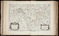
1973 Folio 17
Collection Title:
Atlas francois, contenant les cartes geographiques dans les quelles sont tres exactement remarquez
Image Count:
1
Resource Type:
Maps, Atlases & Globes
Found in:
Beinecke Rare Book and Manuscript Library > La Generalite de Paris divisee ens ses eslections
Creator:
Call Number:
Ee +633gb
Collection Title:
The voyages and travells of the ambassadors sent by Frederick, duke of Holstein, to the great Duke
Image Count:
1
Resource Type:
Maps, Atlases & Globes
Found in:
Beinecke Rare Book and Manuscript Library > The course of the great River Wolga
Call Number:
1977 +392
Collection Title:
A survey of the cities of London and Westminster : containing the original, antiquity, increase
Image Count:
1
Resource Type:
Maps, Atlases & Globes
Found in:
Beinecke Rare Book and Manuscript Library > A mapp of the parishes of St. Clements Danes, St. Mary Savoy; with the Rolls Liberty and Lincolns Inn, taken from the last survey with corrections and additions
Call Number:
1977 +392
Collection Title:
A survey of the cities of London and Westminster : containing the original, antiquity, increase
Image Count:
1
Resource Type:
Maps, Atlases & Globes
Found in:
Beinecke Rare Book and Manuscript Library > Cow Cross being St. Sepulcher's parish without and the Charter House taken from the last survey with corrections
Call Number:
1977 +392
Collection Title:
A survey of the cities of London and Westminster : containing the original, antiquity, increase
Image Count:
1
Resource Type:
Maps, Atlases & Globes
Found in:
Beinecke Rare Book and Manuscript Library > Shoreditch, Norton Folgate, and Crepple Gate without, taken from the last survey with corrections
Call Number:
1977 +392
Collection Title:
A survey of the cities of London and Westminster : containing the original, antiquity, increase
Image Count:
1
Resource Type:
Maps, Atlases & Globes
Found in:
Beinecke Rare Book and Manuscript Library > A map of the parish of St. Dustans Stepney and Stebunheath divided into hamlets
Call Number:
1977 +392
Collection Title:
A survey of the cities of London and Westminster : containing the original, antiquity, increase
Image Count:
1
Resource Type:
Maps, Atlases & Globes
Found in:
Beinecke Rare Book and Manuscript Library > The parish of St. Johns Wapping
Call Number:
1977 +392
Collection Title:
A survey of the cities of London and Westminster : containing the original, antiquity, increase
Image Count:
1
Resource Type:
Maps, Atlases & Globes
Found in:
Beinecke Rare Book and Manuscript Library > A map of the parish if St. Katherines by the Tower
Call Number:
1977 +392
Collection Title:
A survey of the cities of London and Westminster : containing the original, antiquity, increase
Image Count:
1
Resource Type:
Maps, Atlases & Globes
Found in:
Beinecke Rare Book and Manuscript Library > A mapp of the parishes of St. Saviours Southwark and St. Georges taken from the last survey with corrections
Call Number:
1977 +392
Collection Title:
A survey of the cities of London and Westminster : containing the original, antiquity, increase
Image Count:
1
Resource Type:
Maps, Atlases & Globes
Found in:
Beinecke Rare Book and Manuscript Library > St. Olave and St. Mary Magdalen Bermondsey Southwark, taken from the last survey with corrections
Call Number:
1977 +392
Collection Title:
A survey of the cities of London and Westminster : containing the original, antiquity, increase
Image Count:
1
Resource Type:
Maps, Atlases & Globes
Found in:
Beinecke Rare Book and Manuscript Library > Farington Ward without, with its divisions into parishes, taken from the last survey with corrections & amendments
Call Number:
1977 +392
Collection Title:
A survey of the cities of London and Westminster : containing the original, antiquity, increase
Image Count:
1
Resource Type:
Maps, Atlases & Globes
Found in:
Beinecke Rare Book and Manuscript Library > The Wards of Farington within and Baynards Castle with its divisions into parishes taken from the last survey with corrections
Call Number:
1977 +392
Collection Title:
A survey of the cities of London and Westminster : containing the original, antiquity, increase
Image Count:
1
Resource Type:
Maps, Atlases & Globes
Found in:
Beinecke Rare Book and Manuscript Library > Coleman Street Ward and Bashishaw Ward taken from the last survey, with corrections and additions
Call Number:
1977 +392
Collection Title:
A survey of the cities of London and Westminster : containing the original, antiquity, increase
Image Count:
1
Found in:
Beinecke Rare Book and Manuscript Library > The Prospect of Guild Hall
Call Number:
1977 +392
Collection Title:
A survey of the cities of London and Westminster : containing the original, antiquity, increase
Image Count:
1
Resource Type:
Maps, Atlases & Globes
Found in:
Beinecke Rare Book and Manuscript Library > Cheape Ward with its division into parishes, taken from the last survey, with corrections and additions
Call Number:
1977 +392
Collection Title:
A survey of the cities of London and Westminster : containing the original, antiquity, increase
Image Count:
1
Resource Type:
Maps, Atlases & Globes
Found in:
Beinecke Rare Book and Manuscript Library > Bread Street Ward and Cordwainer Ward with it's division into parishes taken from the last survey
Call Number:
1977 +392
Collection Title:
A survey of the cities of London and Westminster : containing the original, antiquity, increase
Image Count:
1
Resource Type:
Maps, Atlases & Globes
Found in:
Beinecke Rare Book and Manuscript Library > Queen Hith Ward and Vintry Ward with their division into parishes taken from the last surveys
Call Number:
1977 +392
Collection Title:
A survey of the cities of London and Westminster : containing the original, antiquity, increase
Image Count:
1
Resource Type:
Maps, Atlases & Globes
Found in:
Beinecke Rare Book and Manuscript Library > Walbrook Ward and Dow Gate Ward with its division into parishes taken from the last surveys
Call Number:
1977 +392
Collection Title:
A survey of the cities of London and Westminster : containing the original, antiquity, increase
Image Count:
1
Resource Type:
Maps, Atlases & Globes
Found in:
Beinecke Rare Book and Manuscript Library > Candlewick Ward with its division into parishes. Corrected from the last survey
Call Number:
1977 +392
Collection Title:
A survey of the cities of London and Westminster : containing the original, antiquity, increase
Image Count:
1
Found in:
Beinecke Rare Book and Manuscript Library > The Royal Exchange of London
Call Number:
1977 +392
Collection Title:
A survey of the cities of London and Westminster : containing the original, antiquity, increase
Image Count:
1
Resource Type:
Maps, Atlases & Globes
Found in:
Beinecke Rare Book and Manuscript Library > Cornhill Ward with its division into parishes, taken from the last survey &c
Call Number:
1977 +392
Collection Title:
A survey of the cities of London and Westminster : containing the original, antiquity, increase
Image Count:
1
Resource Type:
Maps, Atlases & Globes
Found in:
Beinecke Rare Book and Manuscript Library > Bishop Gate Street Ward taken from the last survey and corrected
Call Number:
1977 +392
Collection Title:
A survey of the cities of London and Westminster : containing the original, antiquity, increase
Image Count:
1
Resource Type:
Maps, Atlases & Globes
Found in:
Beinecke Rare Book and Manuscript Library > Part of Aldgate Ward
Call Number:
1977 +392
Collection Title:
A survey of the cities of London and Westminster : containing the original, antiquity, increase
Image Count:
1
Resource Type:
Maps, Atlases & Globes
Found in:
Beinecke Rare Book and Manuscript Library > Aldgate Ward with its division into parishes. Taken from the last survey, with corrections & additions
Call Number:
1977 +392
Collection Title:
A survey of the cities of London and Westminster : containing the original, antiquity, increase
Image Count:
1
Resource Type:
Maps, Atlases & Globes
Found in:
Beinecke Rare Book and Manuscript Library > The Custom House
Call Number:
1977 +392
Collection Title:
A survey of the cities of London and Westminster : containing the original, antiquity, increase
Image Count:
1
Resource Type:
Maps, Atlases & Globes
Found in:
Beinecke Rare Book and Manuscript Library > Portsoken ward being part of the parish of St. Buttolphs Aldgate, taken from the last survey, with corrections and additions
Call Number:
Gfp94 gf525j
Collection Title:
Geographiae vniversae ... opvs ... habentur Cl. Ptolemaei ... Geographicae enarrationis libri octo
Image Count:
1
Resource Type:
Maps, Atlases & Globes
Found in:
Beinecke Rare Book and Manuscript Library > Vniversi orbis descriptop as vsvm navigantivm
Call Number:
1977 1341
Collection Title:
Geographiae vniversae opvs habentur Cl. Ptolemaei ... Geographicae enarationis libri octo [tr. by W
Image Count:
1
Resource Type:
Maps, Atlases & Globes
Found in:
Beinecke Rare Book and Manuscript Library > Vniversi orbis descriptio ad vsvm navigantivm
Call Number:
1977 +435
Collection Title:
Geografia; cioè, Descrittione vniversale della terra. Partita in due volumi, nel primo de' quali si
Image Count:
1
Resource Type:
Maps, Atlases & Globes
Found in:
Beinecke Rare Book and Manuscript Library > [Geographia. Italian]
Call Number:
1977 +435
Collection Title:
Geografia; cioè, Descrittione vniversale della terra. Partita in due volumi, nel primo de' quali si
Image Count:
1
Resource Type:
Maps, Atlases & Globes
Found in:
Beinecke Rare Book and Manuscript Library > [Geographia. Italian]
Call Number:
1975 +1
Collection Title:
L'isole piv famose del mondo descritte da Thomaso Porcacchi da Castiglione Arretino e intagliate da
Image Count:
1
Resource Type:
Maps, Atlases & Globes
Found in:
Beinecke Rare Book and Manuscript Library > Descrittione dell' isola Cuba
Call Number:
1975 +1
Collection Title:
L'isole piv famose del mondo descritte da Thomaso Porcacchi da Castiglione Arretino e intagliate da
Image Count:
1
Resource Type:
Maps, Atlases & Globes
Found in:
Beinecke Rare Book and Manuscript Library > Descrittione dell'isola Spagnuola
Call Number:
1977 +379
Collection Title:
Geografia; cioè, Descrittione vniversale della terra. Partita in due volumi, nel primo de' quali si
Image Count:
1
Resource Type:
Maps, Atlases & Globes
Found in:
Beinecke Rare Book and Manuscript Library > [Geographia. Italian]
Call Number:
Gfp94 +Gi597
Collection Title:
Geografia; cioè, Descrittione vniversale della terra. Partita in due volumi, nel primo de' quali si
Image Count:
1
Resource Type:
Maps, Atlases & Globes
Found in:
Beinecke Rare Book and Manuscript Library > [Geographia. Italian]
Call Number:
1976 +310
Collection Title:
L'isole piv famose del mondo descritte da Thomaso Porcacchi da Castiglione Arretino e intagliate da
Image Count:
1
Resource Type:
Maps, Atlases & Globes
Found in:
Beinecke Rare Book and Manuscript Library > Descrittione dell'isola Cuba
Call Number:
1976 +310
Collection Title:
L'isole piv famose del mondo descritte da Thomaso Porcacchi da Castiglione Arretino e intagliate da
Image Count:
1
Resource Type:
Maps, Atlases & Globes
Found in:
Beinecke Rare Book and Manuscript Library > Descrittione dell'isola Spagnuola
Call Number:
1974 +188
Collection Title:
L'isole piv famose del mondo descritte da Thomaso Porcacchi da Castiglione Arretino e intagliate da
Image Count:
1
Resource Type:
Maps, Atlases & Globes
Found in:
Beinecke Rare Book and Manuscript Library > Descrittione dell' isola Cuba
Call Number:
1974 +188
Collection Title:
L'isole piv famose del mondo descritte da Thomaso Porcacchi da Castiglione Arretino e intagliate da
Image Count:
1
Resource Type:
Maps, Atlases & Globes
Found in:
Beinecke Rare Book and Manuscript Library > Descrittione dell' isola Spagnuola
Call Number:
1985 +31
Collection Title:
L'isole piu famose del mondo / descritte da Thomaso Porcacchi da Castiglione Arretino e intagliate
Image Count:
1
Resource Type:
Maps, Atlases & Globes
Found in:
Beinecke Rare Book and Manuscript Library > Descrittione dell'isola Cuba, che dal Colombo fu scoperta insieme con la Spagnuloa
Call Number:
1985 +31
Collection Title:
L'isole piu famose del mondo / descritte da Thomaso Porcacchi da Castiglione Arretino e intagliate
Image Count:
1
Resource Type:
Maps, Atlases & Globes
Found in:
Beinecke Rare Book and Manuscript Library > Descrittione dell'isola Spagnuola prima iso la scoperta dal Colombo
Call Number:
1977 +246
Collection Title:
Geografia; cioè, Descrittione vniversale della terra. Partita in due volumi, nel primo de' quali si
Image Count:
1
Resource Type:
Maps, Atlases & Globes
Found in:
Beinecke Rare Book and Manuscript Library > Descrittione di tvtto'l mondo, secondo la prattica de Marinari. Vniversi orbis descriptio ad vsvm navigantivm
Call Number:
1977 Folio 78
Collection Title:
A New and accurate chart of the West-India Islands and coast, with the gulf passage through the New
Image Count:
1
Resource Type:
Maps, Atlases & Globes
Found in:
Beinecke Rare Book and Manuscript Library > A plan of Monte-Christe Bay with the Seven Brothers on the north coast of St. Domingo, pl. 38
Call Number:
1977 Folio 78
Collection Title:
A New and accurate chart of the West-India Islands and coast, with the gulf passage through the New
Image Count:
1
Resource Type:
Maps, Atlases & Globes
Found in:
Beinecke Rare Book and Manuscript Library > A plan of the road of Port Paix in the island of Hispaniola, pl. 35.
Creator:
Call Number:
1998 995
Collection Title:
Voyage au pole sud et dans l'Oceanie sur les corvettes l'Astrolabe et la Zelee : execute par ordre
Image Count:
1
Found in:
Beinecke Rare Book and Manuscript Library > Carte geologique de la Patagonie et de la terre de feu
Creator:
Call Number:
1976 Folio 139
Collection Title:
The English pilot: describing the sea-coasts, capes, head-lands, soundings, sands, shoals, rocks
Image Count:
1
Found in:
Beinecke Rare Book and Manuscript Library > A large description of the two chanells in the River Dwina goeing up to the citty of Archangel by John Seller
Call Number:
Gfp94 gf525j
Collection Title:
Geographiae vniversae ... opvs ... habentur Cl. Ptolemaei ... Geographicae enarrationis libri octo
Image Count:
1
Resource Type:
Books, Journals & Pamphlets
Found in:
Beinecke Rare Book and Manuscript Library > America
Call Number:
1977 1341
Collection Title:
Geographiae vniversae opvs habentur Cl. Ptolemaei ... Geographicae enarationis libri octo [tr. by W
Image Count:
1
Resource Type:
Books, Journals & Pamphlets
Found in:
Beinecke Rare Book and Manuscript Library > America
Call Number:
1977 +379
Collection Title:
Geografia; cioe, Descrittione vniversale della terra. Partita in due volumi, nel primo de' quali si
Image Count:
1
Resource Type:
Books, Journals & Pamphlets
Found in:
Beinecke Rare Book and Manuscript Library > [Geographia. Italian]
Call Number:
Gfp94 +Gi597
Collection Title:
Geografia; cioe, Descrittione vniversale della terra. Partita in due volumi, nel primo de' quali si
Image Count:
1
Resource Type:
Books, Journals & Pamphlets
Found in:
Beinecke Rare Book and Manuscript Library > [Geographia. Italian]
Call Number:
1977 +246
Collection Title:
Geografia; cioè, Descrittione vniversale della terra. Partita in due volumi, nel primo de' quali si
Image Count:
1
Resource Type:
Books, Journals & Pamphlets
Found in:
Beinecke Rare Book and Manuscript Library > Descrittione dell-America, o dell'India Occidentale. America
Creator:
Published / Created:
[1578]
Call Number:
1976 Folio 2
Image Count:
1
Found in:
Beinecke Rare Book and Manuscript Library > Specvlvum orbis terrarvm.
Creator:
Published / Created:
1631
Call Number:
Taylor 316
Image Count:
2
Found in:
Beinecke Rare Book and Manuscript Library > Advertisements for the unexperienced planters of New-England, or anywhere, or, The path-way to experience to erect a plantation : With the yearely proceedings of this country in fishing and planting, since the yeare 1614. to the yeare 1630. and their present estate. Also how to prevent the greatest inconveniences, by their proceedings in Virginia, and other plantations, by approved examples. With the countries armes, a description of the coast, harbours, habitations, land-markes, latitude and longitude: with the map, allowed by our royall King Charles. By Captaine Iohn Smith, sometimes governour of Virginia, and admirall of Nevv-England.
Published / Created:
1640
Call Number:
C16 015h
Collection Title:
Lhistoire dv Nouveau monde on Description des Indes Occidentales, contenant dix-huit liures / par
Image Count:
1
Found in:
Beinecke Rare Book and Manuscript Library > Paraguay, O Prov. de Rio de la Plata cum adiacentibus Provinviis quas vocant Tucuman, et Sta. Cruz de la Sierra
Published / Created:
1640
Call Number:
C16 015h
Collection Title:
Lhistoire dv Nouveau monde on Description des Indes Occidentales, contenant dix-huit liures / par
Image Count:
1
Found in:
Beinecke Rare Book and Manuscript Library > Chili
Published / Created:
1640
Call Number:
C16 015h
Collection Title:
Lhistoire dv Nouveau monde on Description des Indes Occidentales, contenant dix-huit liures / par
Image Count:
1
Found in:
Beinecke Rare Book and Manuscript Library > Nova Hispanica, Nova Galicia, Guatimala
Published / Created:
1640
Call Number:
C16 015h
Collection Title:
Lhistoire dv Nouveau monde on Description des Indes Occidentales, contenant dix-huit liures / par
Image Count:
1
Found in:
Beinecke Rare Book and Manuscript Library > Florida, et regiones vicinae
Creator:
Published / Created:
1645
Call Number:
Osborn fb190
Collection Title:
Letters to and from Col. Willm Legge, transcribed from the originals, in the possession of William
Image Count:
2
Resource Type:
Archives or Manuscripts
Found in:
Beinecke Rare Book and Manuscript Library > [Letter to William Legge, 1645 Jun 3, Leicester]
Creator:
Published / Created:
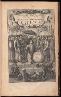
1673
Call Number:
1998 Folio 71
Image Count:
1
Resource Type:
Books, Journals & Pamphlets
Found in:
Beinecke Rare Book and Manuscript Library > An embassy from the East-India Company of the United Provinces, to the Grand Tartar Cham, Emperor of China : deliverd by their excellencies, Peter de Goyer and Jacob de Keyzer, at his imperial city of Peking : wherein the cities, towns, villages, ports, r
Creator:
Published / Created:
1691
Call Number:
1984 Folio 3
Collection Title:
Atlas nouveau : contenant toutes les parties du monde ou sont exactement remarques les empires
Image Count:
1
Resource Type:
Maps, Atlases & Globes
Found in:
Beinecke Rare Book and Manuscript Library > Les Etats de Savoye et de Piemont
Creator:
Published / Created:
1692
Call Number:
1984 Folio 3
Collection Title:
Atlas nouveau : contenant toutes les parties du monde ou sont exactement remarques les empires
Image Count:
1
Resource Type:
Maps, Atlases & Globes
Found in:
Beinecke Rare Book and Manuscript Library > Comte de Namur dresse sur les memoirs les plus nouveaux presente a sa Majeste pour le service de ses troupes par le service de ses troupes par le service de ses troupes ...
Published / Created:
1719
Call Number:
Defoe 50 719db 1
Collection Title:
The life and strange surprizing adventures of Robinson Crusoe, of York, mariner : who lived eight
Image Count:
1
Resource Type:
Maps, Atlases & Globes
Found in:
Beinecke Rare Book and Manuscript Library > A Map of the world, on wch is delineated the voyages of Robinson Cruso
Creator:
Published / Created:
1720
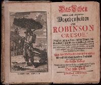
Call Number:
Defoe 52 n720e
Image Count:
14
Resource Type:
Books, Journals & Pamphlets
Found in:
Beinecke Rare Book and Manuscript Library > Das Leben und die gantz ungemeine Begebenheiten des Robinson Crusoe ...
Published / Created:
1720
Call Number:
C6 033c
Collection Title:
The natural and civil history of the French dominions in North and South America : with an
Image Count:
1
Resource Type:
Maps, Atlases & Globes
Found in:
Beinecke Rare Book and Manuscript Library > Plan of New Orleans the capital of Louisiana; with the disposition of its quarters and canals as they have been traced by Mr. de la Tour in the year 1720
Creator:
Published / Created:
1721
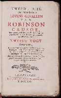
Call Number:
Defoe 52 p721 2
Image Count:
8
Resource Type:
Books, Journals & Pamphlets
Found in:
Beinecke Rare Book and Manuscript Library > Tweede deel der wonderbare levens gevallen van Robinson Crusoe ...
Published / Created:
1722
Call Number:
Zc52 +722pe
Collection Title:
Derrotero de la expedicion en la provincia de los Texas, nuevo reyno de Philipinas, que de orden
Image Count:
2
Resource Type:
Maps, Atlases & Globes
Found in:
Beinecke Rare Book and Manuscript Library > Presidio de n.s. de Loreto en la Bahia
Published / Created:
1739
Call Number:
WeInd Ehc 739
Collection Title:
A description of the Windward Passage, and Gulf of Florida, with the course of the British trading
Image Count:
1
Resource Type:
Maps, Atlases & Globes
Found in:
Beinecke Rare Book and Manuscript Library > A chart of the Bahamas Islands with a description of the Gulf of Florida and Windward passage &c. referr'd from the figures here set down, to the general index annexed ... by J.C
Creator:
Published / Created:
1753
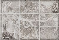
Call Number:
2004 Folio 91
Image Count:
10
Found in:
Beinecke Rare Book and Manuscript Library > Plan stolichnago goroda Sanktpeterburga s izobrazheniem znatnieishikh onago prospektov : izdannyi trudami Imperatorskoi Akademii nauk i khudozhestv.
Published / Created:
1755
Call Number:
ZZc90 755be
Collection Title:
Remarques sur la carte de lAmerique Septentrionale : comprise entre le 28e et le 72e degre de
Image Count:
1
Resource Type:
Maps, Atlases & Globes
Found in:
Beinecke Rare Book and Manuscript Library > Carte de lAmerique septentrionale depuis le 28 degre de latitude jusqau 72
Creator:
Published / Created:
1775 Feb 20
Call Number:
1973 Folio 80
Collection Title:
The West-India atlas: or, A compendious description of the West-Indies: illustrated with forty
Image Count:
1
Resource Type:
Prints & Photographs
Found in:
Beinecke Rare Book and Manuscript Library > Curacao from the Dutch originals of Gerard Van Keulen
Creator:
Published / Created:
1775 Feb 20
Call Number:
1973 Folio 80
Collection Title:
The West-India atlas: or, A compendious description of the West-Indies: illustrated with forty
Image Count:
1
Resource Type:
Prints & Photographs
Found in:
Beinecke Rare Book and Manuscript Library > The Virgin Islands from English and Danish surveys
Branch:v1.60.98 ,Deployed:2024-05-01T09:16:18-04:00