Search
You Searched For
Search Results
- Call Number:
- CF2041 +L54
- Collection Title:
- A true & exact history of the island of Barbados. Illustrated with a mapp of the island, as also
- Image Count:
- 1
- Resource Type:
- Maps, Atlases & Globes
- Found in:
- Beinecke Rare Book and Manuscript Library > A topographicall description and admeasurement of the yland of Barbados in the West Indyaes with the m.rs names of the seuerall plantacons
- Creator:
- Sanson, Nicolas, 1600-1667
- Call Number:
- 1978 Folio 106
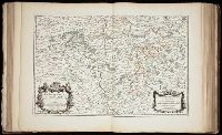
- Collection Title:
- Maps of the Orinoco-Essequibo region, South America. Compiled for the Commission appointed by the
- Image Count:
- 1
- Resource Type:
- Maps, Atlases & Globes
- Found in:
- Beinecke Rare Book and Manuscript Library > Map of Guiana and Caribana by N. Sanson d'Abbeville, Paris, 1656
- Creator:
- Bry, Theodor de, 1528-1598
- Call Number:
- 1978 Folio 106
- Collection Title:
- Maps of the Orinoco-Essequibo region, South America. Compiled for the Commission appointed by the
- Image Count:
- 1
- Resource Type:
- Maps, Atlases & Globes
- Found in:
- Beinecke Rare Book and Manuscript Library > Map of Guiana by Theodore de Bry, 1599
- Creator:
- Raleigh, Walter, Sir, 1552?-1618
- Call Number:
- 1978 Folio 106
- Collection Title:
- Maps of the Orinoco-Essequibo region, South America. Compiled for the Commission appointed by the
- Image Count:
- 1
- Resource Type:
- Maps, Atlases & Globes
- Found in:
- Beinecke Rare Book and Manuscript Library > Chart of Guiana by Sir Walter Raleigh, [1595?]
- Call Number:
- 1973 Folio 114
- Collection Title:
- The English pilot: describing the West-India navigation, from Hudson's-Bay to the river Amazones
- Image Count:
- 1
- Resource Type:
- Maps, Atlases & Globes
- Found in:
- Beinecke Rare Book and Manuscript Library > An exact draught of the Gulf of Darien & the coast to Porto Bello with Panama in the South Sea & the Scotch settlement in Calledonia
- Call Number:
- 1973 Folio 114
- Collection Title:
- The English pilot: describing the West-India navigation, from Hudson's-Bay to the river Amazones
- Image Count:
- 1
- Resource Type:
- Maps, Atlases & Globes
- Found in:
- Beinecke Rare Book and Manuscript Library > A new and correct large chart of the tradeing part of the West Indies
- Call Number:
- 1973 Folio 114
- Collection Title:
- The English pilot: describing the West-India navigation, from Hudson's-Bay to the river Amazones
- Image Count:
- 1
- Resource Type:
- Maps, Atlases & Globes
- Found in:
- Beinecke Rare Book and Manuscript Library > A draught of the coast of Guiana from the river Oronoque to the river Amazones
- Call Number:
- 1973 Folio 114
- Collection Title:
- The English pilot: describing the West-India navigation, from Hudson's-Bay to the river Amazones
- Image Count:
- 1
- Resource Type:
- Maps, Atlases & Globes
- Found in:
- Beinecke Rare Book and Manuscript Library > A description of the ports and islands upon the coast between the Amazons and Cape Florida
- Call Number:
- 1973 Folio 114
- Collection Title:
- The English pilot: describing the West-India navigation, from Hudson's-Bay to the river Amazones
- Image Count:
- 1
- Resource Type:
- Maps, Atlases & Globes
- Found in:
- Beinecke Rare Book and Manuscript Library > A new chart of the Bahama Islands and the Windward passage
- Call Number:
- 1973 Folio 114
- Collection Title:
- The English pilot: describing the West-India navigation, from Hudson's-Bay to the river Amazones
- Image Count:
- 1
- Resource Type:
- Maps, Atlases & Globes
- Found in:
- Beinecke Rare Book and Manuscript Library > The island of Jamaica
- Creator:
- Price, Charles, fl. 1700-1707
- Call Number:
- 1973 Folio 114
- Collection Title:
- The English pilot: describing the West-India navigation, from Hudson's-Bay to the river Amazones
- Image Count:
- 1
- Resource Type:
- Maps, Atlases & Globes
- Found in:
- Beinecke Rare Book and Manuscript Library > A correct chart of Hispaniola with the Windward Passage
- Call Number:
- 1973 Folio 114
- Collection Title:
- The English pilot: describing the West-India navigation, from Hudson's-Bay to the river Amazones
- Image Count:
- 1
- Resource Type:
- Maps, Atlases & Globes
- Found in:
- Beinecke Rare Book and Manuscript Library > A correct chart of the Caribbee Islands
- Call Number:
- 1973 Folio 114
- Collection Title:
- The English pilot: describing the West-India navigation, from Hudson's-Bay to the river Amazones
- Image Count:
- 1
- Resource Type:
- Maps, Atlases & Globes
- Found in:
- Beinecke Rare Book and Manuscript Library > A large draft of South Carolina from Cape Roman to Port Royall
- Call Number:
- 1973 Folio 114
- Collection Title:
- The English pilot: describing the West-India navigation, from Hudson's-Bay to the river Amazones
- Image Count:
- 1
- Resource Type:
- Maps, Atlases & Globes
- Found in:
- Beinecke Rare Book and Manuscript Library > A large draft of the island Antegua
- Call Number:
- 1973 Folio 114
- Collection Title:
- The English pilot: describing the West-India navigation, from Hudson's-Bay to the river Amazones
- Image Count:
- 1
- Resource Type:
- Maps, Atlases & Globes
- Found in:
- Beinecke Rare Book and Manuscript Library > Barbados
- Creator:
- Tiddeman, Mark
- Call Number:
- 1973 Folio 114
- Collection Title:
- The English pilot: describing the West-India navigation, from Hudson's-Bay to the river Amazones
- Image Count:
- 1
- Resource Type:
- Maps, Atlases & Globes
- Found in:
- Beinecke Rare Book and Manuscript Library > A draught of Virginia from the capes to York in York River and to Kuiquotan or Hamton in James River
- Call Number:
- 1973 Folio 114
- Collection Title:
- The English pilot: describing the West-India navigation, from Hudson's-Bay to the river Amazones
- Image Count:
- 1
- Resource Type:
- Maps, Atlases & Globes
- Found in:
- Beinecke Rare Book and Manuscript Library > Virginia, Maryland, Pennsilvania, east & west New Jarsey
- Creator:
- Tiddeman, Mark
- Call Number:
- 1973 Folio 114
- Collection Title:
- The English pilot: describing the West-India navigation, from Hudson's-Bay to the river Amazones
- Image Count:
- 1
- Resource Type:
- Maps, Atlases & Globes
- Found in:
- Beinecke Rare Book and Manuscript Library > A draught of New York from the Hook to New Yorktown
- Call Number:
- 1973 Folio 114
- Collection Title:
- The English pilot: describing the West-India navigation, from Hudson's-Bay to the river Amazones
- Image Count:
- 1
- Resource Type:
- Maps, Atlases & Globes
- Found in:
- Beinecke Rare Book and Manuscript Library > Island of St. Peters
- Call Number:
- 1973 Folio 114
- Collection Title:
- The English pilot: describing the West-India navigation, from Hudson's-Bay to the river Amazones
- Image Count:
- 1
- Resource Type:
- Maps, Atlases & Globes
- Found in:
- Beinecke Rare Book and Manuscript Library > Port Bonavista
- Call Number:
- 1973 Folio 114
- Collection Title:
- The English pilot: describing the West-India navigation, from Hudson's-Bay to the river Amazones
- Image Count:
- 1
- Resource Type:
- Maps, Atlases & Globes
- Found in:
- Beinecke Rare Book and Manuscript Library > Cattalina Harbor
- Call Number:
- 1973 Folio 114
- Collection Title:
- The English pilot: describing the West-India navigation, from Hudson's-Bay to the river Amazones
- Image Count:
- 1
- Resource Type:
- Maps, Atlases & Globes
- Found in:
- Beinecke Rare Book and Manuscript Library > Bay Bulls, part of Newfoundland
- Call Number:
- 1973 Folio 114
- Collection Title:
- The English pilot: describing the West-India navigation, from Hudson's-Bay to the river Amazones
- Image Count:
- 1
- Resource Type:
- Maps, Atlases & Globes
- Found in:
- Beinecke Rare Book and Manuscript Library > Harbor Grace
- Creator:
- Gaudy Iohn
Parker, S
- Call Number:
- 1973 Folio 114
- Collection Title:
- The English pilot: describing the West-India navigation, from Hudson's-Bay to the river Amazones
- Image Count:
- 1
- Resource Type:
- Maps, Atlases & Globes
- Found in:
- Beinecke Rare Book and Manuscript Library > A chart shewing part of the sea coast of New Foundland from ye Bay of Bulls to little Plecentia ...
- Call Number:
- 1973 Folio 114
- Collection Title:
- The English pilot: describing the West-India navigation, from Hudson's-Bay to the river Amazones
- Image Count:
- 1
- Resource Type:
- Maps, Atlases & Globes
- Found in:
- Beinecke Rare Book and Manuscript Library > A new and correct chart of the coast of New Foundland from Cape Raze to Cape Bonavista
- Call Number:
- 1973 Folio 114
- Collection Title:
- The English pilot: describing the West-India navigation, from Hudson's-Bay to the river Amazones
- Image Count:
- 1
- Resource Type:
- Maps, Atlases & Globes
- Found in:
- Beinecke Rare Book and Manuscript Library > A general chart of the western ocean
- Call Number:
- 1973 Folio 114
- Collection Title:
- The English pilot: describing the West-India navigation, from Hudson's-Bay to the river Amazones
- Image Count:
- 1
- Resource Type:
- Maps, Atlases & Globes
- Found in:
- Beinecke Rare Book and Manuscript Library > A chart of the sea coast of Newfoundland, New Scotland, New England, New York, New Jersey, with Virginia and Maryland
- Call Number:
- 1973 Folio 114
- Collection Title:
- The English pilot: describing the West-India navigation, from Hudson's-Bay to the river Amazones
- Image Count:
- 2
- Resource Type:
- Maps, Atlases & Globes
- Found in:
- Beinecke Rare Book and Manuscript Library > A new generall chart for the West Indies
- Call Number:
- 1973 Folio 114
- Collection Title:
- The English pilot: describing the West-India navigation, from Hudson's-Bay to the river Amazones
- Image Count:
- 1
- Resource Type:
- Maps, Atlases & Globes
- Found in:
- Beinecke Rare Book and Manuscript Library > A new and correct chart of the north part of America from New Found Land to Hudsons Bay
- Call Number:
- 1973 Folio 114
- Collection Title:
- The English pilot: describing the West-India navigation, from Hudson's-Bay to the river Amazones
- Image Count:
- 1
- Resource Type:
- Maps, Atlases & Globes
- Found in:
- Beinecke Rare Book and Manuscript Library > A new and correct chart of the western and southern oceans ...
- Creator:
- Inselin, C
- Call Number:
- 1977 Folio 114
- Collection Title:
- L’atlas curieux ou Le monde represente dans des cartes generales et particulieres du ciel et de la
- Image Count:
- 1
- Resource Type:
- Maps, Atlases & Globes
- Found in:
- Beinecke Rare Book and Manuscript Library > Bourg, chateau, et iardins de Fontaine-bleau
- Creator:
- Russell, J.C
- Call Number:
- Defoe 57 W99 g816
- Collection Title:
- The Swiss family Ro
- Image Count:
- 1
- Resource Type:
- Maps, Atlases & Globes
- Found in:
- Beinecke Rare Book and Manuscript Library > Settlements of the Swiss pastor & his family in the desert island
- Call Number:
- 1976 Folio 94
- Collection Title:
- A new universal atlas containing maps of the various empires, kingdoms, states and republics of the
- Image Count:
- 1
- Resource Type:
- Maps, Atlases & Globes
- Found in:
- Beinecke Rare Book and Manuscript Library > A new map of Maine
- Published / Created:
- Undated
- Call Number:
- 1973 Folio 56
- Collection Title:
- The American pilot, containing the navigation of the sea coast of North America, from the Streights
- Image Count:
- 1
- Resource Type:
- Maps, Atlases & Globes
- Found in:
- Beinecke Rare Book and Manuscript Library > A chart of South Carolina and Georgia
- Creator:
- Bry, Theodor de, 1528-1598
- Call Number:
- 1976 Folio 110
- Collection Title:
- The mariners mirrovr wherin may playnly be seen the courses, heights, distances, depths, sounding
- Image Count:
- 1
- Resource Type:
- Maps, Atlases & Globes
- Found in:
- Beinecke Rare Book and Manuscript Library > The sea coastes of England betweene the Ile of Wight & Douer, with the principal hauens thereof according to their situation and appearing
- Creator:
- Bry, Theodor de, 1528-1598
- Call Number:
- 1976 Folio 110
- Collection Title:
- The mariners mirrovr wherin may playnly be seen the courses, heights, distances, depths, sounding
- Image Count:
- 1
- Resource Type:
- Maps, Atlases & Globes
- Found in:
- Beinecke Rare Book and Manuscript Library > The sea coastes of England, from the Sorlinges by the landes end to Plymouth with the hauens and harbrowghes
- Creator:
- Bry, Theodor de, 1528-1598
- Call Number:
- 1976 Folio 110
- Collection Title:
- The mariners mirrovr wherin may playnly be seen the courses, heights, distances, depths, sounding
- Image Count:
- 1
- Resource Type:
- Maps, Atlases & Globes
- Found in:
- Beinecke Rare Book and Manuscript Library > The sea coastes of Portugal betwene Camino & Montego eue as the countrie there aboutes is lying and situated with all the havens thereof exactly done, and corected with great dilligence
- Creator:
- Visscher, Nicolaes, 1649-1702
- Published / Created:
- Undated
- Call Number:
- 1973 Folio 71
- Collection Title:
- [Atlas nouveau contenant toutes les parties du monde ou sont exactement marques les empires
- Image Count:
- 1
- Resource Type:
- Maps, Atlases & Globes
- Found in:
- Beinecke Rare Book and Manuscript Library > A new mapp of the kingdome of England, representing the princedome of Wales, and other provinces, cities, market towns, with the roads from town to town and the number of reputed miles between them, are given by inspection without scale or compass
- Published / Created:
- Undated
- Call Number:
- 1978 595
- Collection Title:
- El atlas abreviado, o Compendiosa geografia, del mvndo antigvo, y nvevo, segun esta oy dividido
- Image Count:
- 1
- Resource Type:
- Maps, Atlases & Globes
- Found in:
- Beinecke Rare Book and Manuscript Library > Yslas Britanicas enque se comprehenden los reynos de Ynglaterra, Escocia, e Yrlanda
- Published / Created:
- Undated
- Call Number:
- 1975 2757
- Collection Title:
- El atlas abreviado, o, El nuevo compendio de la geografia universal, politica, historica, i curiosa
- Image Count:
- 1
- Resource Type:
- Maps, Atlases & Globes
- Found in:
- Beinecke Rare Book and Manuscript Library > Isles Britanniques ou sont les royaumes d'Angleterre d'Escosse et d'Irlande
- Published / Created:
- Undated
- Call Number:
- 1973 845
- Collection Title:
- Navtica mediterranea / di Bartolomeo Crescentio Romano ... Nella quale si mostra la fabrica delle
- Image Count:
- 1
- Resource Type:
- Maps, Atlases & Globes
- Found in:
- Beinecke Rare Book and Manuscript Library > Civita Vecchia
- Call Number:
- 1989 +19
- Collection Title:
- A collection of voyages and travels, some now first printed from original manuscripts, others now
- Image Count:
- 1
- Resource Type:
- Maps, Atlases & Globes
- Found in:
- Beinecke Rare Book and Manuscript Library > A chart and map of the Gold Coast of Guinea from Rio da Corsa to Ro da Volta. vol. V [5], pl. K
- Published / Created:
- undated
- Call Number:
- Folio Q115 H84 1B
- Collection Title:
- Atlas geographique et physique des regions equinoxiales du nouveau continent, fonde sur des
- Image Count:
- 1
- Resource Type:
- Maps, Atlases & Globes
- Found in:
- Beinecke Rare Book and Manuscript Library > Carte du Rio Grande de la Magdalena depuis le 4 [degrees] Latitude jusqu'a son embouchure. No. 24
- Call Number:
- WeInd Ehc 762J
- Collection Title:
- A description of the Spanish islands and settlements on the coast of the West Indies / compiled
- Image Count:
- 1
- Resource Type:
- Maps, Atlases & Globes
- Found in:
- Beinecke Rare Book and Manuscript Library > The island of Hispaniola called by the French St. Domingo. Subject to France and Spain
- Creator:
- Dakota Territory Centennial Commission
- Call Number:
- Zc35 +961rp
- Collection Title:
- To Celebrate 100 years of Dakota Territory : the Dakota Territorial Centennial Commission presents
- Image Count:
- 1
- Resource Type:
- Maps, Atlases & Globes
- Found in:
- Beinecke Rare Book and Manuscript Library > The lands within the bold boundary were included, at some time or other, but never all at the same time, in Dakota Territory
- Call Number:
- E463 L39
- Collection Title:
- Plavanie vokrug svieta na shliupie Ladogie v 1822, 1823 i 1824 godakh
- Image Count:
- 1
- Resource Type:
- Maps, Atlases & Globes
- Found in:
- Beinecke Rare Book and Manuscript Library > Kapta ...
- Creator:
- Jefferys, Thomas, d. 1771
- Call Number:
- 1977 Folio 96
- Collection Title:
- The West-India atlas: or, A compendious description of the West-Indies: illustrated with forty
- Image Count:
- 1
- Resource Type:
- Maps, Atlases & Globes
- Found in:
- Beinecke Rare Book and Manuscript Library > Jamaica from the latest surveys; improved and engraved by Thomas Jefferys geographer to the king
- Creator:
- Jefferys, Thomas, d. 1771
- Call Number:
- 1977 Folio 96
- Collection Title:
- The West-India atlas: or, A compendious description of the West-Indies: illustrated with forty
- Image Count:
- 1
- Resource Type:
- Maps, Atlases & Globes
- Found in:
- Beinecke Rare Book and Manuscript Library > South part of St. Domingo, of Hispaniola, by Thos Jeffreys geographer to his Majesty
- Creator:
- Bry, Theodor de, 1528-1598
- Call Number:
- 1976 Folio 110
- Collection Title:
- The mariners mirrovr wherin may playnly be seen the courses, heights, distances, depths, sounding
- Image Count:
- 1
- Resource Type:
- Maps, Atlases & Globes
- Found in:
- Beinecke Rare Book and Manuscript Library > The sea coastes of the landes of Poyctou and Bordeaux ...as they shew and appeare, when you sayle there alongst betweene Picquelier and the River of Bordeaux called the Garonne
- Call Number:
- Zc52 843Leb
- Collection Title:
- The legion of liberty
- Image Count:
- 1
- Resource Type:
- Maps, Atlases & Globes
- Found in:
- Beinecke Rare Book and Manuscript Library > Moral map of U.S., Jan. 1837
- Call Number:
- Zc52 833hob
- Collection Title:
- Texas
- Image Count:
- 1
- Resource Type:
- Maps, Atlases & Globes
- Found in:
- Beinecke Rare Book and Manuscript Library > Map of the state of Coahuila and Texas
- Creator:
- Buache, Philippe, 1700-1773
Fuentes, Bartolome de, 17th cent
- Call Number:
- ZZc70 752L
- Collection Title:
- Explication de la carte des nouvelles decouvertes au nord de la mer du Sud; par m. de Lisle ...
- Image Count:
- 1
- Resource Type:
- Maps, Atlases & Globes
- Found in:
- Beinecke Rare Book and Manuscript Library > Carte de nouvelles decouvertes au nord de la mer du Sud, tant a lest de la Siberie et du Kamtchatka, qua louest de la Nouvelle France
- Creator:
- Keulen, Gerard van
Keulen, Johannes van.
Marre, Jan de, 1696-1763.
Vooght, Claes Janszoon, d. 1696.
- Call Number:
- 1973 Folio 103
- Collection Title:
- De Nieuwe groote lichtende zee-fakkel ...
- Image Count:
- 1
- Resource Type:
- Maps, Atlases & Globes
- Found in:
- Beinecke Rare Book and Manuscript Library > De Oostin-dische zee / Het Eyland Mayota
- Creator:
- Keulen, Gerard van
Keulen, Johannes van.
Marre, Jan de, 1696-1763.
Vooght, Claes Janszoon, d. 1696.
- Call Number:
- 1973 Folio 103
- Collection Title:
- De Nieuwe groote lichtende zee-fakkel ...
- Image Count:
- 1
- Resource Type:
- Maps, Atlases & Globes
- Found in:
- Beinecke Rare Book and Manuscript Library > Des rivier legt op de Hoogte von 18 Graaden Zuyder Breedte aan het Land van de Megosie ter Kuste van Quama / Noord kust van't eyland ...
- Creator:
- Keulen, Gerard van
Keulen, Johannes van.
Marre, Jan de, 1696-1763.
Vooght, Claes Janszoon, d. 1696.
- Call Number:
- 1973 Folio 103
- Collection Title:
- De Nieuwe groote lichtende zee-fakkel ...
- Image Count:
- 1
- Resource Type:
- Maps, Atlases & Globes
- Found in:
- Beinecke Rare Book and Manuscript Library > Madagascar
- Call Number:
- 1971 Folio 602
- Collection Title:
- Carte topographique de lEgypte et de plusiers parties des pays limitrophes; levee pendant
- Image Count:
- 1
- Resource Type:
- Maps, Atlases & Globes
- Found in:
- Beinecke Rare Book and Manuscript Library > Le Caire, Belbeis. pl. 24.
- Call Number:
- 1971 Folio 602
- Collection Title:
- Carte topographique de lEgypte et de plusiers parties des pays limitrophes; levee pendant
- Image Count:
- 1
- Resource Type:
- Maps, Atlases & Globes
- Found in:
- Beinecke Rare Book and Manuscript Library > [Map of Egypt, the Red Sea, Palestine, the Sinai Peninsula and other Middle Eastern landmarks]. pl. 2.
- Call Number:
- 1971 Folio 602
- Collection Title:
- Carte topographique de lEgypte et de plusiers parties des pays limitrophes; levee pendant
- Image Count:
- 1
- Resource Type:
- Maps, Atlases & Globes
- Found in:
- Beinecke Rare Book and Manuscript Library > Tableau d'assembalge pour la carte topographique de l'Egypte en 47 feuilles et pour la carte geographique en 3 feuilles.
- Call Number:
- 1977 Folio 78
- Collection Title:
- A New and accurate chart of the West-India Islands and coast, with the gulf passage through the New
- Image Count:
- 1
- Resource Type:
- Maps, Atlases & Globes
- Found in:
- Beinecke Rare Book and Manuscript Library > A plan of Fort St. Louis harbour on the south side of Hispaniola, pl. 31.
- Creator:
- Bennett, John
Sayer, Robert, 1725-1794
- Call Number:
- 1977 Folio 78
- Collection Title:
- A New and accurate chart of the West-India Islands and coast, with the gulf passage through the New
- Image Count:
- 1
- Resource Type:
- Maps, Atlases & Globes
- Found in:
- Beinecke Rare Book and Manuscript Library > A new general chart of the West Indies from the latest marine journals and surveys. Regulated and ascertained by astronomical observations
- Creator:
- Jefferys, Thomas, d. 1771
- Call Number:
- C6 033c
- Collection Title:
- The natural and civil history of the French dominions in North and South America : with an
- Image Count:
- 1
- Resource Type:
- Maps, Atlases & Globes
- Found in:
- Beinecke Rare Book and Manuscript Library > An authentic plan of the town and harbour of Cap Francois in the isle of St. Domingo. By Thomas Jefferys geographer to his Royal Highness the Prince of Wales
- Creator:
- Jefferys, Thomas, d. 1771
- Call Number:
- C6 033c
- Collection Title:
- The natural and civil history of the French dominions in North and South America : with an
- Image Count:
- 1
- Resource Type:
- Maps, Atlases & Globes
- Found in:
- Beinecke Rare Book and Manuscript Library > The island of Hispaniola called by the French St. Domingo. Subject to France and Spain. from the best authorities by Thomas Jeffreys, geographer to his Royal Highness the Prince of Wales
- Call Number:
- 1972 Folio 31
- Collection Title:
- El teniente general D. Jose Manuel de Goyeneche, primer conde de Guaqui; apuntes y datos para la
- Image Count:
- 1
- Resource Type:
- Maps, Atlases & Globes
- Found in:
- Beinecke Rare Book and Manuscript Library > Region del lago Titicaca. Mapa mandado levantar por el General Goyeneche. (Del Archivo del Condo de Guaqui.)
- Creator:
- Jefferys, Thomas, d. 1771
- Call Number:
- 1977 Folio 96
- Collection Title:
- The West-India atlas: or, A compendious description of the West-Indies: illustrated with forty
- Image Count:
- 1
- Resource Type:
- Maps, Atlases & Globes
- Found in:
- Beinecke Rare Book and Manuscript Library > The harbour of Bluefields.
- Creator:
- Sanson, Nicolas, 1600-1667
- Call Number:
- 1973 Folio 17
- Collection Title:
- Atlas francois, contenant les cartes geographiques dans les quelles sont tres exactement remarquez
- Image Count:
- 1
- Resource Type:
- Maps, Atlases & Globes
- Found in:
- Beinecke Rare Book and Manuscript Library > La Generalite de Paris divisee ens ses eslections
- Creator:
- Chantry, John
- Call Number:
- Ee +633gb
- Collection Title:
- The voyages and travells of the ambassadors sent by Frederick, duke of Holstein, to the great Duke
- Image Count:
- 1
- Resource Type:
- Maps, Atlases & Globes
- Found in:
- Beinecke Rare Book and Manuscript Library > The course of the great River Wolga
- Creator:
- Bromley, Walter
- Call Number:
- 1979 Folio 55
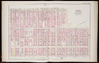
- Collection Title:
- Atlas of the city of New York, Manhattan Island. From actual surveys and official plans, by George
- Image Count:
- 1
- Resource Type:
- Maps, Atlases & Globes
- Found in:
- Beinecke Rare Book and Manuscript Library > Part of ward 19 New York City part of section 5, plate 22
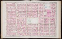
- Creator:
- Bromley, Walter
- Call Number:
- 1979 Folio 55
- Collection Title:
- Atlas of the city of New York, Manhattan Island. From actual surveys and official plans, by George
- Image Count:
- 1
- Resource Type:
- Maps, Atlases & Globes
- Found in:
- Beinecke Rare Book and Manuscript Library > Part of sections 34 & 5, part of wards 19, 20, 21, & 22, plate 20
- Call Number:
- 1977 +392
- Collection Title:
- A survey of the cities of London and Westminster : containing the original, antiquity, increase
- Image Count:
- 1
- Resource Type:
- Maps, Atlases & Globes
- Found in:
- Beinecke Rare Book and Manuscript Library > A mapp of the parishes of St. Clements Danes, St. Mary Savoy; with the Rolls Liberty and Lincolns Inn, taken from the last survey with corrections and additions
- Call Number:
- 1977 +392
- Collection Title:
- A survey of the cities of London and Westminster : containing the original, antiquity, increase
- Image Count:
- 1
- Resource Type:
- Maps, Atlases & Globes
- Found in:
- Beinecke Rare Book and Manuscript Library > Cow Cross being St. Sepulcher's parish without and the Charter House taken from the last survey with corrections
- Call Number:
- 1977 +392
- Collection Title:
- A survey of the cities of London and Westminster : containing the original, antiquity, increase
- Image Count:
- 1
- Resource Type:
- Maps, Atlases & Globes
- Found in:
- Beinecke Rare Book and Manuscript Library > Shoreditch, Norton Folgate, and Crepple Gate without, taken from the last survey with corrections
- Call Number:
- 1977 +392
- Collection Title:
- A survey of the cities of London and Westminster : containing the original, antiquity, increase
- Image Count:
- 1
- Resource Type:
- Maps, Atlases & Globes
- Found in:
- Beinecke Rare Book and Manuscript Library > A map of the parish of St. Dustans Stepney and Stebunheath divided into hamlets
- Call Number:
- 1977 +392
- Collection Title:
- A survey of the cities of London and Westminster : containing the original, antiquity, increase
- Image Count:
- 1
- Resource Type:
- Maps, Atlases & Globes
- Found in:
- Beinecke Rare Book and Manuscript Library > The parish of St. Johns Wapping
- Call Number:
- 1977 +392
- Collection Title:
- A survey of the cities of London and Westminster : containing the original, antiquity, increase
- Image Count:
- 1
- Resource Type:
- Maps, Atlases & Globes
- Found in:
- Beinecke Rare Book and Manuscript Library > A map of the parish if St. Katherines by the Tower
- Call Number:
- 1977 +392
- Collection Title:
- A survey of the cities of London and Westminster : containing the original, antiquity, increase
- Image Count:
- 1
- Resource Type:
- Maps, Atlases & Globes
- Found in:
- Beinecke Rare Book and Manuscript Library > A mapp of the parishes of St. Saviours Southwark and St. Georges taken from the last survey with corrections
- Call Number:
- 1977 +392
- Collection Title:
- A survey of the cities of London and Westminster : containing the original, antiquity, increase
- Image Count:
- 1
- Resource Type:
- Maps, Atlases & Globes
- Found in:
- Beinecke Rare Book and Manuscript Library > St. Olave and St. Mary Magdalen Bermondsey Southwark, taken from the last survey with corrections
- Call Number:
- 1977 +392
- Collection Title:
- A survey of the cities of London and Westminster : containing the original, antiquity, increase
- Image Count:
- 1
- Resource Type:
- Maps, Atlases & Globes
- Found in:
- Beinecke Rare Book and Manuscript Library > Farington Ward without, with its divisions into parishes, taken from the last survey with corrections & amendments
- Call Number:
- 1977 +392
- Collection Title:
- A survey of the cities of London and Westminster : containing the original, antiquity, increase
- Image Count:
- 1
- Resource Type:
- Maps, Atlases & Globes
- Found in:
- Beinecke Rare Book and Manuscript Library > The Wards of Farington within and Baynards Castle with its divisions into parishes taken from the last survey with corrections
- Call Number:
- 1977 +392
- Collection Title:
- A survey of the cities of London and Westminster : containing the original, antiquity, increase
- Image Count:
- 1
- Resource Type:
- Maps, Atlases & Globes
- Found in:
- Beinecke Rare Book and Manuscript Library > Coleman Street Ward and Bashishaw Ward taken from the last survey, with corrections and additions
- Call Number:
- 1977 +392
- Collection Title:
- A survey of the cities of London and Westminster : containing the original, antiquity, increase
- Image Count:
- 1
- Resource Type:
- Maps, Atlases & Globes
- Found in:
- Beinecke Rare Book and Manuscript Library > Cheape Ward with its division into parishes, taken from the last survey, with corrections and additions
- Call Number:
- 1977 +392
- Collection Title:
- A survey of the cities of London and Westminster : containing the original, antiquity, increase
- Image Count:
- 1
- Resource Type:
- Maps, Atlases & Globes
- Found in:
- Beinecke Rare Book and Manuscript Library > Bread Street Ward and Cordwainer Ward with it's division into parishes taken from the last survey
- Call Number:
- 1977 +392
- Collection Title:
- A survey of the cities of London and Westminster : containing the original, antiquity, increase
- Image Count:
- 1
- Resource Type:
- Maps, Atlases & Globes
- Found in:
- Beinecke Rare Book and Manuscript Library > Queen Hith Ward and Vintry Ward with their division into parishes taken from the last surveys
- Call Number:
- 1977 +392
- Collection Title:
- A survey of the cities of London and Westminster : containing the original, antiquity, increase
- Image Count:
- 1
- Resource Type:
- Maps, Atlases & Globes
- Found in:
- Beinecke Rare Book and Manuscript Library > Walbrook Ward and Dow Gate Ward with its division into parishes taken from the last surveys
- Call Number:
- 1977 +392
- Collection Title:
- A survey of the cities of London and Westminster : containing the original, antiquity, increase
- Image Count:
- 1
- Resource Type:
- Maps, Atlases & Globes
- Found in:
- Beinecke Rare Book and Manuscript Library > Candlewick Ward with its division into parishes. Corrected from the last survey
- Call Number:
- 1977 +392
- Collection Title:
- A survey of the cities of London and Westminster : containing the original, antiquity, increase
- Image Count:
- 1
- Resource Type:
- Maps, Atlases & Globes
- Found in:
- Beinecke Rare Book and Manuscript Library > Cornhill Ward with its division into parishes, taken from the last survey &c
- Call Number:
- 1977 +392
- Collection Title:
- A survey of the cities of London and Westminster : containing the original, antiquity, increase
- Image Count:
- 1
- Resource Type:
- Maps, Atlases & Globes
- Found in:
- Beinecke Rare Book and Manuscript Library > Bishop Gate Street Ward taken from the last survey and corrected
- Call Number:
- 1977 +392
- Collection Title:
- A survey of the cities of London and Westminster : containing the original, antiquity, increase
- Image Count:
- 1
- Resource Type:
- Maps, Atlases & Globes
- Found in:
- Beinecke Rare Book and Manuscript Library > Part of Aldgate Ward
- Call Number:
- 1977 +392
- Collection Title:
- A survey of the cities of London and Westminster : containing the original, antiquity, increase
- Image Count:
- 1
- Resource Type:
- Maps, Atlases & Globes
- Found in:
- Beinecke Rare Book and Manuscript Library > Aldgate Ward with its division into parishes. Taken from the last survey, with corrections & additions
- Call Number:
- 1977 +392
- Collection Title:
- A survey of the cities of London and Westminster : containing the original, antiquity, increase
- Image Count:
- 1
- Resource Type:
- Maps, Atlases & Globes
- Found in:
- Beinecke Rare Book and Manuscript Library > The Custom House
- Call Number:
- 1977 +392
- Collection Title:
- A survey of the cities of London and Westminster : containing the original, antiquity, increase
- Image Count:
- 1
- Resource Type:
- Maps, Atlases & Globes
- Found in:
- Beinecke Rare Book and Manuscript Library > Portsoken ward being part of the parish of St. Buttolphs Aldgate, taken from the last survey, with corrections and additions
- Call Number:
- Gfp94 gf525j
- Collection Title:
- Geographiae vniversae ... opvs ... habentur Cl. Ptolemaei ... Geographicae enarrationis libri octo
- Image Count:
- 1
- Resource Type:
- Maps, Atlases & Globes
- Found in:
- Beinecke Rare Book and Manuscript Library > Vniversi orbis descriptop as vsvm navigantivm
- Call Number:
- 1977 1341
- Collection Title:
- Geographiae vniversae opvs habentur Cl. Ptolemaei ... Geographicae enarationis libri octo [tr. by W
- Image Count:
- 1
- Resource Type:
- Maps, Atlases & Globes
- Found in:
- Beinecke Rare Book and Manuscript Library > Vniversi orbis descriptio ad vsvm navigantivm
- Call Number:
- 1977 +435
- Collection Title:
- Geografia; cioè, Descrittione vniversale della terra. Partita in due volumi, nel primo de' quali si
- Image Count:
- 1
- Resource Type:
- Maps, Atlases & Globes
- Found in:
- Beinecke Rare Book and Manuscript Library > [Geographia. Italian]
- Call Number:
- 1977 +435
- Collection Title:
- Geografia; cioè, Descrittione vniversale della terra. Partita in due volumi, nel primo de' quali si
- Image Count:
- 1
- Resource Type:
- Maps, Atlases & Globes
- Found in:
- Beinecke Rare Book and Manuscript Library > [Geographia. Italian]
- Call Number:
- 1975 +1
- Collection Title:
- L'isole piv famose del mondo descritte da Thomaso Porcacchi da Castiglione Arretino e intagliate da
- Image Count:
- 1
- Resource Type:
- Maps, Atlases & Globes
- Found in:
- Beinecke Rare Book and Manuscript Library > Descrittione dell' isola Cuba
- Call Number:
- 1975 +1
- Collection Title:
- L'isole piv famose del mondo descritte da Thomaso Porcacchi da Castiglione Arretino e intagliate da
- Image Count:
- 1
- Resource Type:
- Maps, Atlases & Globes
- Found in:
- Beinecke Rare Book and Manuscript Library > Descrittione dell'isola Spagnuola
- Call Number:
- 1977 +379
- Collection Title:
- Geografia; cioè, Descrittione vniversale della terra. Partita in due volumi, nel primo de' quali si
- Image Count:
- 1
- Resource Type:
- Maps, Atlases & Globes
- Found in:
- Beinecke Rare Book and Manuscript Library > [Geographia. Italian]
- Call Number:
- Gfp94 +Gi597
- Collection Title:
- Geografia; cioè, Descrittione vniversale della terra. Partita in due volumi, nel primo de' quali si
- Image Count:
- 1
- Resource Type:
- Maps, Atlases & Globes
- Found in:
- Beinecke Rare Book and Manuscript Library > [Geographia. Italian]
- Call Number:
- 1976 +310
- Collection Title:
- L'isole piv famose del mondo descritte da Thomaso Porcacchi da Castiglione Arretino e intagliate da
- Image Count:
- 1
- Resource Type:
- Maps, Atlases & Globes
- Found in:
- Beinecke Rare Book and Manuscript Library > Descrittione dell'isola Cuba
- Call Number:
- 1976 +310
- Collection Title:
- L'isole piv famose del mondo descritte da Thomaso Porcacchi da Castiglione Arretino e intagliate da
- Image Count:
- 1
- Resource Type:
- Maps, Atlases & Globes
- Found in:
- Beinecke Rare Book and Manuscript Library > Descrittione dell'isola Spagnuola