Skip to search
Skip to main content
Skip to first result
Search
You Searched For
Extent of Digitization
Partially digitized
Genre
Engravings
Genre
Maps
Genre
Maps in books
New Search
Search Results
Creator:
Call Number:
Taylor 256
Collection Title:
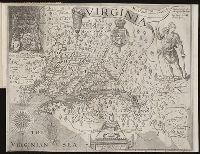
A map of Virginia : vvith a description of the covntrey, the commodities, people, government and
Image Count:
1
Abstract:
Inset depicting Powhatan.
Subject (Geographic):
Virginia --History --Colonial period, ca. 1600-1775
Subject (Topic):
Voyages and travels
Collection Created:
At Oxford : Printed by Joseph Barnes, 1612
Found in:
Beinecke Rare Book and Manuscript Library > Virginia discouered and described by Captayn John Smith
Call Number:
1973 Folio 114
Collection Title:
The English pilot: describing the West-India navigation, from Hudson's-Bay to the river Amazones
Image Count:
1
Resource Type:
Maps, Atlases & Globes
Subject (Geographic):
Atlantic Ocean --Maps --Early works to 1800, Maryland --Maps --Early works to 1800, New Jersey --Maps --Early works to 1800, and Virginia --Maps --Early works to 1800
Subject (Topic):
Navigation --Early works to 1800, Pilot guides --Atlantic Coast (U.S.) --Early works to 1800, and Pilot guides --Caribbean Area --Early works to 1800
Collection Created:
London : Printed for W. and J. Mount, T. Page and son, on Tower-Hill, MDCCLIX [1759]
Found in:
Beinecke Rare Book and Manuscript Library > Virginia, Maryland, Pennsilvania, east & west New Jarsey
Call Number:
1977 +392
Collection Title:
A survey of the cities of London and Westminster : containing the original, antiquity, increase
Image Count:
1
Resource Type:
Maps, Atlases & Globes
Description:
Plate between p. 150-151.
Subject (Geographic):
London (England)--History
Collection Created:
London : Printed for A. Churchill, J. Knapton, R. Knaplock, J. Walthoe [and 6 others], 1720
Found in:
Beinecke Rare Book and Manuscript Library > Walbrook Ward and Dow Gate Ward with its division into parishes taken from the last surveys
Published / Created:
Undated
Call Number:
1978 595
Collection Title:
El atlas abreviado, o Compendiosa geografia, del mvndo antigvo, y nvevo, segun esta oy dividido
Image Count:
1
Resource Type:
Maps, Atlases & Globes
Description:
Imperfect: wormed with very slight loss of text. and Verso blank
Subject (Geographic):
British Isles --Maps --Early works to 1800
Subject (Name):
Laso, Francisco
Subject (Topic):
Atlases --Early works to 1800
Collection Created:
En Amberes: A costa de Francisco Laso, mercader de libros, enfrente de S. Phelipe el Real de Madrid, ano 1711
Found in:
Beinecke Rare Book and Manuscript Library > Yslas Britanicas enque se comprehenden los reynos de Ynglaterra, Escocia, e Yrlanda
Creator:
Published / Created:
ca. 1730-ca. 1800]
Call Number:
1973 Folio 71
Image Count:
1
Resource Type:
Maps, Atlases & Globes
Description:
All volumes bound to match 1973 Folio 72. Factitious collection of about 549 maps taken from the atlases of the 17th and the beginning of the 18th cent., put together with the title "Atlas" and bound in 6 volumes. These volumes originally bore the imprint: Amstelaedamii apvd Reiniervm & Josvam Ottens. Over these words on the title-pages of v. 1-2, 4-6 is the name of Henrik de Leth who painted them. Volume 3 has only the erased imprint of Ottens., For fuller description see Phillips 3448 and C. Koeman's Atlantes Neerlandici, bibliography of terrestrial, maritime and celestial atlases and pilot books, published in the Netherlands up to 1800, Amsterdam c1967-71, v. 2, p. 63-83., and Maps by P. Schenck and son, G. Valck, F. de Wit, N. Visscher and others.
Publisher:
chez J. Covens & C. Mortier,
Subject (Geographic):
Denmark --Maps --Early works to 1800
Subject (Name):
Reiner et Josua Ottens (Firm), Schenk, Peter, 1660-1718 or 1719., and Valck, G. (Gerard), 1651 or 1652-1726.
Subject (Topic):
Atlases--Early works to 1800.
Found in:
Beinecke Rare Book and Manuscript Library > [Atlas nouveau contenant toutes les parties du monde ou sont exactement marqués les empires, monarchies, royaumes, états, republiques &c. Le tout recueilli par les meilleurs geógraphes.]
Published / Created:
[Ca. 1612]
Call Number:
Pequot G325
Collection Title:
Descriptio ac delineatio geographica detectionis freti, sive, transitus ad occasum supra terras
Image Count:
1
Description:
Bound in after p. [40]. and Scale [ca. 1:10,000,000].
Subject (Geographic):
Barents Sea --Maps --Early works to 1800 and Norwegian Sea --Maps --Early works to 1800
Collection Created:
Amsterodami Ex officina Hesse lij Gerardi. Anno 1613
Found in:
Beinecke Rare Book and Manuscript Library > [Barents Sea and Norwegian Sea]
Creator:
Published / Created:
Undated
Call Number:
Taylor 216A
Collection Title:
Iohn Huighen van Linschoten, his Discours of Voyages into ye Easte & West Indies : deuided into
Image Count:
1
Description:
Bound in following title page of second book. and Map has small tear at bottom fold in center.
Subject (Geographic):
Africa --Maps --Early works to 1800, Cape of Good Hope --Maps, Congo (Democratic Republic) --Maps, and Madagascar --Maps --Early works to 1800
Subject (Name):
Wolfe, John, d. 1601, printer
Subject (Topic):
Voyages and travels --Early works to 1800
Collection Created:
[London] : Printed at London by [John Windet for] Iohn Wolfe, printer to ye Honorable Cittie of London, [1598]
Found in:
Beinecke Rare Book and Manuscript Library > [Map of southern Africa and Madagascar]
Call Number:
1983 Folio 44
Collection Title:
Isolario : descrittione geografico-historica, sacro-profana, antico-moderna, politica, naturale, e
Image Count:
3
Resource Type:
Books, Journals & Pamphlets
Subject (Geographic):
Lazzaretto Nuovo Island (Italy) and Murano (Italy)--Maps, Pictorial--Early works to 1800
Subject (Topic):
Geography --Early works to 1800 and Islands--Italy
Collection Created:
In Venetia : A’ spese dell’autore, 1696 [i.e. 1697]
Found in:
Beinecke Rare Book and Manuscript Library > [Selected pages]
Published / Created:
[Ca. 1612]
Call Number:
Pequot G325
Collection Title:
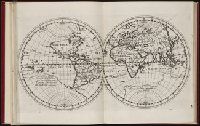
Descriptio ac delineatio geographica detectionis freti, sive, transitus ad occasum supra terras
Image Count:
1
Description:
Bound in after p. [8]., Printed on recto: "B" in lower right margin., and Scale [ca. 1:160,000,000].
Subject (Topic):
World maps --Early works to 1800
Collection Created:
Amsterodami Ex officina Hesse lij Gerardi. Anno 1613
Found in:
Beinecke Rare Book and Manuscript Library > [World map]
Branch:v1.61.6 ,Deployed:2024-06-12T09:55:36-04:00