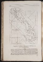
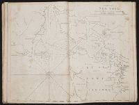
The English pilot: describing the West-India navigation, from Hudson's-Bay to the river Amazones
Image Count:
1
Subject (Geographic):
Atlantic Ocean --Maps --Early works to 1800, Boston (Mass.) --Maps --Early works to 1800, Boston Harbor (Mass.) --Maps --Early works to 1800, New England --Maps --Early works to 1800, New York (State) --Maps --Early works to 1800, and Rhode Island --Maps --Early works to 1800
Subject (Topic):
Navigation --Early works to 1800, Pilot guides --Atlantic Coast (U.S.) --Early works to 1800, and Pilot guides --Caribbean Area --Early works to 1800
BEIN 2003 Folio 85: No. 7 of 45 maps bound together with binder's spine title: Atlas of America; ms. table of contents. Bookplate of Paul Mellon., Engraved by: Thomas Jefferys, geographer to his majesty., Hand-colored., Kershaw, Kenneth. Early printed maps of Canada, vol. 4, no. 1015., Map shows details of British and French positions during the siege of Quebec and table of references identifies British military units., Overlay provides details of changed position of British troops at the battle of September 13, 1759., Published in: A general topography of North America, London, 1768., and Scale 1:18,500.
Publisher:
Thos. Jefferys, the corner of St. Martins Lane Charing Cross
Subject (Geographic):
QueÌbec (QueÌbec) -- Maps -- Early works to 1800, QueÌbec Campaign, 1759 -- Maps, and United States -- History -- French and Indian War, 1755-1763 -- Maps
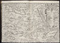
John Huighen van Linschoten, his Discours of Voyages into ye Easte & West Indies
Image Count:
1
Description:
[Scale ca. 1:14,000,000]., Bound in following p. 214., Map folded irregularly., and Map has small tear at bottom fold in center outside frame of map.
Subject (Geographic):
Africa, East --Maps, Egypt --Maps --Early works to 1800, Ethiopia --Maps --Early works to 1800, Mediterranean Sea --Maps --Early works to 1800, Nile River --Maps --Early works to 1800, and Tigris River Valley
Subject (Topic):
Voyages and travels --Early works to 1800
Collection Created:
[London] : Printed at London by [John Windet for] Iohn Wolfe, printer to ye Honorable Cittie of London, [1598]
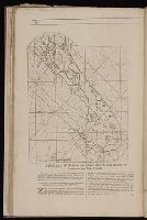
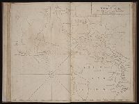
The English pilot: describing the West-India navigation, from Hudson's-Bay to the river Amazones
Image Count:
1
Subject (Geographic):
Long Island (N.Y.) --Maps --Early works to 1800, New York (N.Y.) --Maps --To 1800, New York (State) --Maps --Early works to 1800, and Staten Island (New York, N.Y.) --Maps
Subject (Topic):
Navigation --Early works to 1800, Pilot guides --Atlantic Coast (U.S.) --Early works to 1800, and Pilot guides --Caribbean Area --Early works to 1800
Collection Created:
London : Printed for W. and J. Mount, T. Page and son, on Tower-Hill, MDCCLX [1760]
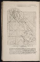
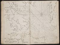
Bowen, Emanuel, d. 1767 Cook, James, fl. 1766, creator
Published / Created:
Decr. 1766
Call Number:
2003 Folio 85
Image Count:
1
Description:
BEIN 2003 Folio 85: No. 24 of 45 maps bound together with binder's spine title: Atlas of America; ms. table of contents. Bookplate: Robinson. Bookplate of Paul Mellon., by their humble servt. James Cook ; approv'd of by Mr. Joiner 20 years a pilot of that place., Depths shown by soundings., Emanl. Bowen sculpt., Hand colored., and Scale [1:65,000].
Publisher:
By the author
Subject (Geographic):
Port Royal (S.C.) -- Maps -- Early works to 1800
Subject (Topic):
Nautical charts -- Port Royal (S.C.) -- Early works to 1800