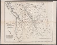
Includes text., Mounted on linen., and Relief shown by hachures.
Publisher:
U.S. Senate,
Subject (Geographic):
Northwest, Pacific--Maps
Subject (Name):
Abert, John James, 1788-1863, Arnold, Robert M.--Ownership, Hudson's Bay Company, Hudson's Bay Company--Maps, Stansbury, M. H, Stenzel, Franz--Ownership, and Stenzel, Kathryn M.--(Kathryn Mathi
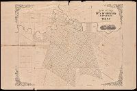
Shows railroads, corporate land ownership, plats of Marquette and Negaunee, sawmill locations in all or parts of sections T.47-48 N, R. 25-27 W.
Description:
Backed with linen. Manuscript annotations on map. Manuscript title on verso: Marquette Iron Region. From the Richard H. Rickard Papers., Coordinates not present on map and are approximated., Detached from: A statement of the plan of the St. Mary's Canal Mineral Land Company (New York : Baker & Godwin, printers, 1859)., and Relief shown by hachures.
Publisher:
[Baker & Godwin, printers],
Subject (Geographic):
Michigan--Upper Peninsula
Subject (Name):
Collins Iron Company--Maps., Excelsior Iron Company--Maps., Jackson Iron Company (Fayette, Mich.)--Maps., Peninsula Iron Company--Maps., Pioneer Iron Company--Maps., and Rickard, Richard H.,---1885--Owner
Subject (Topic):
Iron mines and mining, Iron mines and mining--Michigan--Upper Peninsula--Maps., Real property, and Real property--Michigan--Upper Peninsula--Maps.
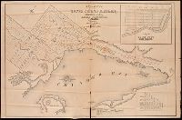
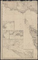
Coordinates not present on map and are approximated., Imperfect: mutilated, with some loss of text. Manuscript annotations on map. Manuscript title on verso: Thunder Bay Silver Mining District. From the Richard H. Rickard Papers., Inset: plan of town plot, Fort William., and Relief shown by hachures.
Publisher:
[publisher not identified],
Subject (Name):
Copp Clark Company and Rickard, Richard H.,---1885--Ownership.
Subject (Topic):
Real property--Ontario--Thunder Bay Region--Maps. and Silver mines and mining--Ontario--Thunder Bay Region--Maps.
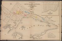
Coordinates not present on map and are approximated., Imperfect. Mutilated with loss of text., Inset: plan of town plot, Fort William., and Relief shown by hachures.
Publisher:
[publisher not identified],
Subject (Name):
Copp Clark Company and Rickard, Richard H.,---1885--Ownership.
Subject (Topic):
Real property--Ontario--Thunder Bay Region--Maps. and Silver mines and mining--Ontario--Thunder Bay Region--Maps.
Includes names of property owners., Manuscript notes in unidentified hand. Stamp on verso: T.W. Streeter. Label fragment on verso., and Railroad vignette below title.
Publisher:
[publisher not identified],
Subject (Geographic):
Houston (Tex.)--Maps
Subject (Name):
Gray, E. F. and Streeter, Thomas W.--(Thomas Winthrop),--1883-1965--Stamp.
Imray, James F. (James Frederick), 1829?-1891, author James Imray and Son, publisher
Call Number:
23cea 1884
Container / Volume:
BRBL_00021
Image Count:
2
Resource Type:
Maps, Atlases & Globes
Alternative Title:
Cape Northumberland to Cape Howe and Chart no. 2, Cape Northumberland to Cape Howe
Description:
Imperfect: sheet torn in half, edges chipped, with some loss of text. Backed with paper. Manuscript annotations on map. Some locations highlighted in yellow. Label on verso: Chart and In lower left margin: Cor. VII, 83, XII, 83, 84, VII, VIII, IX.
Mitchell, John Murray, 1858-1905 Norris Peters Co United States. Hydrographic Office
Published / Created:
[1896?]
Call Number:
231 1896
Container / Volume:
BRBL_00020
Image Count:
1
Resource Type:
Maps, Atlases & Globes
Alternative Title:
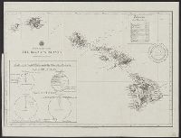
North Pacific Ocean, the Hawaiian Islands
Description:
"The Norris P, At head of title: North Pacific Ocean., Includes chart showing trade of the United States with the Hawaiian Islands in 1896, and table of distances from Honolulu to various cities on the Pacific Rim., and Manuscript annotations on verso.