Search
You Searched For
Search Results
- Published / Created:
- 1846
- Call Number:
- 1976 Folio 93
- Collection Title:
- A new universal atlas containing maps of the various empires, kingdoms, states and republics of the
- Image Count:
- 1
- Resource Type:
- Maps, Atlases & Globes
- Found in:
- Beinecke Rare Book and Manuscript Library > 9. Connecticut
- Creator:
- Pine, John, 1690-1756
Rocque, John, d. 1762
Tinney, John
- Published / Created:
- 1746
- Call Number:
- 2002 Folio 94
- Image Count:
- 1
- Resource Type:
- Maps, Atlases & Globes
- Found in:
- Beinecke Rare Book and Manuscript Library > A contracted scetch of the plan of London &c. : printed on 24 sheets of imperial paper, to shew the general appearance of the whole : for the use of those who bind it in a book, and for the better comprehension of the divisions mentioned in the index.
- Creator:
- Dodsley, Robert, 1703-1764
Evans, Lewis, 1700?-1756.
Turner, James, d. 1759, engraver.
- Published / Created:
- 1755
- Call Number:
- 391 +1755h
- Collection Title:
- Geographical, historical, political, philosophical and mechanical essays : the first, containing an
- Image Count:
- 1
- Resource Type:
- Maps, Atlases & Globes
- Found in:
- Beinecke Rare Book and Manuscript Library > A general map of the middle British colonies in America
- Creator:
- Bowles, Carington, 1724-1793
Evans, Lewis, 1700?-1756.
- Published / Created:
- 1771
- Call Number:
- Franklin 391 1755e
- Collection Title:
- Geographical, historical, political, philosophical and mechanical essays : the first, containing an
- Image Count:
- 1
- Found in:
- Beinecke Rare Book and Manuscript Library > A general map of the middle British colonies in America
- Creator:
- Evans, Lewis, 1700?-1756
- Call Number:
- Egg +755E
- Collection Title:
- Geographical, historical, political, philosophical and mechanical essays : the first, containing an
- Image Count:
- 1
- Found in:
- Beinecke Rare Book and Manuscript Library > A general map of the middle British colonies in America
- Creator:
- Seller, John, fl. 1658-1698
- Call Number:
- 1976 Folio 139
- Collection Title:
- The English pilot: describing the sea-coasts, capes, head-lands, soundings, sands, shoals, rocks
- Image Count:
- 1
- Found in:
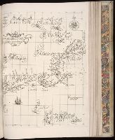
- Beinecke Rare Book and Manuscript Library > A large description of the two chanells in the River Dwina goeing up to the citty of Archangel by John Seller
- Creator:
- Clark, William, 1770-1838
Lewis, Samuel, 1753 or 4-1822
- Published / Created:
- [ca. 1814]
- Call Number:
- Zc10 814Le
- Collection Title:
- History of the expedition under the command of Captains Lewis and Clark, to the sources of the
- Image Count:
- 2
- Resource Type:
- Maps, Atlases & Globes
- Found in:
- Beinecke Rare Book and Manuscript Library > A map of Lewis and Clark's track, across the western portion of North America fom the Mississippi to the Pacific Ocean; by order of the Executive of the United States . In 1804, 5 & 6
- Call Number:
- 1977 +392
- Collection Title:
- A survey of the cities of London and Westminster : containing the original, antiquity, increase
- Image Count:
- 1
- Resource Type:
- Maps, Atlases & Globes
- Found in:
- Beinecke Rare Book and Manuscript Library > A map of the parish if St. Katherines by the Tower
- Call Number:
- 1977 +392
- Collection Title:
- A survey of the cities of London and Westminster : containing the original, antiquity, increase
- Image Count:
- 1
- Resource Type:
- Maps, Atlases & Globes
- Found in:
- Beinecke Rare Book and Manuscript Library > A map of the parish of St. Dustans Stepney and Stebunheath divided into hamlets
- Call Number:
- 1977 +392
- Collection Title:
- A survey of the cities of London and Westminster : containing the original, antiquity, increase
- Image Count:
- 1
- Resource Type:
- Maps, Atlases & Globes
- Found in:
- Beinecke Rare Book and Manuscript Library > A mapp of the parishes of St. Clements Danes, St. Mary Savoy; with the Rolls Liberty and Lincolns Inn, taken from the last survey with corrections and additions
- Call Number:
- 1977 +392
- Collection Title:
- A survey of the cities of London and Westminster : containing the original, antiquity, increase
- Image Count:
- 1
- Resource Type:
- Maps, Atlases & Globes
- Found in:
- Beinecke Rare Book and Manuscript Library > A mapp of the parishes of St. Saviours Southwark and St. Georges taken from the last survey with corrections
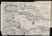
- Creator:
- Bennett, John
Sayer, Robert, 1725-1794
- Call Number:
- 1977 Folio 78
- Collection Title:
- A New and accurate chart of the West-India Islands and coast, with the gulf passage through the New
- Image Count:
- 1
- Resource Type:
- Maps, Atlases & Globes
- Found in:
- Beinecke Rare Book and Manuscript Library > A new general chart of the West Indies from the latest marine journals and surveys. Regulated and ascertained by astronomical observations
- Call Number:
- 1977 +379
- Collection Title:
- Geografia; cioe, Descrittione vniversale della terra. Partita in due volumi, nel primo de' quali si
- Image Count:
- 1
- Found in:
- Beinecke Rare Book and Manuscript Library > A new map of that part of Africacalled the coast of Guinea ...
- Call Number:
- 1977 Folio 78
- Collection Title:
- A New and accurate chart of the West-India Islands and coast, with the gulf passage through the New
- Image Count:
- 1
- Resource Type:
- Maps, Atlases & Globes
- Found in:
- Beinecke Rare Book and Manuscript Library > A plan of Fort St. Louis harbour on the south side of Hispaniola, pl. 31.
- Call Number:
- 1977 Folio 78
- Collection Title:
- A New and accurate chart of the West-India Islands and coast, with the gulf passage through the New
- Image Count:
- 1
- Resource Type:
- Maps, Atlases & Globes
- Found in:
- Beinecke Rare Book and Manuscript Library > A plan of Monte-Christe Bay with the Seven Brothers on the north coast of St. Domingo, pl. 38
- Call Number:
- 1977 Folio 78
- Collection Title:
- A New and accurate chart of the West-India Islands and coast, with the gulf passage through the New
- Image Count:
- 1
- Resource Type:
- Maps, Atlases & Globes
- Found in:
- Beinecke Rare Book and Manuscript Library > A plan of the road of Port Paix in the island of Hispaniola, pl. 35.
- Call Number:
- 1977 +392
- Collection Title:
- A survey of the cities of London and Westminster : containing the original, antiquity, increase
- Image Count:
- 1
- Resource Type:
- Maps, Atlases & Globes
- Found in:
- Beinecke Rare Book and Manuscript Library > Aldgate Ward with its division into parishes. Taken from the last survey, with corrections & additions
- Call Number:
- 1971 Folio 601
- Collection Title:
- Description de lEgypte, ou, Recueil de observations et des recherches qui ont ete faites en Egypte
- Image Count:
- 1
- Found in:
- Beinecke Rare Book and Manuscript Library > Alexandrie. pl. 41
- Call Number:
- Gfp94 gf525j
- Collection Title:
- Geographiae vniversae ... opvs ... habentur Cl. Ptolemaei ... Geographicae enarrationis libri octo
- Image Count:
- 1
- Resource Type:
- Books, Journals & Pamphlets
- Found in:
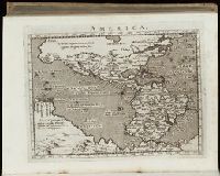
- Beinecke Rare Book and Manuscript Library > America
- Call Number:
- 1977 1341
- Collection Title:
- Geographiae vniversae opvs habentur Cl. Ptolemaei ... Geographicae enarationis libri octo [tr. by W
- Image Count:
- 1
- Resource Type:
- Books, Journals & Pamphlets
- Found in:
- Beinecke Rare Book and Manuscript Library > America
- Creator:
- Jefferys, Thomas, d. 1771
- Call Number:
- C6 033c
- Collection Title:
- The natural and civil history of the French dominions in North and South America : with an
- Image Count:
- 1
- Resource Type:
- Maps, Atlases & Globes
- Found in:
- Beinecke Rare Book and Manuscript Library > An authentic plan of the town and harbour of Cap Francois in the isle of St. Domingo. By Thomas Jefferys geographer to his Royal Highness the Prince of Wales
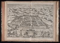
- Creator:
- Nieuhof, Johannes, 1618-1672
- Published / Created:
- 1673
- Call Number:
- 1998 Folio 71
- Image Count:
- 1
- Resource Type:
- Books, Journals & Pamphlets
- Found in:
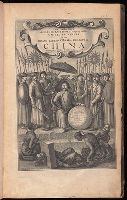
- Beinecke Rare Book and Manuscript Library > An embassy from the East-India Company of the United Provinces, to the Grand Tartar Cham, Emperor of China : deliverd by their excellencies, Peter de Goyer and Jacob de Keyzer, at his imperial city of Peking : wherein the cities, towns, villages, ports, r
- Call Number:
- 1978 +73
- Collection Title:
- The ecclesiastical history of New-England from its first planting in the year 1620 unto the year of
- Image Count:
- 1
- Resource Type:
- Books, Journals & Pamphlets
- Found in:
- Beinecke Rare Book and Manuscript Library > An exact mapp of New England and New York
- Call Number:
- 1977 +392
- Collection Title:
- A survey of the cities of London and Westminster : containing the original, antiquity, increase
- Image Count:
- 1
- Resource Type:
- Maps, Atlases & Globes
- Found in:
- Beinecke Rare Book and Manuscript Library > Bishop Gate Street Ward taken from the last survey and corrected
- Published / Created:
- [1565?]
- Call Number:
- 1977 +251
- Collection Title:
- Terzo volume delle nauigationi et viaggi / raccolto gia da m. Gio. Battista Ramusio
- Container / Volume:
- v. 3
- Image Count:
- 1
- Found in:
- Beinecke Rare Book and Manuscript Library > Brasil
- Published / Created:
- [1565?]
- Call Number:
- Taylor 115 3
- Collection Title:
- Terzo volume delle nauigationi et viaggi / raccolto gia da m. Gio. Battista Ramusio
- Container / Volume:
- v. 3
- Image Count:
- 1
- Found in:
- Beinecke Rare Book and Manuscript Library > Brasil
- Published / Created:
- [1565?]
- Call Number:
- 2001 +204 3
- Collection Title:
- Terzo volume delle nauigationi et viaggi / raccolto gia da m. Gio. Battista Ramusio
- Image Count:
- 1
- Found in:
- Beinecke Rare Book and Manuscript Library > Brasil
- Call Number:
- 1977 +392
- Collection Title:
- A survey of the cities of London and Westminster : containing the original, antiquity, increase
- Image Count:
- 1
- Resource Type:
- Maps, Atlases & Globes
- Found in:
- Beinecke Rare Book and Manuscript Library > Bread Street Ward and Cordwainer Ward with it's division into parishes taken from the last survey
- Call Number:
- 1977 +392
- Collection Title:
- A survey of the cities of London and Westminster : containing the original, antiquity, increase
- Image Count:
- 1
- Resource Type:
- Maps, Atlases & Globes
- Found in:
- Beinecke Rare Book and Manuscript Library > Candlewick Ward with its division into parishes. Corrected from the last survey
- Published / Created:
- 1661
- Call Number:
- 1976 Folio 152
- Collection Title:
- Arcano del mare di D. Rvberto Dvdleo dvca di Nortvmbria, e conte di VVarvich. Diviso in libri sei ...
- Container / Volume:
- Volume 2
- Image Count:
- 1
- Found in:
- Beinecke Rare Book and Manuscript Library > Carta particolare della nuova Belgia e parte della nuova Anglia
- Creator:
- Bouttats, Gaspard, b. ca. 1640, engraver
- Call Number:
- Pequot H41
- Collection Title:
- Aenmerckelycke historische reys-beschryvinge door verscheyde landen veel grooter als die van geheel
- Image Count:
- 1
- Found in:
- Beinecke Rare Book and Manuscript Library > Carte d'un nouueau monde, entre le nouueau Mexique et la mer glacialle
- Published / Created:
- 1755
- Call Number:
- ZZc90 755be
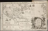
- Collection Title:
- Remarques sur la carte de lAmerique Septentrionale : comprise entre le 28e et le 72e degre de
- Image Count:
- 1
- Resource Type:
- Maps, Atlases & Globes
- Found in:
- Beinecke Rare Book and Manuscript Library > Carte de lAmerique septentrionale depuis le 28 degre de latitude jusqau 72
- Creator:
- Buache, Philippe, 1700-1773
Fuentes, Bartolome de, 17th cent
- Call Number:
- ZZc70 752L
- Collection Title:
- Explication de la carte des nouvelles decouvertes au nord de la mer du Sud; par m. de Lisle ...
- Image Count:
- 1
- Resource Type:
- Maps, Atlases & Globes
- Found in:
- Beinecke Rare Book and Manuscript Library > Carte de nouvelles decouvertes au nord de la mer du Sud, tant a lest de la Siberie et du Kamtchatka, qua louest de la Nouvelle France
- Call Number:
- 1993 72
- Collection Title:
- Histoire des avanturiers qui sont signalez dans les Indes : contenant ce quils ont fait de plus
- Image Count:
- 1
- Found in:
- Beinecke Rare Book and Manuscript Library > Carte du continentde L'Ameriqueet de Isles principa ...
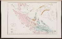
- Creator:
- Grange. J
- Call Number:
- 1998 995
- Collection Title:
- Voyage au pole sud et dans l'Oceanie sur les corvettes l'Astrolabe et la Zelee : execute par ordre
- Image Count:
- 1
- Found in:
- Beinecke Rare Book and Manuscript Library > Carte geologique de la Patagonie et de la terre de feu
- Call Number:
- 1977 +392
- Collection Title:
- A survey of the cities of London and Westminster : containing the original, antiquity, increase
- Image Count:
- 1
- Resource Type:
- Maps, Atlases & Globes
- Found in:
- Beinecke Rare Book and Manuscript Library > Cheape Ward with its division into parishes, taken from the last survey, with corrections and additions
- Call Number:
- 1977 +392
- Collection Title:
- A survey of the cities of London and Westminster : containing the original, antiquity, increase
- Image Count:
- 1
- Resource Type:
- Maps, Atlases & Globes
- Found in:
- Beinecke Rare Book and Manuscript Library > Coleman Street Ward and Bashishaw Ward taken from the last survey, with corrections and additions
- Creator:
- Jaillot, Alexis Hubert, 1632?-1712
- Published / Created:
- 1692
- Call Number:
- 1984 Folio 3
- Collection Title:
- Atlas nouveau : contenant toutes les parties du monde ou sont exactement remarques les empires
- Image Count:
- 1
- Resource Type:
- Maps, Atlases & Globes
- Found in:
- Beinecke Rare Book and Manuscript Library > Comte de Namur dresse sur les memoirs les plus nouveaux presente a sa Majeste pour le service de ses troupes par le service de ses troupes par le service de ses troupes ...
- Creator:
- Doolittle, Amos, 1754-1832
- Published / Created:
- 1795
- Call Number:
- 1973 Folio 27
- Collection Title:
- The general atlas for Careys edition of Guthries Geography improved ...
- Image Count:
- 1
- Found in:
- Beinecke Rare Book and Manuscript Library > Connecticut from the best authorities
- Call Number:
- 1977 +392
- Collection Title:
- A survey of the cities of London and Westminster : containing the original, antiquity, increase
- Image Count:
- 1
- Resource Type:
- Maps, Atlases & Globes
- Found in:
- Beinecke Rare Book and Manuscript Library > Cornhill Ward with its division into parishes, taken from the last survey &c
- Call Number:
- 1977 +392
- Collection Title:
- A survey of the cities of London and Westminster : containing the original, antiquity, increase
- Image Count:
- 1
- Resource Type:
- Maps, Atlases & Globes
- Found in:
- Beinecke Rare Book and Manuscript Library > Cow Cross being St. Sepulcher's parish without and the Charter House taken from the last survey with corrections
- Creator:
- Jefferys, Thomas, d. 1771.
Keulen, Gerard van
- Published / Created:
- 1775 Feb 20
- Call Number:
- 1973 Folio 80
- Collection Title:
- The West-India atlas: or, A compendious description of the West-Indies: illustrated with forty
- Image Count:
- 1
- Resource Type:
- Prints & Photographs
- Found in:
- Beinecke Rare Book and Manuscript Library > Curacao from the Dutch originals of Gerard Van Keulen
- Published / Created:
- [1596]
- Call Number:
- Taylor 192 4-6
- Collection Title:
- Americae pars sexta, sive, Historiae ab Hieronymo Be[n]zono Mediolane[n]se scriptae, sectio tertia
- Image Count:
- 1
- Found in:
- Beinecke Rare Book and Manuscript Library > Cvscho urbs nobilissima, & opulentissima Peruani regni in occidentali parte site in qua habitabat magnus ille Rex Atabali ...
- Creator:
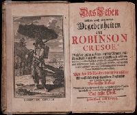
- Defoe, Daniel, 1661?-1731
- Published / Created:
- 1720
- Call Number:
- Defoe 52 n720e
- Image Count:
- 14
- Resource Type:
- Books, Journals & Pamphlets
- Found in:
- Beinecke Rare Book and Manuscript Library > Das Leben und die gantz ungemeine Begebenheiten des Robinson Crusoe ...
- Creator:
- Keulen, Gerard van
Keulen, Johannes van.
Marre, Jan de, 1696-1763.
Vooght, Claes Janszoon, d. 1696.
- Call Number:
- 1973 Folio 103
- Collection Title:
- De Nieuwe groote lichtende zee-fakkel ...
- Image Count:
- 1
- Resource Type:
- Maps, Atlases & Globes
- Found in:
- Beinecke Rare Book and Manuscript Library > De Oostin-dische zee / Het Eyland Mayota
- Call Number:
- 1971 Folio 601
- Collection Title:
- Description de lEgypte, ou, Recueil de observations et des recherches qui ont ete faites en Egypte
- Image Count:
- 1
- Found in:
- Beinecke Rare Book and Manuscript Library > Denderah. (Tentyris). pl. 18
- Call Number:
- 1971 Folio 601
- Collection Title:
- Description de lEgypte, ou, Recueil de observations et des recherches qui ont ete faites en Egypte
- Image Count:
- 1
- Found in:
- Beinecke Rare Book and Manuscript Library > Denderah. (Tentyris). pl. 30
- Creator:
- Keulen, Gerard van
Keulen, Johannes van.
Marre, Jan de, 1696-1763.
Vooght, Claes Janszoon, d. 1696.
- Call Number:
- 1973 Folio 103
- Collection Title:
- De Nieuwe groote lichtende zee-fakkel ...
- Image Count:
- 1
- Resource Type:
- Maps, Atlases & Globes
- Found in:
- Beinecke Rare Book and Manuscript Library > Des rivier legt op de Hoogte von 18 Graaden Zuyder Breedte aan het Land van de Megosie ter Kuste van Quama / Noord kust van't eyland ...
- Call Number:
- 1975 +1
- Collection Title:
- L'isole piv famose del mondo descritte da Thomaso Porcacchi da Castiglione Arretino e intagliate da
- Image Count:
- 1
- Resource Type:
- Maps, Atlases & Globes
- Found in:
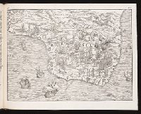
- Beinecke Rare Book and Manuscript Library > Descrittione dell' isola Cuba
- Call Number:
- 1974 +188
- Collection Title:
- L'isole piv famose del mondo descritte da Thomaso Porcacchi da Castiglione Arretino e intagliate da
- Image Count:
- 1
- Resource Type:
- Maps, Atlases & Globes
- Found in:
- Beinecke Rare Book and Manuscript Library > Descrittione dell' isola Cuba
- Call Number:
- 1974 +188
- Collection Title:
- L'isole piv famose del mondo descritte da Thomaso Porcacchi da Castiglione Arretino e intagliate da
- Image Count:
- 1
- Resource Type:
- Maps, Atlases & Globes
- Found in:
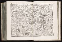
- Beinecke Rare Book and Manuscript Library > Descrittione dell' isola Spagnuola
- Call Number:
- 1976 +310
- Collection Title:
- L'isole piv famose del mondo descritte da Thomaso Porcacchi da Castiglione Arretino e intagliate da
- Image Count:
- 1
- Resource Type:
- Maps, Atlases & Globes
- Found in:
- Beinecke Rare Book and Manuscript Library > Descrittione dell'isola Cuba
- Call Number:
- 1985 +31
- Collection Title:
- L'isole piu famose del mondo / descritte da Thomaso Porcacchi da Castiglione Arretino e intagliate
- Image Count:
- 1
- Resource Type:
- Maps, Atlases & Globes
- Found in:
- Beinecke Rare Book and Manuscript Library > Descrittione dell'isola Cuba, che dal Colombo fu scoperta insieme con la Spagnuloa
- Call Number:
- 1975 +1
- Collection Title:
- L'isole piv famose del mondo descritte da Thomaso Porcacchi da Castiglione Arretino e intagliate da
- Image Count:
- 1
- Resource Type:
- Maps, Atlases & Globes
- Found in:
- Beinecke Rare Book and Manuscript Library > Descrittione dell'isola Spagnuola
- Call Number:
- 1976 +310
- Collection Title:
- L'isole piv famose del mondo descritte da Thomaso Porcacchi da Castiglione Arretino e intagliate da
- Image Count:
- 1
- Resource Type:
- Maps, Atlases & Globes
- Found in:
- Beinecke Rare Book and Manuscript Library > Descrittione dell'isola Spagnuola
- Call Number:
- 1985 +31
- Collection Title:
- L'isole piu famose del mondo / descritte da Thomaso Porcacchi da Castiglione Arretino e intagliate
- Image Count:
- 1
- Resource Type:
- Maps, Atlases & Globes
- Found in:
- Beinecke Rare Book and Manuscript Library > Descrittione dell'isola Spagnuola prima iso la scoperta dal Colombo
- Call Number:
- 1977 +246
- Collection Title:
- Geografia; cioè, Descrittione vniversale della terra. Partita in due volumi, nel primo de' quali si
- Image Count:
- 1
- Resource Type:
- Books, Journals & Pamphlets
- Found in:
- Beinecke Rare Book and Manuscript Library > Descrittione dell-America, o dell'India Occidentale. America
- Call Number:
- 1977 +246
- Collection Title:
- Geografia; cioè, Descrittione vniversale della terra. Partita in due volumi, nel primo de' quali si
- Image Count:
- 1
- Resource Type:
- Maps, Atlases & Globes
- Found in:
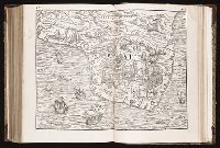
- Beinecke Rare Book and Manuscript Library > Descrittione di tvtto'l mondo, secondo la prattica de Marinari. Vniversi orbis descriptio ad vsvm navigantivm
- Call Number:
- 1977 +392
- Collection Title:
- A survey of the cities of London and Westminster : containing the original, antiquity, increase
- Image Count:
- 1
- Resource Type:
- Maps, Atlases & Globes
- Found in:
- Beinecke Rare Book and Manuscript Library > Farington Ward without, with its divisions into parishes, taken from the last survey with corrections & amendments
- Creator:
- Clark, William, 1770-1838
- Published / Created:
- [ca. 1814]
- Call Number:
- Zc10 814Le
- Collection Title:
- History of the expedition under the command of Captains Lewis and Clark, to the sources of the
- Image Count:
- 1
- Resource Type:
- Maps, Atlases & Globes
- Found in:
- Beinecke Rare Book and Manuscript Library > Fortification