Search
You Searched For
Search Results
- Creator:
- Moll, Herman, d. 1732
- Published / Created:
- [178-?]
- Call Number:
- 1973 Folio 113
- Image Count:
- 2
- Resource Type:
- Maps, Atlases & Globes
- Found in:
- Beinecke Rare Book and Manuscript Library > Atlas minor: or A new and curious set of sixty two maps, in which are shewn all the empires, kingdoms, countries, states in all the known parts of the earth ... by Herman Moll ...
- Creator:
- Moll, Herman, d. 1732
- Published / Created:
- [1732]
- Call Number:
- E1015 M66 1732
- Image Count:
- 1
- Found in:
- Beinecke Rare Book and Manuscript Library > Atlas minor: or a set of sixty-two new and correct maps, of all parts of the world. All composed and done by Herman Moll, geographer ...
- Creator:
- Moll, Herman, d. 1732
- Published / Created:
- 17--]
- Call Number:
- 1978 47
- Collection Title:
- Atlas minor.
- Image Count:
- 1
- Found in:
- Beinecke Rare Book and Manuscript Library > The Island of St. Christophers By Her. Moll Geographer
- Creator:
- Moll, Herman, d. 1732
- Published / Created:
- [1732]
- Call Number:
- E1015 M66 1732
- Collection Title:
- Atlas minor: or a set of sixty-two new and correct maps, of all parts of the world. All composed
- Image Count:
- 1
- Found in:
- Beinecke Rare Book and Manuscript Library > The Island of St. Christophers, alias St. Kitts By H. Moll Geographer
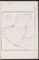
- Call Number:
- CC68 21
- Collection Title:
- Views of ancient monuments in Central America : Chiapas and Yucatan / by F. Catherwood ...
- Image Count:
- 1
- Found in:
- Beinecke Rare Book and Manuscript Library > Outline map of Central America and Yucatan showing the situation of the ruined cities & monuments
- Call Number:
- CE143 A28
- Collection Title:
- An account of the Spanish settlements in America. In four parts ... To which is annexed, a succinct
- Image Count:
- 1
- Found in:
- Beinecke Rare Book and Manuscript Library > A New general map of America drawn from several accurate particular maps and charts and regulated by astronomical observations
- Creator:
- Dunn, Samuel
- Published / Created:
- 1774
- Call Number:
- Cb23 27
- Collection Title:
- The American military pocket atlas : being an approved collection of correct maps, both general and
- Image Count:
- 1
- Found in:
- Beinecke Rare Book and Manuscript Library > North America as divided amongst the European powers
- Published / Created:
- 1776
- Call Number:
- Cb23 27
- Collection Title:
- The American military pocket atlas : being an approved collection of correct maps, both general and
- Image Count:
- 1
- Found in:
- Beinecke Rare Book and Manuscript Library > A General map of the northern British colonies in America. which comprehends the province of Quebec, the government of Newfoundland, Nova-Scotia, New-England and New-York. From the maps published by the Admiralty and Board of Trade regulated by the astronomic and trigonometric observations of M. von Holland and corrected from Governor Pownall's late map 1776.
- Published / Created:
- 1776
- Call Number:
- Cb23 27
- Collection Title:
- The American military pocket atlas : being an approved collection of correct maps, both general and
- Image Count:
- 1
- Found in:
- Beinecke Rare Book and Manuscript Library > A general map of the middle British colonies in America. Containing Virginia, Maryland, the Delaware counties, Pennsylvania and New Jersey. With the addition of New York, and of the greatest part of New England, as also of the bordering parts of the province of Quebec, improved from several surveys made after the late war, and corrected from Governor Pownall's late map 1776.
- Creator:
- Romans, B
- Published / Created:
- 1776
- Call Number:
- Cb23 27
- Collection Title:
- The American military pocket atlas : being an approved collection of correct maps, both general and
- Image Count:
- 1
- Found in:
- Beinecke Rare Book and Manuscript Library > A General map of the southern British colonies, in America, comprehending North and South Carolina, Georgia, east and west Florida, with the neighbouring Indian countries. From the modern surveys of engineer de Brahm, Capt. Collet, Mouzon & others; and from the large hydrographical survey of the coasts of east and west Florida