Skip to search
Skip to main content
Skip to first result
Search
You Searched For
Format
cartographic
Genre
Lithographs
New Search
Search Results
Creator:
Call Number:
Zc50 858be
Collection Title:
Wagon road from Fort Defiance to the Colorado River. Letter from the Secretary of War, transmitting
Image Count:
1
Found in:
Beinecke Rare Book and Manuscript Library > Preliminary map of the western portion of the reconnaissance & survey for a Pacific rail road route near the 35th par[allel] ...
Creator:
Published / Created:
1832
Call Number:
1978 Folio 106
Collection Title:
Maps of the Orinoco-Essequibo region, South America. Compiled for the Commission appointed by the
Image Count:
1
Resource Type:
Maps, Atlases & Globes
Found in:
Beinecke Rare Book and Manuscript Library > Part of a map of Colombia by J. Arrowsmith, London, 1832
Creator:
Published / Created:
1836
Call Number:
1992 230
Image Count:
1
Resource Type:
Books, Journals & Pamphlets
Found in:
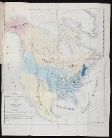
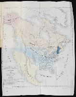
Beinecke Rare Book and Manuscript Library > Mapa para la obra intitulada De la Democracia en America por A. de Tocqueville
Creator:
Published / Created:
1836
Call Number:
1997 876
Collection Title:
De la democracia en la America del Norte / por Alejo de Tocqueville, abogado de la real audiencia
Image Count:
1
Resource Type:
Books, Journals & Pamphlets
Found in:
Beinecke Rare Book and Manuscript Library > Mapa para la obra intitulada De la Democracia en America por A. de Tocqueville
Creator:
Published / Created:
[1840]
Call Number:
1973 Folio 105
Collection Title:
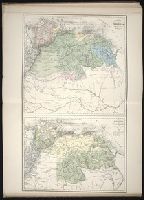
Atlas fisico y politico de la Republica de Venezuela ... por ... Agustin Codazzi ...
Image Count:
1
Resource Type:
Maps, Atlases & Globes
Found in:
Beinecke Rare Book and Manuscript Library > Mapa fisico de Venezuela, divida en hoyas hydrograficas.
Creator:
Published / Created:
[1840]
Call Number:
1973 Folio 105
Collection Title:
Atlas fisico y politico de la Republica de Venezuela ... por ... Agustin Codazzi ...
Image Count:
1
Resource Type:
Maps, Atlases & Globes
Found in:
Beinecke Rare Book and Manuscript Library > Mapa de las costas de Tierra-Firme desde el Orinoco hasta Yucatan: de las islas Antillas y la mayor parte de las Lucayas, con las derrotas que siguio Dn. Cristobal Colon en sus descubrimientos por estos mares y las derrotas de otros navegantes que reconoc
Creator:
Call Number:
Zc10 845fr
Collection Title:
Report of the exploring expedition to the Rocky Mountains in the year 1842, and to Oregon and north
Image Count:
1
Found in:
Beinecke Rare Book and Manuscript Library > Map of an exploring expedition to the Rocky Mountains in the year 1842, and to Oregon & North California in the years 1843-44
Creator:
Call Number:
A52 030 1
Collection Title:
Ancient monuments of the Mississippi Valley: comprising the results of extensive original surveys
Image Count:
1
Found in:
Beinecke Rare Book and Manuscript Library > Map of a section of twelve miles of the Scioto Valley with its ancient monuments, Pl. II [2]
Call Number:
Zc10 846sa
Collection Title:
Scenes in the Rocky Mountains, and in Oregon, California, New Mexico, Texas, and the grand prairies
Image Count:
1
Found in:
Beinecke Rare Book and Manuscript Library > Map of Oregon, California, New Mexico, N.W. Texas, & the proposed territory of Ne_Bras_Ka
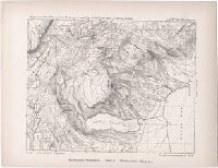
Published / Created:
1873-1884
Call Number:
WA Prints 189
Container / Volume:
Report upon United States Geographical surveys west of the one hundredth meridian in charge of First Lieut. Geo. M. Wheeler ... (Washington, Govt. Print. Off., 1875-1879).
Image Count:
1
Found in:
Beinecke Rare Book and Manuscript Library > Main-route and side meanders, and topographical stations. Form 3
Creator:
Published / Created:
1850
Call Number:
1975 Folio 26
Collection Title:
A new universal atlas containing maps of the various empires, kingdoms, states and republics of the
Image Count:
1
Resource Type:
Maps, Atlases & Globes
Found in:
Beinecke Rare Book and Manuscript Library > Lengths of the principal rivers in the world
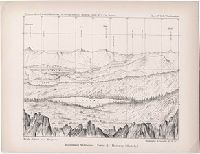
Published / Created:
1873-1884
Call Number:
WA Prints 187
Container / Volume:
Report upon United States Geographical surveys west of the one hundredth meridian in charge of First Lieut. Geo. M. Wheeler ... (Washington, Govt. Print. Off., 1875-1879).
Image Count:
1
Found in:
Beinecke Rare Book and Manuscript Library > Horizontal sketch from Tallac Peak, Cal. Occupied. Oct. 14, 1876 by Party No. 2, Cal. Section. Inst. No. 160. Wurdemann. Mountain Stations. Form 1. (Horizontal sketch)
Published / Created:
1873-1884
Call Number:
WA Prints 188
Container / Volume:
Report upon United States Geographical surveys west of the one hundredth meridian in charge of First Lieut. Geo. M. Wheeler ... (Washington, Govt. Print. Off., 1875-1879).
Image Count:
1
Found in:
Beinecke Rare Book and Manuscript Library > Horizon sketch from Tallac Peak, Cal. Occupied. Oct. 14, 1876 by Party No. 2, Cal. Section. Inst. No. 160. Wurdemann. Mountain Stations. Form 2. (Horizontal sketch.)
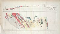
Published / Created:
ca. 1855
Call Number:
WA Prints +3
Container / Volume:
Report of explorations for railroad routes from San Francisco Bay to Los Angeles...and from the Pimas Villages to the Rio Grande...by Lieutenant John G. Parke 1854-1855. Volume VII from Reports of explorations and surveys, to ascertain the most practicab
Image Count:
1
Found in:
Beinecke Rare Book and Manuscript Library > Geological plan of the coast range of California from San Francisco bay to Los Angeles along the route explored by Lieut. John G. Parke, corps of topl. Engrs. To connect with the routes near the 35o & 32o parallels of north latitude. 1855-56. Prepared to
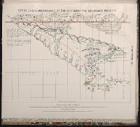
Published / Created:
ca. 1855
Call Number:
WA Prints +4
Container / Volume:
Report of explorations for railroad routes from San Francisco Bay to Los Angeles...and from the Pimas Villages to the Rio Grande...by Lieutenant John G. Parke 1854-1855. Volume VII from Reports of explorations and surveys, to ascertain the most practicab
Image Count:
1
Found in:
Beinecke Rare Book and Manuscript Library > Geological Plan & Section from Rio Grande to the Pimas Villages along the route explored by Lieut. John G. Parke, Corps of Topl. Engrs. near the 32o north latitude. 1856. Prepared to accompany the report of Thomas Antiselol M.D. geologist of the expediti
Published / Created:
[15--]
Call Number:
1978 Folio 106
Collection Title:
Maps of the Orinoco-Essequibo region, South America. Compiled for the Commission appointed by the
Image Count:
1
Resource Type:
Maps, Atlases & Globes
Found in:
Beinecke Rare Book and Manuscript Library > Early Spanish map of Guiana
Creator:
Published / Created:
[1887]
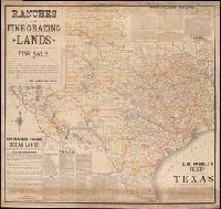
Call Number:
BrSides Elephant Folio Zc52 887ra
Image Count:
1
Resource Type:
Maps, Atlases & Globes
Found in:
Beinecke Rare Book and Manuscript Library > E.M. Powell's map of the state of Texas.
Creator:
Published / Created:
[1840]
Call Number:
1973 Folio 105
Collection Title:
Atlas fisico y politico de la Republica de Venezuela ... por ... Agustin Codazzi ...
Image Count:
1
Resource Type:
Maps, Atlases & Globes
Found in:
Beinecke Rare Book and Manuscript Library > Carta del Canton de Upata de la provincia de la Guayana
Creator:
Published / Created:
[1840]
Call Number:
1973 Folio 105
Collection Title:
Atlas fisico y politico de la Republica de Venezuela ... por ... Agustin Codazzi ...
Image Count:
1
Resource Type:
Maps, Atlases & Globes
Found in:
Beinecke Rare Book and Manuscript Library > Carta del Canton de Angostura de la provincia de la Guayana
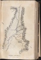
Creator:
Call Number:
Zc10 845fr
Collection Title:
Report of the exploring expedition to the Rocky Mountains in the year 1842, and to Oregon and north
Image Count:
1
Found in:
Beinecke Rare Book and Manuscript Library > Beer Springs
Branch:v1.60.98 ,Deployed:2024-04-24T10:14:36-04:00