The discovery, settlement, and present state of Kentucky: and an essay towards the topography and
Image Count:
1
Description:
Engrav'd for S. Campbell's Edition of Imlay's Description of Kentucky., Preceding title page., and Teaching resource: Professor John Mack Faragher, History 141: The American West.
Subject (Geographic):
Kentucky --Maps --Early works to 1800 and Ohio River Valley
Chandos, James Brydges, Duke of, 1674-1744 Mayo, William., creator Senex, John, d. 1740
Published / Created:
1722
Call Number:
2003 Folio 85
Image Count:
1
Alternative Title:
New and exact map of the island of Barbadoes in America
Description:
BEIN 2003 Folio 85: No. 39 of 45 maps bound together with binder's spine title: Atlas of America; ms. table of contents. Bookplate: Robinson. Bookplate of Paul Mellon., by William Mayo., Cartouche with dedication to: The most high, puissant & noble prince, Iames Bruges, Duke of Chandos., Cartouche, Explanation, includes Contents of the parishes., Engraved by Iohn Senex, 1722., Hand colored., Insets: A plan of the Bridge town; A prospect of Codrington College &c., Relief shown pictorially., and Scale [ca. 1:33,000].
The English pilot: describing the West-India navigation, from Hudson's-Bay to the river Amazones
Image Count:
1
Resource Type:
Maps, Atlases & Globes
Subject (Geographic):
Atlantic Ocean --Maps --Early works to 1800, Cuba --Maps --Early works to 1800, Matanzas Bay (Cuba) --Maps --Early works to 1800, and West Indies --Maps --Early works to 1800
Subject (Topic):
Navigation --Early works to 1800, Pilot guides --Atlantic Coast (U.S.) --Early works to 1800, and Pilot guides --Caribbean Area --Early works to 1800
Collection Created:
London : Printed for W. and J. Mount, T. Page and son, on Tower-Hill, MDCCLIX [1759]
The English pilot: describing the West-India navigation, from Hudson's-Bay to the river Amazones
Image Count:
1
Subject (Geographic):
Atlantic Ocean --Maps --Early works to 1800, Cuba --Maps --Early works to 1800, Matanzas Bay (Cuba) --Maps --Early works to 1800, and West Indies --Maps --Early works to 1800
Subject (Topic):
Navigation --Early works to 1800, Pilot guides --Atlantic Coast (U.S.) --Early works to 1800, and Pilot guides --Caribbean Area --Early works to 1800
Map of the world showing routes of Cook's expeditions, with notes on ice, wild life etc. seen. Relief shown pictorially; imaginary coastline for eastern coast of Australian Bight., No. 1 of 43 maps bound together in composite atlas., and Scale [ca.1:68 000 000].
Publisher:
Published by Wm. Faden, Geographer to the King, Charing Cross
Subject (Name):
Cook, James, 1728-1779 and Mulgrave, Constantine John Phipps, Lord
Subject (Topic):
Discoveries in geography --Maps --To 1800 and World maps --Early works to 1800
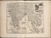
Bar scales given in English miles, 60 in a degree, Irish miles, 50 in a degree, and Dutch miles, 15 in a degree., Drawn from the survey made by Sr. Wm. Petty ; divided into its provinces, counties, and barronies, shewing also its bishopricks, borroughs, highwaies ... ; improved with many additions not extent in any other map., Includes inset map The sea coast of England, Scotland, and Ireland, Holland & part of France., No. 8 of 69 maps bound together in composite atlas., and Scale [ca. 1:540 000].
Publisher:
Sold by Rob. Morden at the Atlas in Corn-hil and by Christ. Brown at the Globe and Compasses in St. Pauls Churchyard
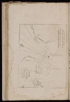
BEIN 2003 Folio 85: No. 31 of 45 maps bound together with binder's spine title: Atlas of America; ms. table of contents. Bookplate: Robinson. Bookplate of Paul Mellon., Hand colored., Includes inset A general plan of Port Royal, in which the different states of the town are accurately laid down, ca. 1:3,200., Relief shown pictorially. Soundings shown in fathoms., Scale [ca. 1:420,000]., and the greatest part drawn or corrected from actual surveys made by Mr. Sheffield and others.
Publisher:
Printed for John Bowles ... and Carington Bowles
Subject (Geographic):
Jamaica -- Maps -- Early works to 1800 and Port Royal (Jamaica) -- Maps -- Early works to 1800