Skip to search
Skip to main content
Skip to first result
Search
You Searched For
Format
cartographic
Genre
Maps.
Search Results
Creator:
Published / Created:
1755
Call Number:
783 1755F
Container / Volume:
BRBL_00507
Image Count:
1
Resource Type:
Maps, Atlases & Globes
Description:
A textual note at upper left reads "The Course of the Ohio or Alliganey River and its Branches are laid down from Surveys and Draughts made on the Spot by M.r Gist and others in the Years 1751, 2, 3 & 4".
Publisher:
Thomas Jefferys,
Subject (Geographic):
Maryland--Maps--Early works to 1800., Middle Atlantic States--Maps--Early works to 1800., and Virginia--Maps--Early works to 1800.
Subject (Name):
Byrd, William, 1674-1744., Churton, William, 1710-1767, surveyor., Dalrymple, John, -1766, surveyor., Dandridge, William, -1743., Fitzwilliam, Richard, -1744., and Fry, Joshua, approximately 1700-1754, ca
Found in:
Beinecke Rare Book and Manuscript Library > A map of the most inhabited part of Virginia containing the whole province of Maryland with part of Pensilvania, New Jersey and North Carolina / drawn by Joshua Fry & Peter Jefferson in 1751.
Creator:
Published / Created:
[1765?]
Call Number:
2017 Folio 49
Image Count:
1
Resource Type:
Maps, Atlases & Globes
Alternative Title:
New and accurate map of Germany including the seat of war in the Kingdom of Prussia, Bohemia, Lusatia, Silesia, Saxony, Westphalia
Description:
Prime meridian: London. Coordinates converted by cataloger to express longitude as measured from the Greenwich meridian.
Publisher:
[Robert Sayer]
Subject (Geographic):
Germany--Maps--Early works to 1800.
Subject (Name):
Sayer, Robert, 1725-1794, publisher.
Found in:
Beinecke Rare Book and Manuscript Library > A new & accurate map of Germany including the seat of war in the Kingdom of Prussia, Bohemia, Lusatia, Silesia, Saxony, Westphalia &c. : also an exact table of the distances in German & English miles from town to town / by R. Bennett, engraver.
Creator:
Published / Created:
[1747]
Call Number:
655 1747
Container / Volume:
BRBL_00345
Image Count:
1
Resource Type:
Maps, Atlases & Globes
Alternative Title:
New and accurate map of Negroland and the adjacent countries
Description:
Includes decorative title cartouche with figures.
Publisher:
[Emanuel Bowen],
Subject (Geographic):
Africa, West--Maps--Early works to 1800.
Found in:
Beinecke Rare Book and Manuscript Library > A new & accurate map of Negroland and the adjacent countries : also Upper Guinea, shewing the principal European settlements, & distinguishing w[hi]ch belong to England, Denmark, Holland &c., the sea coast & some of the rivers being drawn from surveys & t
Creator:
Published / Created:
1911-12 [i.e. 1911?], and c1911.
Call Number:
811 D48 1911
Container / Volume:
BRBL_00553
Image Count:
1
Resource Type:
Maps, Atlases & Globes
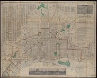
Alternative Title:
Detroit and suburbs
Description:
Includes "Something about Detroit" list, ill., and street index.
Publisher:
Silas Farmer & Co.,
Subject (Geographic):
Detroit (Mich.)--Maps. and Detroit Metropolitan Area (Mich.)--Maps.
Subject (Topic):
Streets--Michigan--Detroit Metropolitan Area--Maps. and Streets--Michigan--Detroit--Maps.
Found in:
Beinecke Rare Book and Manuscript Library > A new map of Detroit and suburbs : includes River Rouge, Oakwood, Highland Park, Hamtramck, St. Clair Heights, and Grosse Pointe.
Creator:
Published / Created:
12th May 1794.
Call Number:
71 1794P
Container / Volume:
BRBL_00726
Image Count:
2
Resource Type:
Maps, Atlases & Globes
Description:
Copy 2: Imperfect: two southern sheets wanting. Borders hand colored. Dissected and mounted on linen, 50 x 115 cm. Stamp on verso, "Yale University Library, Karpinski-Von Wieser Map Collection."
Publisher:
Publish'd by Laurie & Whittle, No. 53 Fleet Street,
Subject (Geographic):
North America--Maps--Early works to 1800.
Subject (Name):
Brown, Horace--Stamp. and Laurie & Whittle
Subject (Topic):
British--America--Maps--Early works to 1800.
Found in:
Beinecke Rare Book and Manuscript Library > A new map of North America with the West India Islands : divided according to the preliminary articles of peace, signed at Versailles, 20 Jan. 1783, wherein are particularly distinguished the United States, and the several provinces, governments &ca which
Creator:
Published / Created:
12th May 1794.
Call Number:
71 1794P
Container / Volume:
BRBL_00726
Image Count:
2
Resource Type:
Maps, Atlases & Globes
Description:
Copy 1: two northern sheets joined and two southern sheets joined. Borders hand colored. Stamps, "Yale, Horace Brown, 1900S."
Publisher:
Publish'd by Laurie & Whittle, No. 53 Fleet Street,
Subject (Geographic):
North America--Maps--Early works to 1800.
Subject (Name):
Brown, Horace--Stamp. and Laurie & Whittle
Subject (Topic):
British--America--Maps--Early works to 1800.
Found in:
Beinecke Rare Book and Manuscript Library > A new map of North America with the West India Islands : divided according to the preliminary articles of peace, signed at Versailles, 20 Jan. 1783, wherein are particularly distinguished the United States, and the several provinces, governments &ca which
Creator:
Published / Created:
12th May 1794.
Call Number:
71 1794P
Container / Volume:
BRBL_00726
Image Count:
2
Resource Type:
Maps, Atlases & Globes
Description:
Copy 3: Interiors hand colored. Stamp on verso of northern sheets: 37. Stamp on verso of southern sheets: 38.
Publisher:
Publish'd by Laurie & Whittle, No. 53 Fleet Street,
Subject (Geographic):
North America--Maps--Early works to 1800.
Subject (Name):
Brown, Horace--Stamp. and Laurie & Whittle
Subject (Topic):
British--America--Maps--Early works to 1800.
Found in:
Beinecke Rare Book and Manuscript Library > A new map of North America with the West India Islands : divided according to the preliminary articles of peace, signed at Versailles, 20 Jan. 1783, wherein are particularly distinguished the United States, and the several provinces, governments &ca which
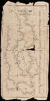
Creator:
Published / Created:
1845
Call Number:
80 1845A
Image Count:
1
Resource Type:
Maps, Atlases & Globes
Alternative Title:
Travellers guide
Description:
"Engraved according to act of Congress in the year 1842 by Saml. B. Munson ..."
Publisher:
Published by Geo. Conclin,
Subject (Geographic):
Illinois River--Maps., Mississippi River--Maps., Missouri River--Maps., and Ohio River--Maps.
Subject (Name):
Doolittle & Munson
Found in:
Beinecke Rare Book and Manuscript Library > A new map of the western rivers, or, Travellers guide : exhibiting the Mississippi, Missouri, Ohio, and Illinois rivers with all the principal towns, islands & distances / by Saml. B. Munson.
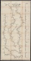
Creator:
Published / Created:
1844
Call Number:
807 1844
Image Count:
1
Resource Type:
Maps, Atlases & Globes
Alternative Title:
Travellers guide
Description:
"Engraved by Thos. Twichell for Doolittle & Munson."
Publisher:
Doolittle & Munson,
Subject (Geographic):
Illinois River (Ill.)--Maps., Mississippi River--Maps., Missouri River--Maps., and Ohio River--Maps.
Subject (Name):
Doolittle & Munson, publisher. and Twichell, Thos. (Thomas), engraver.
Found in:
Beinecke Rare Book and Manuscript Library > A new map of the western rivers, or, Travellers guide : exhibiting the Mississippi, Missouri, Ohio, and Illinois rivers with all the principal towns, islands & distances / by Saml. B. Munson.
Creator:
Call Number:
Lanman 50 1676
Image Count:
2
Resource Type:
Maps, Atlases & Globes
Alternative Title:
New map of Tartary
Description:
English text on verso entitled: The description of the kingdom of Tartary, p. 39-40 (signature: V).
Subject (Geographic):
Mongolia--Maps--Early works to 1800.
Subject (Name):
Bassett, Thomas, Chiswell, Richard, Gryp, Dirck, engraver, and Speed, John, 1552?-1629
Found in:
Beinecke Rare Book and Manuscript Library > A newe mape of Tartary / augmented by John Speed and are to be sold by Tho. Bassett in Fleet Street & Richard Chiswell in St. Pauls Churchyard ; Dirck Grÿp, sculp.