Skip to search
Skip to main content
Skip to first result
Search
You Searched For
Format
cartographic
Genre
Maps.
Search Results
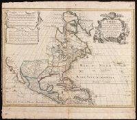
Creator:
Published / Created:
1777
Call Number:
755 1777B
Container / Volume:
BRBL_00431
Image Count:
1
Resource Type:
Maps, Atlases & Globes
Description:
Appears in various eds. of Atlas geographicus maior.
Publisher:
[s.n.],
Subject (Geographic):
North America--Maps--Early works to 1800. and United States--History--French and Indian War, 1755-1763--Maps--Early works to 1800.
Subject (Name):
Anville, Jean Baptiste Bourguignon d', 1697-1782. and Homann Erben (Firm). Atlas geographicus maior.
Found in:
Beinecke Rare Book and Manuscript Library > America Septentrionalis a Domino d'Anville in Galliis edita nunc in Anglia : coloniis in interiorem Virginiam deductis nec non Fluvii Ohio cursu aucta notisque geographicis et historicis illustrata et ad bellum praesentis temporis accomodata / sumptibus Homannianorum Heredum.
Creator:
Published / Created:
[1718]
Call Number:
BrSides Double Folio 2019 105
Image Count:
1
Resource Type:
Maps, Atlases & Globes
Description:
Includes five bar scales.
Publisher:
Venalis prostat Augustae Vindelic apud Jeremiam Wolff,
Subject (Geographic):
North America--Maps.
Subject (Name):
Karpinski, Louis Charles,--1878-1956--Ownership. and Wolf, Jeremias, 1663?-1724, pulbisher.
Found in:
Beinecke Rare Book and Manuscript Library > America septentrionalis : concinnata juxta observationes D[omi]n[o] n[ostro] Academiae Regalis Scientiarum et nonnullorum aliorum, et juxta annotationes recentissimas / par G. De L'Isle, geographum.
Creator:
Published / Created:
[1676?]
Call Number:
70 1676
Container / Volume:
BRBL_00354
Image Count:
2
Resource Type:
Maps, Atlases & Globes
Description:
From his atlas Prospect of the World, pp. 9-10, sig. e, catch. in-.
Publisher:
are to be sold by Thomas Bassett in Fleet Street and by Richard Chiswell in St. Pauls Churchyard,
Subject (Geographic):
America--Maps--Early works to 1800.
Subject (Name):
Bassett, Thomas, bookseller., Chiswell, Richard., Goos, Abraham, engraver., and Speed, John, 1552?-1629. Prospect of the most famous parts of the world.
Found in:
Beinecke Rare Book and Manuscript Library > America with those known parts in that unknowne worlde both people and manner of buildings / Discribed and inlarged by I.S. Ano 1626 ; Abraham Goos ... sculpsit.
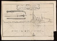
Published / Created:
[between 1743-1747?]
Call Number:
BrSides Folio 2017 20
Image Count:
1
Resource Type:
Maps, Atlases & Globes
Alternative Title:
New general collection of voyages and travels.
Description:
Coordinates not present on map and are approximated.
Publisher:
[publisher not identified],
Subject (Geographic):
Cross River State (Nigeria)--Maps--Early works to 1800.
Subject (Name):
Child, G., engraver. and Glasgow (Scotland). Public Libraries Stamp.
Subject (Topic):
Coasts--Nigeria--Calabar Province--Maps--Early works to 1800.
Found in:
Beinecke Rare Book and Manuscript Library > An accurate map of Kalbar River (commonly called Kalabar or Rio Real) and adjacent coast drawn on ye spot by several pilots, 1699 / G. Child, sculpt.
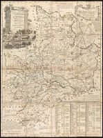
Creator:
Published / Created:
[1749]
Call Number:
2016 1346
Image Count:
1
Resource Type:
Maps, Atlases & Globes
Description:
Concentric rings at one mile intervals from Huntingdon.
Publisher:
[Emanuel Bowen?],
Subject (Geographic):
Huntingdonshire (England)--Early works to 1800--Maps.
Subject (Name):
Bowles, John, 1701-1779, publisher. and Hinton, John, -1781, bookseller.
Found in:
Beinecke Rare Book and Manuscript Library > An accurate map of the county of Huntingdon divided into its hundreds : drawn from surveys and illustrated with various additional improvements ; also historical extracts relating to its trade, manufactures, natural history &c. not extant in any other map
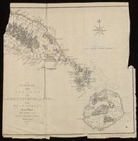
Published / Created:
[1782]
Call Number:
BrSides Folio 2017 24
Image Count:
1
Resource Type:
Maps, Atlases & Globes
Description:
"European Magazine" in upper right.
Publisher:
Published April 1, 1782, by I. Fielding, Pater noster Row, J. Sewell, Cornhill, and J. Debrett, Piccadilly,
Subject (Geographic):
Saint Kitts and Nevis--Maps--Early works to 1800.
Subject (Name):
Cary, John, approximately 1754-1835, engraver.
Found in:
Beinecke Rare Book and Manuscript Library > An accurate map of the islands of St. Christophers and Nevis in the West Indies / by an officer ; with the position of the English and French fleets, February 7th, 1782 ; J. Cary, sc.
Published / Created:
[1826]
Call Number:
BrSides Folio 2017 31
Image Count:
1
Resource Type:
Maps, Atlases & Globes
Description:
From Francesco Saverio Clavigero's Historia Antigua de Megico.
Publisher:
Publicado por el Sr. R. Ackermann en Londres y en Megico,
Subject (Geographic):
Mexico--Maps.
Subject (Name):
Clavigero, Francesco Saverio, 1731-1787. Storia antica del Messico. Spanish., Neele, Samuel John, 1758-1824, engraver., and South American Exploration Fund (Yale University) Ownership.
Found in:
Beinecke Rare Book and Manuscript Library > Anahuac o Imperio Megicano : con los Reinos de Acolhuacan y de Michuacan &c., como existan en el año de 1521, para servir de illustracion a la historia antigua de Megico / gravado por Neeles 352 Strand Londres.
Creator:
Published / Created:
[1757-1786?]
Call Number:
27 1750
Container / Volume:
BRBL_00023A
Image Count:
1
Resource Type:
Maps, Atlases & Globes
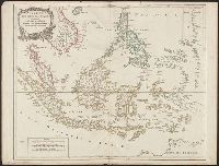
Description:
Covers present-day Indonesia, the Philippines, Malayan peninsula, Indo-Chinese peninsula, and north-west coast of Australia.
Publisher:
[publisher not identified],
Subject (Geographic):
Asia--East Indies, Australia--Maps--Early works to 1800., East Indies--Maps--Early works to 1800., Mariana Islands--Maps--Early works to 1800., and Southeast Asia--Maps--Early works to 1800.
Subject (Name):
Haye, G. de la, engraver. and Robert de Vaugondy, Gilles, 1688-1766. Atlas universel.
Found in:
Beinecke Rare Book and Manuscript Library > Archipel des Indes Orientales : qui comprend les Isles de la Sonde, Moluques et Philippines / tirʹees des Cartes du Neptune Oriental par le Sr. Robert ; Guill. Delahaye sculp.
Creator:
Published / Created:
1750
Call Number:
BrSides Double Folio 2017 6
Image Count:
1
Resource Type:
Maps, Atlases & Globes
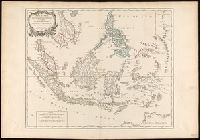
Description:
"Archipel des Indes" stamped twice on verso.
Publisher:
[publisher not identified],
Subject (Geographic):
Southeast Asia--Maps--Early works to 1800.
Subject (Name):
Haye, G. de la, engraver., Robert de Vaugondy, Didier, 1723-1786. Atlas Universel., and Robert de Vaugondy, Gilles, 1688-1766. Atlas universel.
Found in:
Beinecke Rare Book and Manuscript Library > Archipel des Indes Orientales qui comprend les isles de la Sonde, Moluques et Philippines [cartographic material] : tirées des cartes du Neptune oriental / par le Sr. Robert, Géographe ordinaire du Roy ; Guill. Delahaye sculp.
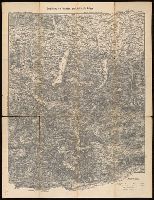
Creator:
Published / Created:
[between 1910 an 1919?]
Call Number:
424 1910
Container / Volume:
BRBL_00245
Image Count:
2
Resource Type:
Maps, Atlases & Globes
Alternative Title:
Touristen-karten im Massstabe von 1:129,600 and Umgebung von Gmunden, Ischl, Hallstadt, Aufsee
Description:
Imperfect: all sheets but sheet 2 wanting. "Uebersichtsblatt zu R. Maschek's Touristenkarte" pasted on verso.
Publisher:
Artaria & Comp.,
Subject (Geographic):
Austria--Maps.
Found in:
Beinecke Rare Book and Manuscript Library > Artaria's neueste Touristen-karten im Massstabe von 1:129,600.