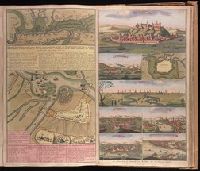
Accurate aftekening hoe de twee Legers geleegen hebben voor Belgrado, ent bomberderen en kanonneeren op malkanderen van den 2 tot den 14 Augustus anno 1717 and Nieuwe accurate kaart van de marse der Keyserlyke armee van Peter Wardien en Futak.
Description:
Backed with paper. Ms. no. in upper right corner [illegible due to trimming]. Sheet measures 53.8 x 62.4 cm. No. 74 of 87 maps bound together., On sheet with 1 other map ("Nieuwe accurate kaart van de marse der Keyserlyke armee van Peter Wardien en Futak ... tot voor Belgrado ... 9 tot den 19 Iuny anno 1717") and 7 bird's-eye views ("Belgrad," "Temeswar" [with map "De Stadt Temeswar"], "Temeswar" [2], "Wardien," "Offen v. Pest," "Sigeth," and "Citta e porto di Constantinopoli")., Relief shown pictorially., and With inset bird's-eye view of Belgrade in upper left corner.
Appeared in Valk and Schenk's Atlantis sylloge compendiosa, ca. 1702., Backed with paper. Ms. no. "61" in upper right-hand corner. Sheet measures 53.1 x 62.3 cm. No. 56 of 87 maps bound together., Bar scales given in "milliaria Gallica" and "milliaria Germanica.", Prime meridian: Ferro., and Relief shown pictorially.
Publisher:
Ger. et Leo. Valk,
Subject (Geographic):
Orléanais (France)--Maps--Early works to 1800.
Subject (Name):
Schenk, Peter, 1660-1718 or 1719. Atlantis sylloge compendiosa., Valck, G. (Gerard), 1651 or 1652-1726. Atlantis sylloge compendiosa., and Valck, Leonard, 1675-1746.
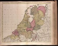
Appears in Valk and Schenk's Atlantis sylloge compendiosa, ca. 1702., Backed with paper. Ms. no. "40" in upper-right corner. Sheet measures 53.6 x 63.0 cm. No. 39 of 87 maps bound together., Bar scales given in "horae itinerissive milliaria Gallica" and "milliaria Germanica"., Prime meridian: Ferro., and Watermark.
Publisher:
Gerard Valk,
Subject (Geographic):
Netherlands--Maps--Early works to 1800.
Subject (Name):
Schenk, Peter, 1660-1718 or 1719. Atlantis sylloge compendiosa., Valck, G. (Gerard), 1651 or 1652-1726. Atlantis sylloge compendiosa., and Valck, Leonard, 1675-1746.
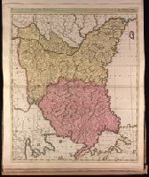
Appeared in Valk and Schenk's Atlantis sylloge compendiosa, ca. 1702., Backed with paper. Ms. no. "82" in upper left corner. Sheet measures 62.5 x 53.7 cm. No. 76 of 87 maps bound together., Bar scales given in "milliaria Hungarica" and "milliaria Germanica.", Prime meridian: Ferro., and Relief shown pictorially.
Publisher:
Gerard Valk,
Subject (Geographic):
Bulgaria--Maps--Early works to 1800., Romania--Maps--Early works to 1800., and Turkey--Maps--Early works to 1800.
Subject (Name):
Schenk, Peter, 1660-1718 or 1719. Atlantis sylloge compendiosa. and Valck, G. (Gerard), 1651 or 1652-1726. Atlantis sylloge compendiosa.
"Avec Privilege du Roi.", Insets: Map of territory west of Lake Superior; map of territory west of Florida; view of "Sault du Niagara, de 135 pieds de haut"., Relief shown pictorially., and Second state: contains two keys to colors "Couleur selon les pretentions des Anglois" and "Selon les pretentions de la France."
Publisher:
[Georges-Louis Le Rouge] Rue des Augustins,
Subject (Geographic):
Atlantic States--Maps--Early works to 1800., France--Colonies--America--Maps--Early works to 1800., Great Britain--Colonies--America--Maps--Early works to 1800., Maritime Provinces--Maps--Early works to 1800., and United States--History--French and Indian War, 1754-1763--Maps--Early works to 1800.
"Avec privilege du Roy.", "Se vend a Bruxelles chez Eugene Henry Fricx, imprimeur du Roy.", Includes "Avertissement.", Prime meridian: Ferro., Relief shown pictorially., and Shows east coast of Brazil.
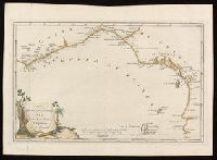
"P. II. 44" in upper right corner., From P. Santini's Atlas universel, 1784., Prime meridians: Paris; Ferro. Coordinates converted by cataloger to express longitude as measured from the Greenwich meridian., Relief shown pictorially., and This edition was issued in Venice for Francesco Santini and Giuseppi Antonio Remondini's reissue of De L'Isle's Atlas universel.
Subject (Geographic):
Bering Strait Region--Discovery and exploration--Russian--Maps--Early works to 1800., North America--Discovery and exploration--Russian--Maps--Early works to 1800., Pacific Coast (North America)--Discovery and exploration--Maps--Early works to 1800., and Russian Far East (Russia)--Discovery and exploration--Russian--Maps--Early works to 1800.
Subject (Name):
L'Isle, Guillaume de, 1675-1726., Remondini, Giuseppi Antonio, 1747-1811, publisher., and Santini, P. Atlas universel.