Map of the Northern Pacific Railroad, showing the intercontinental routes, oceanic currents and steamboat lines around the world. and Profiles of the Northern Pacific and the Central and Union Pacific Railroads, showing the difference in configuration of the country along the respective routes.
Description:
Imperfect: chipped along folds, with some loss of text. Backed with paper., Includes inset of "Map of the Northern Pacific Railroad, showing the intercontinental routes, oceanic currents and steamboat lines around the world," text, and "Profiles of the Northern Pacific and the Central and Union Pacific Railroads, showing the difference in configuration of the country along the respective routes.", Prime meridians: Greenwich and Washington., and Relief shown by hachures and spot heights.
Subject (Geographic):
NorthAmerica--Maps.
Subject (Name):
Northern Pacific Railroad Company--Maps.
Subject (Topic):
Railroads--Canada--Maps. and Railroads--United States--Maps.
2nd edition, 1st state, with entirely new plate from 1st edition that now shows all of Florida peninsula with title in cartouche., Below map is letterpress entitled: A compendious account of the British colonies in North America., Lower right corner of map includes Evan's polymetric table of America, with distances, and Thomas Templeman's survey of the size and area of the individual colonies., and Watermark.
Subject (Geographic):
NorthAmerica--Maps--Early works to
Subject (Name):
Jefferys, Thomas, -1771. and Robert Sayer and John Bennett (Firm)
Robert de Vaugondy, Gilles, 1688-1766, cartographer.
Call Number:
73 1785
Image Count:
1
Resource Type:
Maps, Atlases & Globes
Alternative Title:
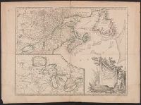
Partie de l'Amérique septent[rionale] qui comprend la Nouvelle France ou le Canada
Description:
Decorative title cartouche by Graux., Fourth state with date in cartouce removed., From the author's Atlas universel., Inset of "Supplement pour les lacs du Canada" (scale approximately 1:5,500,000)., Relief shown pictorially., and Watermark.
Subject (Geographic):
Great Lakes Region (NorthAmerica
Subject (Name):
Robert de Vaugondy, Gilles, 1688-1766. Atlas universel.