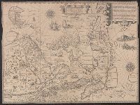
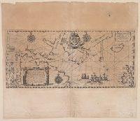
Exacta et accurata delineatis cum orarum maritimarum tum etjam locorum terrestrium and Waarachtige wtworpinghe ofte afbeeldinge van alle dje custen end landen
Description:
Appears in the author's Itinerario. 1596., Backed with paper., Has watermark., Includes ill., Latin and Dutch., Oriented with north to the left., and Relief shown pictorially.
Publisher:
C. Claesz,
Subject (Geographic):
Southeast Asia--Maps--Early works to 1800
Subject (Name):
Langren, Arnold Florent van, 1580-1644, Langren, Henricus F. ab (Henricus Florentius), ca. 1574-1648, engraver, Linschoten, Jan Huygen van, 1563-1611, and Linschoten, Jan Huygen van, 1563-1611. Itinerario, voyage ofte schipvae
Subject (Topic):
Nautical charts--South China Sea--Early works to 1800 and Nautical charts--Southeast Asia--Early works to 1800
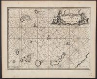
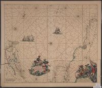
Ogilby, John, 1600-1676 Ogilby, John, 1600-1676. Africa, being an accurate description of the regions of Egypt, Barbary
Published / Created:
1670]
Call Number:
214 1670
Image Count:
1
Resource Type:
Maps, Atlases & Globes
Description:
Covers the Canary Islands and Madeira Islands., From Ogilby's Africa, being an accurate description of the regions of Egypt, Barbary, Lybia and Billedulgerid. 1, Has watermarks., Includes ill., rhumb lines, and decorative cartouche., and Relief shown pictorially.
Publisher:
Printed by T. Johnson for the author,
Subject (Geographic):
Canary Islands--Maps--Early works to 1800 and Madeira Islands--Maps--Early works to 1800
Subject (Topic):
Nautical charts--Canary Islands--Early works to 1800 and Nautical charts--Madeira Islands--Early works to 1800
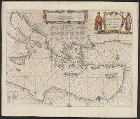
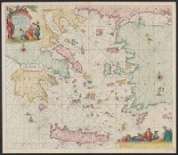
"Met priviligie voor 15 Iaar.", Appears in the author's De groote niewe vermeerderde zee-atlas ofte water-waereld., Dutch, with Latin place names., Has watermark., and Includes col. ill., decorative cartouche, and rhumb lines.
Publisher:
By Ioannes van Keulen, boeck verkooper en graad boogh maker, aen de N:Brugh inde gekroonde Loots,
Subject (Geographic):
Aegean Islands (Greece and Turkey)--Maps--Early works to 1800 and Crete (Greece)--Maps--Early works to 1800
Subject (Name):
Keulen, Johannes van, 1654-1715. Groote nieuwe vermeerderde zee-atlas ofte water-waereld
Appears in: Indiae Orientalis pars X ... Francofurti : Typis viduae M. Beckderi, 1613., Cross 18 1612: Cross collection no. 49., Includes coat of arms, text, and ill., and Prime meridian: between Corvo and Flores.
Publisher:
s.n.,
Subject (Geographic):
North Atlantic Ocean--Maps--Early works to 1800 and Northwest Passage--Maps--Early works to 1800
Subject (Name):
Bry, Johann Theodor de, 1561-1623? Indiae orientalis. Pars 10. 1613 and Hudson, Henry,--d. 1611--Travel--Maps--Early works to 1800
Subject (Topic):
Nautical charts--North Atlantic Ocean--Early works to 1800
Terra Neuf, en de custen van Nieu Engeland, Nieu Nederland, Nieu Andalusia, Guiana en Venezuela
Description:
Covers the Atlantic Ocean west of the Azores and Cape Verde Islands, and the coasts of northeastern North America and northern South Amerca., Fr, In Latin and Dutch., Includes two decorative cartouches and ill., North oriented to left., and With "22" at top right.
Publisher:
Gedruckt by Fredrick de Wit in de Kalverstrae,
Subject (Geographic):
Atlantic Provinces--Maps--Early works to 1800 and North Atlantic Ocean--Maps--Early works to 1800
Subject (Name):
Wit, Frederik de. Orbis Maritimus ofte Zee Atlas
Subject (Topic):
Nautical charts--Atlantic Ocean--Early works to 1800
Terra neuf, en de custen van Nieu Vranckryck, Nieu Engeland, Nieu Nederland, Nieu Andalusia, Guiana en Venezuela
Description:
At upper right corner: Fol. 26., Covers the Atlantic Ocean west of, From Renard's Atlas de la navigation et du commerce ... Amsterdam : Chez Louis Renard, 1715., In Latin and Dutch., Includes two decorative cartouches and ill., and Oriented with north to the left.
Publisher:
Gedruckt by L. Renard,
Subject (Geographic):
North Atlantic Ocean--Maps--Early works to 1800
Subject (Name):
Renard, Louis. Atlas de la navigation et du commerce
Subject (Topic):
Nautical charts--North Atlantic Ocean--Early works to 1800
Terra neuf, en de custen van Nieu Vranckryck, Nieu Engeland, Nieu Nederland, Nieu Andalusia, Guiana en Venezuela
Description:
Covers the Atlantic Ocean west of the Azores and Cape Verde Islands, and the coasts of northeastern North America and northern South Amerca., In Latin and Dutch., Includes two decorative cartouches and ill., Ms. "25" in upper right margin., and Oriented with nort
Publisher:
Gedruckt by Fredrick de Wit in de Kalverstraet,
Subject (Geographic):
North Atlantic Ocean--Maps--Early works to 1800
Subject (Topic):
Nautical charts--North Atlantic Ocean--Early works to 1800