Search
You Searched For
Search Results
- Creator:
- Jefferys, Thomas, d. 1771
- Call Number:
- 1977 Folio 96
- Collection Title:
- The West-India atlas: or, A compendious description of the West-Indies: illustrated with forty
- Image Count:
- 1
- Resource Type:
- Maps, Atlases & Globes
- Found in:
- Beinecke Rare Book and Manuscript Library > The harbour of Bluefields.
- Creator:
- Jefferys, Thomas, d. 1771
- Call Number:
- C6 033c
- Collection Title:
- The natural and civil history of the French dominions in North and South America : with an
- Image Count:
- 1
- Resource Type:
- Maps, Atlases & Globes
- Found in:
- Beinecke Rare Book and Manuscript Library > The island of Hispaniola called by the French St. Domingo. Subject to France and Spain. from the best authorities by Thomas Jeffreys, geographer to his Royal Highness the Prince of Wales
- Creator:
- Jefferys, Thomas, d. 1771
- Call Number:
- C6 033c
- Collection Title:
- The natural and civil history of the French dominions in North and South America : with an
- Image Count:
- 1
- Resource Type:
- Maps, Atlases & Globes
- Found in:
- Beinecke Rare Book and Manuscript Library > An authentic plan of the town and harbour of Cap Francois in the isle of St. Domingo. By Thomas Jefferys geographer to his Royal Highness the Prince of Wales
- Creator:
- Bennett, John
Sayer, Robert, 1725-1794
- Call Number:
- 1977 Folio 78
- Collection Title:
- A New and accurate chart of the West-India Islands and coast, with the gulf passage through the New
- Image Count:
- 1
- Resource Type:
- Maps, Atlases & Globes
- Found in:
- Beinecke Rare Book and Manuscript Library > A new general chart of the West Indies from the latest marine journals and surveys. Regulated and ascertained by astronomical observations
- Call Number:
- 1977 Folio 78
- Collection Title:
- A New and accurate chart of the West-India Islands and coast, with the gulf passage through the New
- Image Count:
- 1
- Resource Type:
- Maps, Atlases & Globes
- Found in:
- Beinecke Rare Book and Manuscript Library > A plan of Fort St. Louis harbour on the south side of Hispaniola, pl. 31.
- Call Number:
- 1977 +246
- Collection Title:
- Geografia; cioè, Descrittione vniversale della terra. Partita in due volumi, nel primo de' quali si
- Image Count:
- 1
- Resource Type:
- Maps, Atlases & Globes
- Found in:
- Beinecke Rare Book and Manuscript Library > Descrittione di tvtto'l mondo, secondo la prattica de Marinari. Vniversi orbis descriptio ad vsvm navigantivm
- Call Number:
- 1985 +31
- Collection Title:
- L'isole piu famose del mondo / descritte da Thomaso Porcacchi da Castiglione Arretino e intagliate
- Image Count:
- 1
- Resource Type:
- Maps, Atlases & Globes
- Found in:
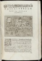
- Beinecke Rare Book and Manuscript Library > Descrittione dell'isola Spagnuola prima iso la scoperta dal Colombo
- Call Number:
- 1985 +31
- Collection Title:
- L'isole piu famose del mondo / descritte da Thomaso Porcacchi da Castiglione Arretino e intagliate
- Image Count:
- 1
- Resource Type:
- Maps, Atlases & Globes
- Found in:
- Beinecke Rare Book and Manuscript Library > Descrittione dell'isola Cuba, che dal Colombo fu scoperta insieme con la Spagnuloa
- Call Number:
- 1974 +188
- Collection Title:
- L'isole piv famose del mondo descritte da Thomaso Porcacchi da Castiglione Arretino e intagliate da
- Image Count:
- 1
- Resource Type:
- Maps, Atlases & Globes
- Found in:
- Beinecke Rare Book and Manuscript Library > Descrittione dell' isola Spagnuola
- Call Number:
- 1974 +188
- Collection Title:
- L'isole piv famose del mondo descritte da Thomaso Porcacchi da Castiglione Arretino e intagliate da
- Image Count:
- 1
- Resource Type:
- Maps, Atlases & Globes
- Found in:
- Beinecke Rare Book and Manuscript Library > Descrittione dell' isola Cuba
- Call Number:
- 1976 +310
- Collection Title:
- L'isole piv famose del mondo descritte da Thomaso Porcacchi da Castiglione Arretino e intagliate da
- Image Count:
- 1
- Resource Type:
- Maps, Atlases & Globes
- Found in:
- Beinecke Rare Book and Manuscript Library > Descrittione dell'isola Spagnuola
- Call Number:
- 1976 +310
- Collection Title:
- L'isole piv famose del mondo descritte da Thomaso Porcacchi da Castiglione Arretino e intagliate da
- Image Count:
- 1
- Resource Type:
- Maps, Atlases & Globes
- Found in:
- Beinecke Rare Book and Manuscript Library > Descrittione dell'isola Cuba
- Call Number:
- Gfp94 +Gi597
- Collection Title:
- Geografia; cioè, Descrittione vniversale della terra. Partita in due volumi, nel primo de' quali si
- Image Count:
- 1
- Resource Type:
- Maps, Atlases & Globes
- Found in:
- Beinecke Rare Book and Manuscript Library > [Geographia. Italian]
- Call Number:
- 1977 +379
- Collection Title:
- Geografia; cioè, Descrittione vniversale della terra. Partita in due volumi, nel primo de' quali si
- Image Count:
- 1
- Resource Type:
- Maps, Atlases & Globes
- Found in:
- Beinecke Rare Book and Manuscript Library > [Geographia. Italian]
- Call Number:
- 1975 +1
- Collection Title:
- L'isole piv famose del mondo descritte da Thomaso Porcacchi da Castiglione Arretino e intagliate da
- Image Count:
- 1
- Resource Type:
- Maps, Atlases & Globes
- Found in:
- Beinecke Rare Book and Manuscript Library > Descrittione dell'isola Spagnuola
- Call Number:
- 1975 +1
- Collection Title:
- L'isole piv famose del mondo descritte da Thomaso Porcacchi da Castiglione Arretino e intagliate da
- Image Count:
- 1
- Resource Type:
- Maps, Atlases & Globes
- Found in:
- Beinecke Rare Book and Manuscript Library > Descrittione dell' isola Cuba
- Call Number:
- 1977 +435
- Collection Title:
- Geografia; cioè, Descrittione vniversale della terra. Partita in due volumi, nel primo de' quali si
- Image Count:
- 1
- Resource Type:
- Maps, Atlases & Globes
- Found in:
- Beinecke Rare Book and Manuscript Library > [Geographia. Italian]
- Call Number:
- 1977 +435
- Collection Title:
- Geografia; cioè, Descrittione vniversale della terra. Partita in due volumi, nel primo de' quali si
- Image Count:
- 1
- Resource Type:
- Maps, Atlases & Globes
- Found in:
- Beinecke Rare Book and Manuscript Library > [Geographia. Italian]
- Call Number:
- 1977 1341
- Collection Title:
- Geographiae vniversae opvs habentur Cl. Ptolemaei ... Geographicae enarationis libri octo [tr. by W
- Image Count:
- 1
- Resource Type:
- Maps, Atlases & Globes
- Found in:
- Beinecke Rare Book and Manuscript Library > Vniversi orbis descriptio ad vsvm navigantivm
- Call Number:
- Gfp94 gf525j
- Collection Title:
- Geographiae vniversae ... opvs ... habentur Cl. Ptolemaei ... Geographicae enarrationis libri octo
- Image Count:
- 1
- Resource Type:
- Maps, Atlases & Globes
- Found in:
- Beinecke Rare Book and Manuscript Library > Vniversi orbis descriptop as vsvm navigantivm
- Call Number:
- 1977 +392
- Collection Title:
- A survey of the cities of London and Westminster : containing the original, antiquity, increase
- Image Count:
- 1
- Resource Type:
- Maps, Atlases & Globes
- Found in:
- Beinecke Rare Book and Manuscript Library > Portsoken ward being part of the parish of St. Buttolphs Aldgate, taken from the last survey, with corrections and additions
- Call Number:
- 1977 +392
- Collection Title:
- A survey of the cities of London and Westminster : containing the original, antiquity, increase
- Image Count:
- 1
- Resource Type:
- Maps, Atlases & Globes
- Found in:
- Beinecke Rare Book and Manuscript Library > The Custom House
- Call Number:
- 1977 +392
- Collection Title:
- A survey of the cities of London and Westminster : containing the original, antiquity, increase
- Image Count:
- 1
- Resource Type:
- Maps, Atlases & Globes
- Found in:
- Beinecke Rare Book and Manuscript Library > Aldgate Ward with its division into parishes. Taken from the last survey, with corrections & additions
- Call Number:
- 1977 +392
- Collection Title:
- A survey of the cities of London and Westminster : containing the original, antiquity, increase
- Image Count:
- 1
- Resource Type:
- Maps, Atlases & Globes
- Found in:
- Beinecke Rare Book and Manuscript Library > Part of Aldgate Ward
- Call Number:
- 1977 +392
- Collection Title:
- A survey of the cities of London and Westminster : containing the original, antiquity, increase
- Image Count:
- 1
- Resource Type:
- Maps, Atlases & Globes
- Found in:
- Beinecke Rare Book and Manuscript Library > Bishop Gate Street Ward taken from the last survey and corrected
- Call Number:
- 1977 +392
- Collection Title:
- A survey of the cities of London and Westminster : containing the original, antiquity, increase
- Image Count:
- 1
- Resource Type:
- Maps, Atlases & Globes
- Found in:
- Beinecke Rare Book and Manuscript Library > Cornhill Ward with its division into parishes, taken from the last survey &c
- Call Number:
- 1977 +392
- Collection Title:
- A survey of the cities of London and Westminster : containing the original, antiquity, increase
- Image Count:
- 1
- Found in:
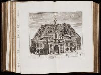
- Beinecke Rare Book and Manuscript Library > The Royal Exchange of London
- Call Number:
- 1977 +392
- Collection Title:
- A survey of the cities of London and Westminster : containing the original, antiquity, increase
- Image Count:
- 1
- Resource Type:
- Maps, Atlases & Globes
- Found in:
- Beinecke Rare Book and Manuscript Library > Candlewick Ward with its division into parishes. Corrected from the last survey
- Call Number:
- 1977 +392
- Collection Title:
- A survey of the cities of London and Westminster : containing the original, antiquity, increase
- Image Count:
- 1
- Resource Type:
- Maps, Atlases & Globes
- Found in:
- Beinecke Rare Book and Manuscript Library > Walbrook Ward and Dow Gate Ward with its division into parishes taken from the last surveys
- Call Number:
- 1977 +392
- Collection Title:
- A survey of the cities of London and Westminster : containing the original, antiquity, increase
- Image Count:
- 1
- Resource Type:
- Maps, Atlases & Globes
- Found in:
- Beinecke Rare Book and Manuscript Library > Queen Hith Ward and Vintry Ward with their division into parishes taken from the last surveys
- Call Number:
- 1977 +392
- Collection Title:
- A survey of the cities of London and Westminster : containing the original, antiquity, increase
- Image Count:
- 1
- Resource Type:
- Maps, Atlases & Globes
- Found in:
- Beinecke Rare Book and Manuscript Library > Bread Street Ward and Cordwainer Ward with it's division into parishes taken from the last survey
- Call Number:
- 1977 +392
- Collection Title:
- A survey of the cities of London and Westminster : containing the original, antiquity, increase
- Image Count:
- 1
- Resource Type:
- Maps, Atlases & Globes
- Found in:
- Beinecke Rare Book and Manuscript Library > Cheape Ward with its division into parishes, taken from the last survey, with corrections and additions
- Call Number:
- 1977 +392
- Collection Title:
- A survey of the cities of London and Westminster : containing the original, antiquity, increase
- Image Count:
- 1
- Found in:
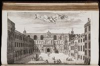
- Beinecke Rare Book and Manuscript Library > The Prospect of Guild Hall
- Call Number:
- 1977 +392
- Collection Title:
- A survey of the cities of London and Westminster : containing the original, antiquity, increase
- Image Count:
- 1
- Resource Type:
- Maps, Atlases & Globes
- Found in:
- Beinecke Rare Book and Manuscript Library > Coleman Street Ward and Bashishaw Ward taken from the last survey, with corrections and additions
- Call Number:
- 1977 +392
- Collection Title:
- A survey of the cities of London and Westminster : containing the original, antiquity, increase
- Image Count:
- 1
- Resource Type:
- Maps, Atlases & Globes
- Found in:
- Beinecke Rare Book and Manuscript Library > The Wards of Farington within and Baynards Castle with its divisions into parishes taken from the last survey with corrections
- Call Number:
- 1977 +392
- Collection Title:
- A survey of the cities of London and Westminster : containing the original, antiquity, increase
- Image Count:
- 1
- Resource Type:
- Maps, Atlases & Globes
- Found in:
- Beinecke Rare Book and Manuscript Library > Farington Ward without, with its divisions into parishes, taken from the last survey with corrections & amendments
- Call Number:
- 1977 +392
- Collection Title:
- A survey of the cities of London and Westminster : containing the original, antiquity, increase
- Image Count:
- 1
- Resource Type:
- Maps, Atlases & Globes
- Found in:
- Beinecke Rare Book and Manuscript Library > St. Olave and St. Mary Magdalen Bermondsey Southwark, taken from the last survey with corrections
- Call Number:
- 1977 +392
- Collection Title:
- A survey of the cities of London and Westminster : containing the original, antiquity, increase
- Image Count:
- 1
- Resource Type:
- Maps, Atlases & Globes
- Found in:
- Beinecke Rare Book and Manuscript Library > A mapp of the parishes of St. Saviours Southwark and St. Georges taken from the last survey with corrections
- Call Number:
- 1977 +392
- Collection Title:
- A survey of the cities of London and Westminster : containing the original, antiquity, increase
- Image Count:
- 1
- Resource Type:
- Maps, Atlases & Globes
- Found in:
- Beinecke Rare Book and Manuscript Library > A map of the parish if St. Katherines by the Tower
- Call Number:
- 1977 +392
- Collection Title:
- A survey of the cities of London and Westminster : containing the original, antiquity, increase
- Image Count:
- 1
- Resource Type:
- Maps, Atlases & Globes
- Found in:
- Beinecke Rare Book and Manuscript Library > The parish of St. Johns Wapping
- Call Number:
- 1977 +392
- Collection Title:
- A survey of the cities of London and Westminster : containing the original, antiquity, increase
- Image Count:
- 1
- Resource Type:
- Maps, Atlases & Globes
- Found in:
- Beinecke Rare Book and Manuscript Library > A map of the parish of St. Dustans Stepney and Stebunheath divided into hamlets
- Call Number:
- 1977 +392
- Collection Title:
- A survey of the cities of London and Westminster : containing the original, antiquity, increase
- Image Count:
- 1
- Resource Type:
- Maps, Atlases & Globes
- Found in:
- Beinecke Rare Book and Manuscript Library > Spittle Fields and places adjacent taken from the last survey with corrections
- Call Number:
- 1977 +392
- Collection Title:
- A survey of the cities of London and Westminster : containing the original, antiquity, increase
- Image Count:
- 1
- Resource Type:
- Maps, Atlases & Globes
- Found in:
- Beinecke Rare Book and Manuscript Library > Shoreditch, Norton Folgate, and Crepple Gate without, taken from the last survey with corrections
- Call Number:
- 1977 +392
- Collection Title:
- A survey of the cities of London and Westminster : containing the original, antiquity, increase
- Image Count:
- 1
- Resource Type:
- Maps, Atlases & Globes
- Found in:
- Beinecke Rare Book and Manuscript Library > Cow Cross being St. Sepulcher's parish without and the Charter House taken from the last survey with corrections
- Call Number:
- 1977 +392
- Collection Title:
- A survey of the cities of London and Westminster : containing the original, antiquity, increase
- Image Count:
- 1
- Resource Type:
- Maps, Atlases & Globes
- Found in:
- Beinecke Rare Book and Manuscript Library > A mapp of the parishes of St. Clements Danes, St. Mary Savoy; with the Rolls Liberty and Lincolns Inn, taken from the last survey with corrections and additions
- Call Number:
- 1993 +44
- Collection Title:
- Topographia provinciarum austriacaru, Austriæ, Striæ, Carinthiæ, Carniolæ, Tyrolis. etc.: das ist
- Image Count:
- 1
- Found in:
- Beinecke Rare Book and Manuscript Library > [Topographia provinciarum Austriacarum]
- Call Number:
- 1977 +392
- Collection Title:
- A survey of the cities of London and Westminster : containing the original, antiquity, increase
- Image Count:
- 1
- Found in:
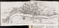
- Beinecke Rare Book and Manuscript Library > The city of London as in Q Elisabeth's time
- Creator:
- Seller, John, fl. 1658-1698
- Call Number:
- 1976 Folio 139
- Collection Title:
- The English pilot: describing the sea-coasts, capes, head-lands, soundings, sands, shoals, rocks
- Image Count:
- 1
- Found in:
- Beinecke Rare Book and Manuscript Library > A large description of the two chanells in the River Dwina goeing up to the citty of Archangel by John Seller
- Creator:
- Chantry, John
- Call Number:
- Ee +633gb
- Collection Title:
- The voyages and travells of the ambassadors sent by Frederick, duke of Holstein, to the great Duke
- Image Count:
- 1
- Resource Type:
- Maps, Atlases & Globes
- Found in:
- Beinecke Rare Book and Manuscript Library > The course of the great River Wolga
- Creator:
- Sanson, Nicolas, 1600-1667
- Call Number:
- 1973 Folio 17
- Collection Title:
- Atlas francois, contenant les cartes geographiques dans les quelles sont tres exactement remarquez
- Image Count:
- 1
- Resource Type:
- Maps, Atlases & Globes
- Found in:
- Beinecke Rare Book and Manuscript Library > La Generalite de Paris divisee ens ses eslections
- Call Number:
- 1977 Folio 78
- Collection Title:
- A New and accurate chart of the West-India Islands and coast, with the gulf passage through the New
- Image Count:
- 1
- Resource Type:
- Maps, Atlases & Globes
- Found in:
- Beinecke Rare Book and Manuscript Library > A plan of the road of Port Paix in the island of Hispaniola, pl. 35.
- Call Number:
- 1977 Folio 78
- Collection Title:
- A New and accurate chart of the West-India Islands and coast, with the gulf passage through the New
- Image Count:
- 1
- Resource Type:
- Maps, Atlases & Globes
- Found in:
- Beinecke Rare Book and Manuscript Library > A plan of Monte-Christe Bay with the Seven Brothers on the north coast of St. Domingo, pl. 38
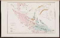
- Creator:
- Grange. J
- Call Number:
- 1998 995
- Collection Title:
- Voyage au pole sud et dans l'Oceanie sur les corvettes l'Astrolabe et la Zelee : execute par ordre
- Image Count:
- 1
- Found in:
- Beinecke Rare Book and Manuscript Library > Carte geologique de la Patagonie et de la terre de feu
- Call Number:
- 1977 +246
- Collection Title:
- Geografia; cioè, Descrittione vniversale della terra. Partita in due volumi, nel primo de' quali si
- Image Count:
- 1
- Resource Type:
- Books, Journals & Pamphlets
- Found in:
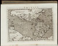
- Beinecke Rare Book and Manuscript Library > Descrittione dell-America, o dell'India Occidentale. America
- Call Number:
- Gfp94 +Gi597
- Collection Title:
- Geografia; cioe, Descrittione vniversale della terra. Partita in due volumi, nel primo de' quali si
- Image Count:
- 1
- Resource Type:
- Books, Journals & Pamphlets
- Found in:
- Beinecke Rare Book and Manuscript Library > [Geographia. Italian]
- Call Number:
- 1977 +379
- Collection Title:
- Geografia; cioe, Descrittione vniversale della terra. Partita in due volumi, nel primo de' quali si
- Image Count:
- 1
- Resource Type:
- Books, Journals & Pamphlets
- Found in:
- Beinecke Rare Book and Manuscript Library > [Geographia. Italian]
- Call Number:
- 1977 1341
- Collection Title:
- Geographiae vniversae opvs habentur Cl. Ptolemaei ... Geographicae enarationis libri octo [tr. by W
- Image Count:
- 1
- Resource Type:
- Books, Journals & Pamphlets
- Found in:
- Beinecke Rare Book and Manuscript Library > America
- Call Number:
- Gfp94 gf525j
- Collection Title:
- Geographiae vniversae ... opvs ... habentur Cl. Ptolemaei ... Geographicae enarrationis libri octo
- Image Count:
- 1
- Resource Type:
- Books, Journals & Pamphlets
- Found in:
- Beinecke Rare Book and Manuscript Library > America
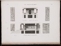
- Call Number:
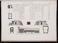
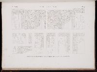
- 1971 Folio 601
- Collection Title:
- Description de lEgypte, ou, Recueil de observations et des recherches qui ont ete faites en Egypte
- Image Count:
- 1
- Found in:
- Beinecke Rare Book and Manuscript Library > Alexandrie. pl. 41
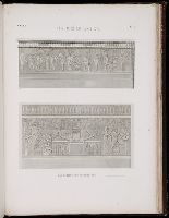
- Call Number:
- 1971 Folio 601
- Collection Title:
- Description de lEgypte, ou, Recueil de observations et des recherches qui ont ete faites en Egypte
- Image Count:
- 1
- Found in:
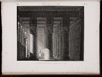
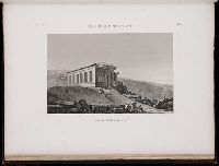
- Beinecke Rare Book and Manuscript Library > Denderah. (Tentyris). pl. 18
- Call Number:
- 1971 Folio 601
- Collection Title:
- Description de lEgypte, ou, Recueil de observations et des recherches qui ont ete faites en Egypte
- Image Count:
- 1
- Found in:
- Beinecke Rare Book and Manuscript Library > Denderah. (Tentyris). pl. 30
- Call Number:
- 1971 Folio 601
- Collection Title:
- Description de lEgypte, ou, Recueil de observations et des recherches qui ont ete faites en Egypte
- Image Count:
- 1
- Found in:
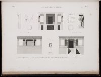
- Beinecke Rare Book and Manuscript Library > Syout. (Lycopolis). pl. 48
- Call Number:
- 1971 Folio 601
- Collection Title:
- Description de lEgypte, ou, Recueil de observations et des recherches qui ont ete faites en Egypte
- Image Count:
- 1
- Found in:
- Beinecke Rare Book and Manuscript Library > Syout. (Lycopolis). pl. 49
- Call Number:
- 1971 Folio 601
- Collection Title:
- Description de lEgypte, ou, Recueil de observations et des recherches qui ont ete faites en Egypte
- Image Count:
- 1
- Found in:
- Beinecke Rare Book and Manuscript Library > Ile d'Elephantine. pl. 34
- Call Number:
- 1971 Folio 601
- Collection Title:
- Description de lEgypte, ou, Recueil de observations et des recherches qui ont ete faites en Egypte
- Image Count:
- 1
- Found in:
- Beinecke Rare Book and Manuscript Library > Ile d'Elephantine. pl. 35
- Call Number:
- 1971 Folio 601
- Collection Title:
- Description de lEgypte, ou, Recueil de observations et des recherches qui ont ete faites en Egypte
- Image Count:
- 1
- Found in:
- Beinecke Rare Book and Manuscript Library > Ile d'Elephantine. pl. 36
- Call Number:
- 1971 Folio 601
- Collection Title:
- Description de lEgypte, ou, Recueil de observations et des recherches qui ont ete faites en Egypte
- Image Count:
- 1
- Found in:
- Beinecke Rare Book and Manuscript Library > Ile d'Elephantine. pl. 37
- Call Number:
- 1971 Folio 601
- Collection Title:
- Description de lEgypte, ou, Recueil de observations et des recherches qui ont ete faites en Egypte
- Image Count:
- 1
- Found in:
- Beinecke Rare Book and Manuscript Library > Ile d'Elephantine et Syene. pl. 38
- Creator:
- Jefferys, Thomas, d. 1771
- Call Number:
- 1977 Folio 96
- Collection Title:
- The West-India atlas: or, A compendious description of the West-Indies: illustrated with forty
- Image Count:
- 1
- Resource Type:
- Maps, Atlases & Globes
- Found in:
- Beinecke Rare Book and Manuscript Library > South part of St. Domingo, of Hispaniola, by Thos Jeffreys geographer to his Majesty
- Creator:
- Jefferys, Thomas, d. 1771
- Call Number:
- 1977 Folio 96
- Collection Title:
- The West-India atlas: or, A compendious description of the West-Indies: illustrated with forty
- Image Count:
- 1
- Resource Type:
- Maps, Atlases & Globes
- Found in:
- Beinecke Rare Book and Manuscript Library > Jamaica from the latest surveys; improved and engraved by Thomas Jefferys geographer to the king
- Creator:
- Keulen, Gerard van
Keulen, Johannes van.
Marre, Jan de, 1696-1763.
Vooght, Claes Janszoon, d. 1696.
- Call Number:
- 1973 Folio 103
- Collection Title:
- De Nieuwe groote lichtende zee-fakkel ...
- Image Count:
- 1
- Resource Type:
- Maps, Atlases & Globes
- Found in:
- Beinecke Rare Book and Manuscript Library > Des rivier legt op de Hoogte von 18 Graaden Zuyder Breedte aan het Land van de Megosie ter Kuste van Quama / Noord kust van't eyland ...
- Creator:
- Keulen, Gerard van
Keulen, Johannes van.
Marre, Jan de, 1696-1763.
Vooght, Claes Janszoon, d. 1696.
- Call Number:
- 1973 Folio 103
- Collection Title:
- De Nieuwe groote lichtende zee-fakkel ...
- Image Count:
- 1
- Resource Type:
- Maps, Atlases & Globes
- Found in:
- Beinecke Rare Book and Manuscript Library > De Oostin-dische zee / Het Eyland Mayota
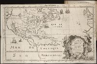
- Creator:
- Buache, Philippe, 1700-1773
Fuentes, Bartolome de, 17th cent
- Call Number:
- ZZc70 752L
- Collection Title:
- Explication de la carte des nouvelles decouvertes au nord de la mer du Sud; par m. de Lisle ...
- Image Count:
- 1
- Resource Type:
- Maps, Atlases & Globes
- Found in:
- Beinecke Rare Book and Manuscript Library > Carte de nouvelles decouvertes au nord de la mer du Sud, tant a lest de la Siberie et du Kamtchatka, qua louest de la Nouvelle France
- Creator:
- Keulen, Gerard van
Keulen, Johannes van.
Marre, Jan de, 1696-1763.
Vooght, Claes Janszoon, d. 1696.
- Call Number:
- 1973 Folio 103
- Collection Title:
- De Nieuwe groote lichtende zee-fakkel ...
- Image Count:
- 1
- Resource Type:
- Maps, Atlases & Globes
- Found in:
- Beinecke Rare Book and Manuscript Library > Madagascar
- Call Number:
- 1977 +379
- Collection Title:
- Geografia; cioe, Descrittione vniversale della terra. Partita in due volumi, nel primo de' quali si
- Image Count:
- 1
- Found in:
- Beinecke Rare Book and Manuscript Library > A new map of that part of Africacalled the coast of Guinea ...
- Published / Created:
- undated
- Call Number:
- Folio Q115 H84 1B
- Collection Title:
- Atlas geographique et physique des regions equinoxiales du nouveau continent, fonde sur des
- Image Count:
- 1
- Resource Type:
- Maps, Atlases & Globes
- Found in:
- Beinecke Rare Book and Manuscript Library > Carte du Rio Grande de la Magdalena depuis le 4 [degrees] Latitude jusqu'a son embouchure. No. 24
- Call Number:
- 1989 +19
- Collection Title:
- A collection of voyages and travels, some now first printed from original manuscripts, others now
- Image Count:
- 1
- Resource Type:
- Maps, Atlases & Globes
- Found in:
- Beinecke Rare Book and Manuscript Library > A chart and map of the Gold Coast of Guinea from Rio da Corsa to Ro da Volta. vol. V [5], pl. K
- Call Number:
- WeInd Ehc 762J
- Collection Title:
- A description of the Spanish islands and settlements on the coast of the West Indies / compiled
- Image Count:
- 1
- Resource Type:
- Maps, Atlases & Globes
- Found in:
- Beinecke Rare Book and Manuscript Library > The island of Hispaniola called by the French St. Domingo. Subject to France and Spain
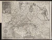
- Creator:
- Hole, William, d. 1624, engraver
Smith, John, 1580-1631.
- Call Number:
- Taylor 256
- Collection Title:
- A map of Virginia : vvith a description of the covntrey, the commodities, people, government and
- Image Count:
- 1
- Found in:
- Beinecke Rare Book and Manuscript Library > Virginia discouered and described by Captayn John Smith
- Creator:
- Bouttats, Gaspard, b. ca. 1640, engraver
- Call Number:
- Pequot H41
- Collection Title:
- Aenmerckelycke historische reys-beschryvinge door verscheyde landen veel grooter als die van geheel
- Image Count:
- 1
- Found in:
- Beinecke Rare Book and Manuscript Library > Carte d'un nouueau monde, entre le nouueau Mexique et la mer glacialle
- Creator:
- Evans, Lewis, 1700?-1756
- Call Number:
- Egg +755E
- Collection Title:
- Geographical, historical, political, philosophical and mechanical essays : the first, containing an
- Image Count:
- 1
- Found in:
- Beinecke Rare Book and Manuscript Library > A general map of the middle British colonies in America
- Call Number:
- 1978 +73
- Collection Title:
- The ecclesiastical history of New-England from its first planting in the year 1620 unto the year of
- Image Count:
- 1
- Resource Type:
- Books, Journals & Pamphlets
- Found in:
- Beinecke Rare Book and Manuscript Library > An exact mapp of New England and New York
- Call Number:
- 1993 72
- Collection Title:
- Histoire des avanturiers qui sont signalez dans les Indes : contenant ce quils ont fait de plus
- Image Count:
- 1
- Found in:
- Beinecke Rare Book and Manuscript Library > Carte du continentde L'Ameriqueet de Isles principa ...