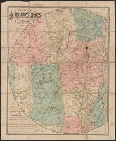
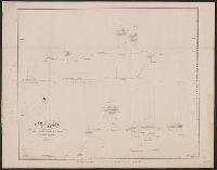
"Copyrighted 1892 by S.R. Stoddard, Glens Falls, N.Y.", Neat line on the north, west, and south is a circle whose diameter is ca. 120 mi. on the 74th meridian W of Greenwich (also nominally 3⁰ E of Washington), center just west of Mount Marcy., and Prime meridi
Autograph: Fred. H. Comstock., Prime meridians: Greenwich and Washington. Latitude not indicated., Relief shown by hachures and spot heights., and Right side cropped at 63 cm from leftmost point from center.
Publisher:
S.R. Stoddard],
Subject (Geographic):
Adirondack Mountains (N.Y.)--Maps. and Adirondack Park (N.Y.)--Maps.
Subject (Name):
Comstock, Fred H.--Autograph. and Neuman & Dinglinger
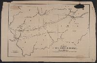
"Copyrighted 1881 by S.R. Stoddard, Glens Falls, N.Y." and Neat line on the north, west, and south is a circle whose diameter is approximately 120 miles on the 74th meridian W of Greenwich (also nominally 3° E of Washington), center just west of Mount Marcy.
Publisher:
S.R. Stoddard,
Subject (Geographic):
Adirondack Mountains (N.Y.)--Administrative and political divisions--Maps., Adirondack Mountains (N.Y.)--Distances, etc.--Maps., Adirondack Mountains (N.Y.)--Maps., and New York (State)--Adirondack Mountains
Subject (Name):
Morgan, R. J.--Autograph. and Neuman & Dinglinger
Subject (Topic):
Administrative and political divisionsDistancesRailroadsRailroads--New York (State)--Adirondack Mountains--Maps.
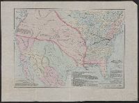
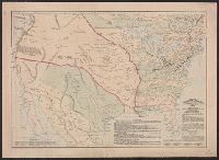
"July, 1919.", Highway goes through the states of Colorado, Kansas, Oklahoma and Arkansas., and Includes information about Colorado Springs and Hot Springs National Park in Hot Springs, Arkansas.
Publisher:
National Highways Association,
Subject (Name):
Albert Pike Highway Association, Albert Pike Highway--Road maps, and National Highways Association
Map of the Alton and Springfield railroad, in Illinois
Description:
Imperfect: mutilated; hole burned through upper right corner of map with no apparent loss of text., Map also shows Indiana, Ohio and part of Michigan., and Shows railroads built, chartered and contemplated.
"Entered according to Act of Congress in the year 1875 by Asher & Adams in the Office of the Librarian of Congress at Washington.", Includes map explanations, timeline, and, Relief shown pictorially., and Sheet measures 46.6 x 66.7 cm. Cross Collection no. 155.
Publisher:
Asher and Adams,
Subject (Geographic):
Mexico--Historical geography--Maps and United States--Historical geography--Maps
Subject (Name):
American Geographical Society of New York
Subject (Topic):
Colonies--America--Maps and Railroads--East (U.S.)--Maps
"Entered according to Act of Congress in the year 1875 by Asher & Adams in the Office of the Librarian of Congress at Washington.", Includes map explanations, timeline, and description of routes., and Relief shown pictorially.
Publisher:
Asher and Adams,
Subject (Geographic):
Mexico--Historical geography--Maps and United States--Historical geography--Maps
Subject (Name):
American Geographical Society of New York
Subject (Topic):
Colonies--America--Maps and Railroads--East (U.S.)--Maps
"Entered according to Act of Congress in the year 1875 by Asher & Adams in the Office of the Librarian of Congress at Washington.", Includes map explanations, timeline, and description of routes., Mounted on linen. Sheet measures 46.2 x 63.7 cm., and Relief show
Publisher:
Asher and Adams,
Subject (Geographic):
Mexico--Historical geography--Maps and United States--Historical geography--Maps
Subject (Name):
American Geographical Society of New York
Subject (Topic):
Colonies--America--Maps and Railroads--East (U.S.)--Maps