Search
You Searched For
Search Results
- Published / Created:
- 1814
- Call Number:
- 764 B65 1814
- Container / Volume:
- BRBL_00455
- Image Count:
- 1
- Resource Type:
- Maps, Atlases & Globes
- Found in:
- Beinecke Rare Book and Manuscript Library > Map of Boston in the State of Massachusetts. Surveyed by J.G. Hales Geogr. & surveyor. I.R. Penniman Del. Engraved by T. Wightman Jr.
- Published / Created:
- [1820?]
- Call Number:
- 76 1820
- Container / Volume:
- BRBL_00443
- Image Count:
- 1
- Resource Type:
- Maps, Atlases & Globes
- Found in:
- Beinecke Rare Book and Manuscript Library > Map of the States of Maine, New Hampshire, Vermont, Massachusetts, Connecticut & Rhode Island by H. S. Tanner ... 14th day of Novr. 1820
- Published / Created:
- 1825
- Call Number:
- 76 1825
- Container / Volume:
- BRBL_00444
- Image Count:
- 1
- Resource Type:
- Maps, Atlases & Globes
- Found in:
- Beinecke Rare Book and Manuscript Library > Map of the States of Maine, New Hampshire, Vermont, Massachusetts, Connecticut & Rhode Island by H. S. Tanner c.1820, improved to 1825.
- Published / Created:
- [1831?]
- Call Number:
- 764 B63 1831
- Container / Volume:
- BRBL_00454
- Image Count:
- 1
- Resource Type:
- Maps, Atlases & Globes
- Found in:
- Beinecke Rare Book and Manuscript Library > A Map of the Town of Bolton in the County of Worcester and the Commonwealth of Massachusetts. Surveyed by Silas Holman in the Year 1831.
- Published / Created:
- [1839]
- Call Number:
- 76 1839
- Container / Volume:
- BRBL_00444
- Image Count:
- 4
- Resource Type:
- Maps, Atlases & Globes
- Found in:
- Beinecke Rare Book and Manuscript Library > Map of Maine, New Hampshire, Vermont, Massachusetts, Rhode Island and Connecticut. Exhibiting the Post Offices, Post Roads, Canals, Rail Roads, &c. by David H. Burr ...
- Creator:
- Society for the Diffusion of Useful Knowledge (Great Britain)
- Published / Created:
- 1832
- Call Number:
- 755 1832A
- Container / Volume:
- BRBL_00440
- Image Count:
- 1
- Resource Type:
- Maps, Atlases & Globes
- Found in:
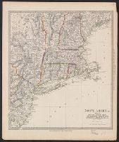
- Beinecke Rare Book and Manuscript Library > North America. Sheet VI, New-York, Vermont, Maine, New-Hampshire, Massachusetts, Connecticut, Rhode-Island, and New-Jersey / published by the Society for the Diffusion of Useful Knowledge.
- Published / Created:
- 1849
- Call Number:
- 76BF 1849T
- Container / Volume:
- BRBL_00446
- Image Count:
- 1
- Resource Type:
- Maps, Atlases & Globes
- Found in:
- Beinecke Rare Book and Manuscript Library > Sketch A, showing the process in section no. 1, U.S. Coast Survey in 1844, '45, '46, '47, '48, & '49. [Coast of Rhode Island, Massachusetts, New Hampshire, and Maine]
- Published / Created:
- 1775]
- Call Number:
- 76 1740
- Container / Volume:
- BRBL_00690
- Image Count:
- 1
- Resource Type:
- Maps, Atlases & Globes
- Subject (Geographic):
- Massachusetts--Maps--Early works to
- Found in:
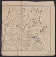
- Beinecke Rare Book and Manuscript Library > A map of 100 miles round Boston [cartographic material].
- Published / Created:
- [1801]
- Call Number:
- 761 1801
- Container / Volume:
- BRBL_00447
- Image Count:
- 2
- Resource Type:
- Maps, Atlases & Globes
- Found in:
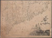
- Beinecke Rare Book and Manuscript Library > Map of the district of Maine, Massachusetts, compiled from actual surveys made by order of the General Court, and under the inspection of agents of their appointment, by Osgood Carleton.