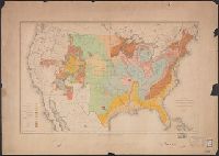
"Jan. 1, 1915" in lower left margin., Irrigated areas shown on outline map of the United States. Explanation in margin., and This edition has county names printed in blue.
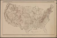
Each sheet is colored to show rocks from one or two geologic eras only., In upper border: U.S. Geological Survey. Fourteenth annual report, pl. II., Includes legend., Relief shown by contour lines., and Shows Indian reservations.
Publisher:
U.S. Geological Survey,
Subject (Name):
Bien, Julius, 1826-1909 and Geological Survey (U.S.)
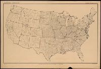
Ms. notes in red and blue highlighting 500' and 1500' contours. Imperfect: Mutilated. Upper left corner missing, text wanting. and Relief shown by contours.