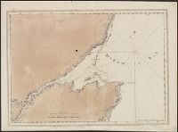
1. [A chart of the bay and river of Miramichy / surveyed by Samuel Holland]. Creator: Des Barres, Joseph F. W. (Joseph Frederick Wallet), 1722-1824 Published / Created: Septr. 1 1781. Call Number: 733cea M67 1781 Container / Volume: BRBL_00379 Image Count: 1 Resource Type: Maps, Atlases & Globes Description: From the author's Atlantic Neptune. Found in: Beinecke Rare Book and Manuscript Library > [A chart of the bay and river of Miramichy / surveyed by Samuel Holland].
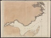
2. [A chart of Chaleurs Bay / surveyed by Samuel Holland]. Creator: Des Barres, Joseph F. W. (Joseph Frederick Wallet), 1722-1824 Published / Created: Aug. 1 1781. Call Number: 734cea C35 1781 Container / Volume: BRBL_00380 Image Count: 1 Resource Type: Maps, Atlases & Globes Description: From the author's Atlantic Neptune. Found in: Beinecke Rare Book and Manuscript Library > [A chart of Chaleurs Bay / surveyed by Samuel Holland].
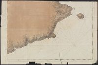
3. [A chart of the Bay of Gaspey &c. / surveyed by Samuel Holland]. Creator: Des Barres, Joseph F. W. (Joseph Frederick Wallet), 1722-1824 Published / Created: Aug. 1 1781. Call Number: 734cea G214 1781 Container / Volume: BRBL_00380 Image Count: 2 Resource Type: Maps, Atlases & Globes Description: From the author's Atlantic Neptune. Found in: Beinecke Rare Book and Manuscript Library > [A chart of the Bay of Gaspey &c. / surveyed by Samuel Holland].