Skip to search
Skip to main content
Skip to first result
Search
You Searched For
Access
Public
Format
cartographic
New Search
Search Results
Creator:
Published / Created:
1943
Call Number:
533gm 1943
Container / Volume:
BRBL_00288
Image Count:
1
Resource Type:
Maps, Atlases & Globes
Found in:
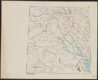
Beinecke Rare Book and Manuscript Library > ʻIrāq [cartographic material] : special strategic map.
Call Number:
783 1673D
Container / Volume:
BRBL_00507
Image Count:
1
Resource Type:
Maps, Atlases & Globes
Found in:
Beinecke Rare Book and Manuscript Library > virginia and Maryland. As it is planted and inhabited this present year 1670. Surveyed and Exactly Drawne by ... Augustin Herrman, 1673.
Call Number:
771 OS9 1836
Container / Volume:
BRBL_00490
Image Count:
1
Resource Type:
Maps, Atlases & Globes
Found in:
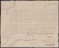
Beinecke Rare Book and Manuscript Library > map of the Village of Oswego Falls to be Sold on hte Premises by Jas. Bleecker & Sons on the 18th October 1836.
Published / Created:
[1700?]
Call Number:
36 R34 1700
Container / Volume:
BRBL_00126
Image Count:
1
Resource Type:
Maps, Atlases & Globes
Found in:
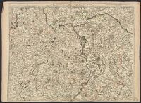
Beinecke Rare Book and Manuscript Library > m Palatinat et Electorat du Rhin, Archevesché Electorat de Mayence ... Basse Alsace cours du Rhin ... Par Crepy.
Published / Created:
1823
Call Number:
89 1823
Container / Volume:
BRBL_00657
Image Count:
1
Resource Type:
Maps, Atlases & Globes
Found in:
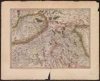
Beinecke Rare Book and Manuscript Library > geographisch-statistische charte von Guatemala.
Creator:
Published / Created:
1595?]
Call Number:
37 1595A
Image Count:
2
Resource Type:
Maps, Atlases & Globes
Found in:
Beinecke Rare Book and Manuscript Library > [Zurichgow et Basiliensis provincia].
Published / Created:
[1805?]
Call Number:
3841 1805
Container / Volume:
BRBL_00179
Image Count:
1
Resource Type:
Maps, Atlases & Globes
Found in:
Beinecke Rare Book and Manuscript Library > [Yonne, Nievre, Cote D'or] Gravé P.F. Tardieu. Ecrit par Dubuisson.
Published / Created:
191-?]
Call Number:
11hcf 1919D-18
Container / Volume:
BRBL_00010W
Image Count:
2
Resource Type:
Maps, Atlases & Globes
Found in:
Beinecke Rare Book and Manuscript Library > [XII. A Népesség Hitfelekezet Szerint.]
Creator:
Published / Created:
Anno Domini 1511]
Call Number:
11 1511A
Container / Volume:
BRBL_00732
Image Count:
1
Resource Type:
Maps, Atlases & Globes
Found in:
Beinecke Rare Book and Manuscript Library > [World map].
Creator:
Published / Created:
1511]
Call Number:
11 1511
Container / Volume:
BRBL_00732
Image Count:
2
Resource Type:
Maps, Atlases & Globes
Found in:
Beinecke Rare Book and Manuscript Library > [World map].
Published / Created:
March 1880.
Call Number:
11 1584
Container / Volume:
BRBL_00722
Image Count:
2
Resource Type:
Maps, Atlases & Globes
Found in:
Beinecke Rare Book and Manuscript Library > [World map].
Published / Created:
March 1880.
Call Number:
11 1600
Container / Volume:
BRBL_00002
Image Count:
1
Resource Type:
Maps, Atlases & Globes
Found in:
Beinecke Rare Book and Manuscript Library > [World map].
Published / Created:
March 1880.
Call Number:
11 1600
Image Count:
1
Resource Type:
Maps, Atlases & Globes
Found in:
Beinecke Rare Book and Manuscript Library > [World map].
Published / Created:
[Ca. 1612]
Call Number:
Taylor 258
Collection Title:
Descriptio ac delineatio geographica detectionis freti, sive, transitus ad occasum supra terras
Image Count:
1
Found in:
Beinecke Rare Book and Manuscript Library > [World map]
Published / Created:
[Ca. 1612]
Call Number:
Pequot G325
Collection Title:
Descriptio ac delineatio geographica detectionis freti, sive, transitus ad occasum supra terras
Image Count:
1
Found in:
Beinecke Rare Book and Manuscript Library > [World map]
Published / Created:
1606
Call Number:
Taylor 237
Collection Title:
Regimiento de navegacion mando hazer el rei nvestro senor por orden de sv conseio real de las
Image Count:
1
Found in:
Beinecke Rare Book and Manuscript Library > [World map]
Creator:
Published / Created:
1900?]
Call Number:
11 1529
Image Count:
2
Resource Type:
Maps, Atlases & Globes
Found in:
Beinecke Rare Book and Manuscript Library > [World map]
Published / Created:
1860?]
Call Number:
11 1860A
Container / Volume:
BRBL_00009
Image Count:
1
Resource Type:
Maps, Atlases & Globes
Found in:
Beinecke Rare Book and Manuscript Library > [World map in Chinese, 1860.]
Published / Created:
[1853]
Call Number:
11 1853
Container / Volume:
BRBL_00009
Image Count:
1
Resource Type:
Maps, Atlases & Globes
Found in:
Beinecke Rare Book and Manuscript Library > [World Map].
Published / Created:
[1848]
Call Number:
11 1848
Container / Volume:
BRBL_00009
Image Count:
1
Resource Type:
Maps, Atlases & Globes
Found in:
Beinecke Rare Book and Manuscript Library > [World Map].
Published / Created:
[1700]
Call Number:
11 1700A
Container / Volume:
BRBL_00004
Image Count:
1
Resource Type:
Maps, Atlases & Globes
Found in:
Beinecke Rare Book and Manuscript Library > [World Map] Portugal - The Country that has contributed most to geographic knowledge of the Globe in the course of one century she discovered and explored nearly two-thirds of the inhabited Globe.
Published / Created:
1845
Call Number:
54635cea 1845
Container / Volume:
BRBL_00290
Image Count:
2
Resource Type:
Maps, Atlases & Globes
Found in:
Beinecke Rare Book and Manuscript Library > [Whaling] Chart of Kamscatka, and the Sea of Ochotsk. Copied from the best Russian Authorities. ... respectfully dedicated to the Whaling Fleet of the United States.
Published / Created:
1855
Call Number:
811ca 1855
Container / Volume:
BRBL_00554
Image Count:
1
Resource Type:
Maps, Atlases & Globes
Found in:
Beinecke Rare Book and Manuscript Library > [Western part of upper peninsula, Michigan].
Published / Created:
[1945?]
Call Number:
307cbf 1945
Container / Volume:
BRBL_00036
Image Count:
1
Resource Type:
Maps, Atlases & Globes
Found in:
Beinecke Rare Book and Manuscript Library > [Western Europe].
Published / Created:
[1605]
Call Number:
3361 1605
Container / Volume:
BRBL_00088
Image Count:
2
Resource Type:
Maps, Atlases & Globes
Found in:
Beinecke Rare Book and Manuscript Library > [West Flanders] Petrus Koerius coelavit.
Published / Created:
[1940?]
Call Number:
38gmp B833 1940
Container / Volume:
BRBL_00171
Image Count:
1
Resource Type:
Maps, Atlases & Globes
Found in:
Beinecke Rare Book and Manuscript Library > [View taken above Bruges].
Published / Created:
1916?]
Call Number:
38am V58 1916
Container / Volume:
BRBL_00168
Image Count:
1
Resource Type:
Maps, Atlases & Globes
Found in:
Beinecke Rare Book and Manuscript Library > [Verdun and Environs].
Published / Created:
1916?].
Call Number:
38 V58 1916
Container / Volume:
BRBL_00166
Image Count:
1
Resource Type:
Maps, Atlases & Globes
Found in:
Beinecke Rare Book and Manuscript Library > [Verdun and Environs].
Creator:
Published / Created:
[1739?]
Call Number:
1973 folio 44
Collection Title:
Plan de Paris commence l’annee 1734. Dessine et grave sous les ordres de Messire Michel Etienne
Image Count:
1
Resource Type:
Maps, Atlases & Globes
Found in:
Beinecke Rare Book and Manuscript Library > [Untitled sectional plan of Paris]
Creator:
Published / Created:
[1739?]
Call Number:
1973 folio 44
Collection Title:
Plan de Paris commence l’annee 1734. Dessine et gravesous les ordres de Messire Michel Etienne
Image Count:
1
Resource Type:
Maps, Atlases & Globes
Found in:
Beinecke Rare Book and Manuscript Library > [Untitled sectional plan of Paris]
Published / Created:
[1808]
Call Number:
In W890 Zz808
Collection Title:
The history of the rise, progress, and accomplishment of the abolition of the African slave-trade
Image Count:
1
Resource Type:
Maps, Atlases & Globes
Found in:
Beinecke Rare Book and Manuscript Library > [Untitled map of abolition of the slave trade]
Call Number:
Taylor 58
Collection Title:
Praeclara Ferdinadi. Cortesii de noua maris Oceani Hyspania narratio ... Carolo Romanoru imperatori
Image Count:
1
Found in:
Beinecke Rare Book and Manuscript Library > [Untitled map of Tenochtitlan]
Published / Created:
1774
Call Number:
Pequot Sm95
Collection Title:
An examination of the Connecticut claim to lands in Pennsylvania : with an appendix, containing
Image Count:
1
Found in:
Beinecke Rare Book and Manuscript Library > [Untitled map depicting southern New England and the coastline]
Published / Created:
c1902.
Call Number:
75gme 1915
Container / Volume:
BRBL_00414A
Image Count:
1
Resource Type:
Maps, Atlases & Globes
Found in:
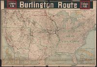
Beinecke Rare Book and Manuscript Library > [United States] Burlington Route / Burlington R.R.
Published / Created:
[1920?].
Call Number:
75 1920
Container / Volume:
BRBL_00407A
Image Count:
2
Resource Type:
Maps, Atlases & Globes
Found in:
Beinecke Rare Book and Manuscript Library > [United States] / printed by Rand McNally & Company for free distribution through the newspapers represented by Frederic J. Haskin ; photographs by Harris & Ewing.
Published / Created:
1866
Call Number:
75 1866H
Container / Volume:
BRBL_00403
Image Count:
1
Resource Type:
Maps, Atlases & Globes
Found in:
Beinecke Rare Book and Manuscript Library > [United States] / drawn by A. Lindenkohl ; Chas. G. Krebs, Litho.
Published / Created:
1848?]
Call Number:
75 1848C
Container / Volume:
BRBL_00399
Image Count:
1
Resource Type:
Maps, Atlases & Globes
Found in:
Beinecke Rare Book and Manuscript Library > [United States Treaties] E. Gilman, draftsman. P.S. Duval's Steam lith. press, Philadelphia.
Published / Created:
1848?]
Call Number:
75 1848B
Container / Volume:
BRBL_00399
Image Count:
1
Resource Type:
Maps, Atlases & Globes
Found in:
Beinecke Rare Book and Manuscript Library > [United States Treaties] E. Gilman, draftsman. P.S. Duval's Steam lith. press, Philadelphia.
Creator:
Published / Created:
ca. 1855
Call Number:
WA Prints Folio 6
Container / Volume:
Report of explorations in California for railroad routes, to connect with the routes near the 35th and 32nd parallels of north latitude by Lieutenant R. S. Williamson1853. Volume V from Reports of explorations and surveys, to ascertain the most practicab
Image Count:
1
Found in:
Beinecke Rare Book and Manuscript Library > [U.S.P.R.R. Exp. & Surveys. Cal.] Section 9 Sheet VI Geological Section from the Colorado River to the Pacific Ocean Explored by Lieut. R.S. Williamson Corps of Topl. Engrs. 1853 Constructed from Observations in the Vicinity of the Route from the Mouth of
Creator:
Published / Created:
ca. 1855
Call Number:
WA Prints Folio 3
Container / Volume:
Report of explorations in California for railroad routes, to connect with the routes near the 35th and 32nd parallels of north latitude by Lieutenant R. S. Williamson1853. Volume V from Reports of explorations and surveys, to ascertain the most practicab
Image Count:
1
Found in:
Beinecke Rare Book and Manuscript Library > [U.S.P.R.R. Exp. & Surveys. Cal.] Section 5, Sheet III. Geological Section of the Sierra Nevada at the Tejon Pass Explored by Lieut. R.S. Williamson Corps of Top. Engrs. 1853 Prepared in the Office of Pacific Rail Road Explorations & Surveys War Departme
Creator:
Published / Created:
ca. 1855
Call Number:
WA Prints Folio 4
Container / Volume:
Report of explorations in California for railroad routes, to connect with the routes near the 35th and 32nd parallels of north latitude by Lieutenant R. S. Williamson1853. Volume V from Reports of explorations and surveys, to ascertain the most practicab
Image Count:
1
Found in:
Beinecke Rare Book and Manuscript Library > [U.S.P.R.R. Exp. & Surveys. Ca.] Section 6. Sheet IV. Geological Section Along the Tejon Ravine Explored by Lieut R.S. Williamson Corps of Topl. Engrs. 1853 from the Tulare Valley and the Tejon Depot Camp to Taheechaypah Prairie Prepared in the Office of
Creator:
Published / Created:
ca. 1855
Call Number:
WA Prints Folio 2
Container / Volume:
Report of explorations in California for railroad routes, to connect with the routes near the 35th and 32nd parallels of north latitude by Lieutenant R. S. Williamson1853. Volume V from Reports of explorations and surveys, to ascertain the most practicab
Image Count:
1
Found in:
Beinecke Rare Book and Manuscript Library > [U.S.P.R.R. Exp. & Surveys. CAL.] Section 5, Sheet III. Geological Section of the Sierra Nevada at the Tejon Pass Explored by Lieut. R.S. Williamson Corps of Topl. Engrs. 1853 Prepared in the Office of Pacific Rail Road Explorations & Surveys War Departm
Published / Created:
1840-1844.
Call Number:
23 1844
Container / Volume:
BRBL_00020
Image Count:
3
Resource Type:
Maps, Atlases & Globes
Found in:
Beinecke Rare Book and Manuscript Library > [U.S. Exploring Expedition Pacific Ocean] Engraved by Sherman and Smith, New York. By the U.S. Ex.Ex.
Published / Created:
188-]
Call Number:
754GM 1880
Container / Volume:
BRBL_00419
Image Count:
1
Resource Type:
Maps, Atlases & Globes
Found in:
Beinecke Rare Book and Manuscript Library > [Two maps showing the southern Atlantic states to point out the transportation routes to the Seaboard Central and Seaboard Southern routes].
Published / Created:
1825
Call Number:
23cea 1825A
Container / Volume:
BRBL_00021
Image Count:
2
Resource Type:
Maps, Atlases & Globes
Found in:
Beinecke Rare Book and Manuscript Library > [Two charts of the Pacific Ocean, showing the Northwestern America and Sandwich Islands and ports].
Published / Created:
[1940?]
Call Number:
456 1940A
Container / Volume:
BRBL_00259
Image Count:
1
Resource Type:
Maps, Atlases & Globes
Found in:
Beinecke Rare Book and Manuscript Library > [Transylvania] / Entworfen von Robert Csallner.
Published / Created:
[1940?]
Call Number:
456 1918A
Container / Volume:
BRBL_00259
Image Count:
1
Resource Type:
Maps, Atlases & Globes
Found in:
Beinecke Rare Book and Manuscript Library > [Transylvania] / Entworfen von Robert Csallner.
Published / Created:
[1940?]
Call Number:
456 1918
Container / Volume:
BRBL_00259
Image Count:
1
Resource Type:
Maps, Atlases & Globes
Found in:
Beinecke Rare Book and Manuscript Library > [Transylvania] / Entworfen von Robert Csallner.
Published / Created:
1873?]
Call Number:
844cbf 1873A
Container / Volume:
BRBL_00613
Image Count:
1
Resource Type:
Maps, Atlases & Globes
Found in:
Beinecke Rare Book and Manuscript Library > [Topographical map of central California].
Published / Created:
[1940?-1941]
Call Number:
42 1940
Container / Volume:
BRBL_00244
Image Count:
13
Resource Type:
Maps, Atlases & Globes
Found in:
Beinecke Rare Book and Manuscript Library > [Topographical map of Austria. 1: 25,000].
Branch:v1.60.98 ,Deployed:2024-04-24T10:14:36-04:00