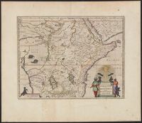
From the author's Atlas major. 1662., Includes ill. of animals and ornamental cartouche., Relief shown pictorially., and Verso: text with running title "Abyssinorvm Imperivm," page numbers "86", "85"; signature "Bb".
Publisher:
J. Blaeu,
Subject (Geographic):
Africa, Central--Maps--Early works to 1800 and Africa, Eastern--Maps--Early works to 1800
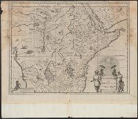
Appears in the author's Atlas major., Includes ill. of animals and ornamental cartouche., Relief shown pictorially., and Sheet measures 42.6 x 56.1 cm. Blank sheet (6.8 x 56 cm.) pasted to bottom.
Publisher:
J. Blaeu,
Subject (Geographic):
Africa, Central--Maps--Early works to 1800 and Africa, Eastern--Maps--Early works to 1800
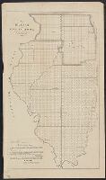
map shows detailed data concerning land districts (townships). For publisher compare Phillips, Lists of Maps, vol.II, page 328, item 5. and Preliminary record.
House executive document (United States. Congress. House) ; 38th Congress, 1st session, no. 1.
Description:
"House R. Ex. Doc. No. 1, 38th Cong., 1st Sess.", Includes "List of private grants finally surveyed.", Relief shown by hachures., and Shows drainage, townships, railroads, mines, oil springs, land grants, etc.
Publisher:
Department of the Interior, General
Subject (Geographic):
California--Maps and California--Surveys--Maps
Subject (Name):
Bien, Julius, 1826-1909
Subject (Topic):
Land grants--California--Maps and Mines and mineral resources--California--Maps
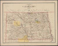
In two sheets., Includes inset of The Hawaiian Islands., and Relief shown by contours and spot heights; contour interval 40 ft.
Publisher:
Dept. of the Interior, U.S. Geological
Subject (Geographic):
Hawaii--Oahu and Oahu (Hawaii)--Maps
Subject (Name):
Birdseye, C. H. (Claude Hale), 1878-1941, Davis, Geo. R. (George R.), Fowler, A. T, Hawaii. Territorial Survey., Marshall, R. B. (Robert Bradford), 1867-1949, and U.S. Coast and Geodetic Survey