Skip to search
Skip to main content
Skip to first result
Search
You Searched For
"Interiors"
Format
cartographic
New Search
Search Results
Creator:
Published / Created:
[1980]
Call Number:
836 B51 1980
Container / Volume:
BRBL_00592
Image Count:
2
Resource Type:
Maps, Atlases & Globes
Alternative Title:
Bryce Canyon offizieller Führer mit Karte
Description:
"*GPO: 1980--311-309/28.", Includes text and ancillary map of "Bryce Amphitheater trailheads.", Panel title: Bryce Canyon., Relief shown by shading and spot heights., and Text, cross section, and col. ill. on verso.
Publisher:
The Service,
Subject (Geographic):
Bryce Canyon National Park (Utah)--Maps
Found in:
Beinecke Rare Book and Manuscript Library > Bryce Canyon National Park, Utah / National Park Service, U.S. Department of the Interior.
Creator:
Published / Created:
1925
Call Number:
743 L79 1925
Container / Volume:
BRBL_00395
Image Count:
1
Resource Type:
Maps, Atlases & Globes
Description:
Interior ."
Publisher:
Topographical Survey of Canada,
Subject (Geographic):
Great Slave Lake (N.W.T.)--Maps
Found in:
Beinecke Rare Book and Manuscript Library > Map of Lockhart River Basin, Great Slave Lake District, Northwest Territories : including the head waters of Thelon, Back and Coppermine Rivers / compiled, drawn and printed at the Topographical Survey of Canada.
Creator:
Published / Created:
1940
Call Number:
80gcg 1940
Container / Volume:
BRBL_00537
Image Count:
1
Resource Type:
Maps, Atlases & Globes
Description:
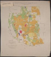
"Albuquerque drafting office C.C.C., December 1940, Troy Robinson, enrollee draftsman." and Includes national forests, military and Indian reservations, grazing districts, and national parks and monuments.
Publisher:
The Service,
Subject (Topic):
Grazing districts--West (U.S.)--Maps
Found in:
Beinecke Rare Book and Manuscript Library > Grazing districts under Taylor Grazing Act / United States Department of the Interior, Grazing Service.
Creator:
Published / Created:
1918
Call Number:
848 M41 1918
Container / Volume:
BRBL_00634
Image Count:
1
Resource Type:
Maps, Atlases & Globes
Alternative Title:
Alaska ; 602 A and Lower Matanuska Valley, Alaska
Description:
"Surveyed in 1909 and 1913 ; topography by Alaskan Branch, R.H. Sargent, topographic engineer.", Includes regional location map., and Relief shown by contours and spot heights.
Publisher:
The Survey,
Subject (Geographic):
Matanuska River Valley (Alaska)--Maps
Found in:
Beinecke Rare Book and Manuscript Library > Topographic map of Lower Matanuska Valley, Alaska / Department of the Interior, U.S. Geological Survey.
Creator:
Published / Created:
12th May 1794.
Call Number:
71 1794P
Container / Volume:
BRBL_00726
Image Count:
2
Resource Type:
Maps, Atlases & Globes
Description:
Copy 3: Interiors hand colored. Stamp
Publisher:
Publish'd by Laurie & Whittle, No. 53 Fleet Street,
Subject (Geographic):
North America--Maps--Early works to 1800.
Subject (Name):
Brown, Horace--Stamp. and Laurie & Whittle
Subject (Topic):
British--America--Maps--Early works to 1800.
Found in:
Beinecke Rare Book and Manuscript Library > A new map of North America with the West India Islands : divided according to the preliminary articles of peace, signed at Versailles, 20 Jan. 1783, wherein are particularly distinguished the United States, and the several provinces, governments &ca which
Creator:
Published / Created:
1869
Call Number:
848 1869
Container / Volume:
BRBL_00630
Image Count:
1
Resource Type:
Maps, Atlases & Globes
Description:
the interior from a reconnaissance by W.H
Publisher:
U.S. Coast Survey,
Subject (Geographic):
Alaska--Maps and Yukon Territory--Maps
Subject (Name):
Dall, William Healey, 1845-1927 and Lindenkohl, H. (Henry)
Found in:
Beinecke Rare Book and Manuscript Library > Alaska and adjoining territory / drawn by H. Lindenkohl.
Creator:
Published / Created:
May 1755.
Call Number:
755 1755B
Container / Volume:
BRBL_00427
Image Count:
1
Resource Type:
Maps, Atlases & Globes
Description:
northern Florida, and the interior as far west
Publisher:
Thos. Jefferys,
Subject (Geographic):
France--Colonies--America--Maps--Early works to 1800, Great Britain--Colonies--America--Maps--Early works to 1800, and North America--Maps--Early works to 1800
Subject (Name):
Anville, Jean Baptiste Bourguignon d', 1697-1782
Found in:
Beinecke Rare Book and Manuscript Library > North America from the French of Mr. D'Anville : improved with the back settlements of Virginia and course of Ohio : illustrated with geographical and historical remarks.
Creator:
Published / Created:
[1918]
Call Number:
844fcm Y83 1918
Container / Volume:
BRBL_00615
Image Count:
1
Resource Type:
Maps, Atlases & Globes
Alternative Title:
Yosemite Valley, Yosemite National Park, California
Description:
Interior .
Publisher:
U.S. Geological Survey,
Subject (Geographic):
Yosemite Valley (Calif.)--Maps
Subject (Name):
Douglas, Edward Morehouse, 1855-1932, Marshall, R. B. (Robert Bradford), 1867-1949, Matthes, François, 1874-1948, and Urquhart, C. F
Found in:
Beinecke Rare Book and Manuscript Library > Map of Yosemite Valley, Yosemite National Park, California, Mariposa County / U.S. Geological Survey ; State of California ; E.M. Douglas, geographer ; R.B. Marshall, in charge of section ; topography by F.E. Matthes ; triangulation by C.F. Urquhart.
Creator:
Published / Created:
1861
Call Number:
754EG 1861
Container / Volume:
BRBL_00419
Image Count:
1
Resource Type:
Maps, Atlases & Globes
Description:
Interior , Washington, Sept. 9th, 1861. After a
Publisher:
Henry S. Graham,
Subject (Geographic):
Southern States--Maps
Subject (Topic):
Slavery--Southern States--Maps
Found in:
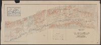
Beinecke Rare Book and Manuscript Library > Map showing the distribution of the slave population of the southern states of the United States, compiled from the census of 1860 / drawn by E. Hergesheimer ; engr. by Th. Leonhardt.
Branch:v1.61.8 ,Deployed:2024-06-20T11:15:15-04:00