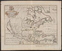
"Dedicated to His Highness William Duke of Glocester.", Dates inferred from variant listed in Tooley's Mapping of America, dated "[1700]" and variant in Phillips' Maps of America, described as in 1722 ed. of Wells' A new sett of maps., and Library's copy stampe
Publisher:
s.n.,
Subject (Geographic):
Caribbean Area--Maps--Early works to 1800 and North America--Maps--Early works to 1800
Subject (Name):
Burghers, M, University of Oxford, and Wells, Edward, 1667-1727. New sett of maps both of antient and present geography
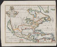
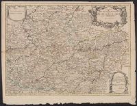
Appears in Senex's New general atlas., Cross collection no. 74., Dedicated to John Richmond Webb; dedication shows evidence of previous cartographer's name being removed and replaced by that of John Senex., London meridian., Relief shown pictorially., and Shows boundaries, rivers, forests and settlements.
Publisher:
John Senex],
Subject (Geographic):
Cambrai (France)--Maps--Early works to 1800, Hainaut (County)--Maps--Early works to 1800, and Namur (Belgium)--Maps--Early works to 1800
Subject (Name):
Senex, John, d. 1740, dedicator, Senex, John, d. 1740. New general atlas, and Webb, John Richmond, dedicatee
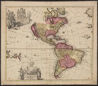
Imperfect; chipped along edges, with some loss of text. Manuscript number "j20" in upper right corner. Left side of Matthaeus Seutter map "Le pays de Perou et Chili ..." pasted onto verso., Includes five bar scales., and Relief shown pictorially.
Publisher:
Venalis prostat Augustae Vindel. apud Ieremiam Wolff,