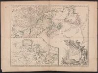
Robert de Vaugondy, Gilles, 1688-1766, cartographer.
Call Number:
73 1785
Image Count:
1
Resource Type:
Maps, Atlases & Globes
Alternative Title:
Partie de l'Amérique septent[rionale] qui comprend la Nouvelle France ou le Canada
Description:
Decorative title cartouche by Graux., Fourth state with date in cartouce removed., From the author's Atlas universel., Inset of "Supplement pour les lacs du Canada" (scale approximately 1:5,500,000)., Relief shown pictorially., and Watermark.
Subject (Geographic):
Great Lakes Region (NorthAmerica
Subject (Name):
Robert de Vaugondy, Gilles, 1688-1766. Atlas universel.
The West-India pilot: containing piloting directions for Port Royal and Kingston harbours in
Image Count:
1
Subject (Geographic):
Atlantic Ocean --Maps --Early works to 1800, Central America --Maps --Early works to 1800, Providence Island (Colombia) --Maps, and Santa Catalina Island (Colombia)
Subject (Topic):
Harbors --Atlantic Coast (NorthAmerica
Collection Created:
London : Printed for the author and sold by S. Hooper ..., MDCCLXXI [1771]
The West-India pilot: containing piloting directions for Port Royal and Kingston harbours in
Image Count:
1
Subject (Geographic):
Atlantic Ocean --Maps --Early works to 1800, Santo Domingo (Dominican Republic) --Maps --Early works to 1800, and West Indies --Maps --Early works to 1800
Subject (Topic):
Harbors --Atlantic Coast (NorthAmerica
Collection Created:
London : Printed for the author and sold by S. Hooper ..., MDCCLXXI [1771]