Search
You Searched For
Search Results
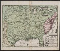
- Creator:
- Jefferys, Thomas, d. 1771
- Published / Created:
- May 1755.
- Call Number:
- 755 1755B
- Container / Volume:
- BRBL_00427
- Image Count:
- 1
- Resource Type:
- Maps, Atlases & Globes
- Subject (Geographic):
- North America--Maps--Early works to
- Found in:
- Beinecke Rare Book and Manuscript Library > North America from the French of Mr. D'Anville : improved with the back settlements of Virginia and course of Ohio : illustrated with geographical and historical remarks.
- Published / Created:
- [1734?]
- Call Number:
- 755 1734
- Container / Volume:
- BRBL_00426
- Image Count:
- 1
- Resource Type:
- Maps, Atlases & Globes
- Subject (Geographic):
- North America--Maps--Early works to
- Found in:
- Beinecke Rare Book and Manuscript Library > Novissima tabula regionis Ludovicianae, gallice dictae la Louisiane ... / delineata ... â Guil. Insulano ... ; M.L. [?] sc.
- Creator:
- Bonne, Rigobert, 1727-1794
- Published / Created:
- [1776?]
- Call Number:
- 71 1776C
- Container / Volume:
- BRBL_00365
- Image Count:
- 1
- Resource Type:
- Maps, Atlases & Globes
- Subject (Geographic):
- North America--Maps--Early works to
- Found in:
- Beinecke Rare Book and Manuscript Library > Partie de l'Amerique septentrionale : qui comprend le Canada, la Louisiane, le Labrador, le Groenland, la Nouvelle Angleterre, la Floride &c. / projettée et assujettie aux observations, par Mr. Bonne.
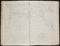
- Published / Created:
- 1720
- Call Number:
- 1974 Folio 72
- Collection Title:
- The English pilot: describing the West-India navigation, from Hudson's-Bay to the river Amazones
- Image Count:
- 1
- Subject (Geographic):
- Atlantic Coast (North America) --Maps
- Found in:
- Beinecke Rare Book and Manuscript Library > The harbour of Casco Bay and islands adjacent
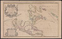
- Creator:
- Berry, William, fl. 1669-1708
- Published / Created:
- 1680
- Call Number:
- 71 1680
- Container / Volume:
- BRBL_00360
- Image Count:
- 1
- Resource Type:
- Maps, Atlases & Globes
- Description:
- Ireland, this map of North America
- Subject (Geographic):
- North America--Maps--Early works to
- Found in:
- Beinecke Rare Book and Manuscript Library > North America divided into its principall parts where are distinguished the severall states which belong to the English, Spanish, and French / described by Sanson ; corrected and amended by William Berry.
- Creator:
- Gibson, J. (John)
- Call Number:
- 1973 Folio 67
- Collection Title:
- The West-India pilot: containing piloting directions for Port Royal and Kingston harbours in
- Image Count:
- 1
- Subject (Topic):
- Harbors --Atlantic Coast (North America
- Found in:
- Beinecke Rare Book and Manuscript Library > Aiguiade de Port o Rico
- Call Number:
- 1973 Folio 67
- Collection Title:
- The West-India pilot: containing piloting directions for Port Royal and Kingston harbours in
- Image Count:
- 1
- Subject (Topic):
- Harbors --Atlantic Coast (North America
- Found in:
- Beinecke Rare Book and Manuscript Library > Chart of the Bay of Honduras
- Call Number:
- 1973 Folio 67
- Collection Title:
- The West-India pilot: containing piloting directions for Port Royal and Kingston harbours in
- Image Count:
- 1
- Subject (Topic):
- Harbors --Atlantic Coast (North America
- Found in:
- Beinecke Rare Book and Manuscript Library > Island of Old Providence
- Call Number:
- 1973 Folio 67
- Collection Title:
- The West-India pilot: containing piloting directions for Port Royal and Kingston harbours in
- Image Count:
- 1
- Subject (Topic):
- Harbors --Atlantic Coast (North America
- Found in:
- Beinecke Rare Book and Manuscript Library > Plan de la Rade du Port Paix