2nd state. Distinguishing feature of 2nd state: "Title changed slightly to read 'An accurate map of the British Colonies...'" (McCorkle 111)., 755 1756F: Verso: Stamped "Oct 23 1959"., Printed text in left and right margins., and Published separately as broadsid
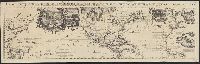
In top margin of sheet 1: Le tout pour l'intelligence des dissertations suivantes., Includes portraits of explorers, illustrations of indigenous peoples, wildlife, flora, historical notes, and ecclesiastical plot ownerships in Havana and Veracruz., and Shows sa
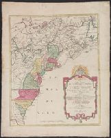
Although the map bears the date of 1755, it was not published until 1769., Dutch edition of Palairet's Carte des possessions angloises & francoises ... [1755]., From Isaak Tirion, and Hand col. Sheet measures 44 x 54 cm. Accompanied by ms. note by Henry Stevens.
Publisher:
By Isaak Tirion,
Subject (Geographic):
NorthAmerica--Maps--Early works to
Subject (Name):
Palairet, Jean, 1697-1774. Carte des possessions angloises & francoises du continent de l'Amerique Septentrionale
Subject (Topic):
British--America--Maps--Early works to 1800 and French--America--Maps--Early works to 1800
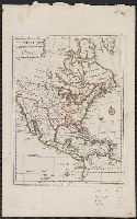
755 1755Z: Hand col. Sheet measures 44 x 54 cm., Although the map bears the date of 1755, it was not published until 1769., Dutch edition of Palairet's Carte des possessions angl, and Hand col. Sheet measures 44 x 54 cm. Accompanied by ms. note by Henry Stevens.
Publisher:
By Isaak Tirion,
Subject (Geographic):
NorthAmerica--Maps--Early works to
Subject (Name):
Palairet, Jean, 1697-1774. Carte des possessions angloises & francoises du continent de l'Amerique Septentrionale
Subject (Topic):
British--America--Maps--Early works to 1800 and French--America--Maps--Early works to 1800
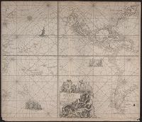
"Met Priviligie voor 15 Iaar.", From Keulen's Groote nieuwe vermeerderde zee-atlas ofte water-waereld / Johannes van Keulen., Map, State 1. Imperfect: small hole in lower right corner, with no loss of text. Cross Collection 69., and Title in cartouche.
Publisher:
By Ioannes van Keulen, aen de Nieuwe brugh in de Gekroonde Lootsman,
Subject (Geographic):
NorthAmerica--Maps--Early works to
Subject (Name):
Keulen, Johannes van, 1654-1715. Groote nieuwe vermeerderde zee-atlas ofte water-waereld
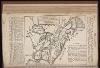
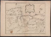
Covers Great Lakes region, extending as far southeast as Delaware Bay and Upper Chesapeake Bay., Mounted on linen. Stamp: Thorne Collection of Cartography and Geography. Stamp: Karpinski-von Wieser Map Collection., Prime meridian: Ferro., and Relief shown pictorially.
Publisher:
Chez R.J. Julien a l'Hôtel Soubise,
Subject (Geographic):
Great Lakes (NorthAmerica)--Maps
Subject (Name):
Julien, R. J. (Roche Joseph) and Thorne Collection of Cartogaphy and Geography Stamp