Search
You Searched For
Search Results
- Published / Created:
- [1710?]
- Call Number:
- 38 D74 1710
- Container / Volume:
- BRBL_00157
- Image Count:
- 1
- Resource Type:
- Maps, Atlases & Globes
- Found in:
- Beinecke Rare Book and Manuscript Library > A new and exact plan of the City of Douay with the Fort on the Scarpe. J. Harris Sculp.
- Published / Created:
- [1715?]
- Call Number:
- 38 1715
- Container / Volume:
- BRBL_00151
- Image Count:
- 1
- Resource Type:
- Maps, Atlases & Globes
- Found in:
- Beinecke Rare Book and Manuscript Library > A new map of France ... John Senex.
- Creator:
- Senex, John, d. 1740
- Published / Created:
- 1714
- Call Number:
- 3191 1714
- Container / Volume:
- BRBL_00683
- Image Count:
- 2
- Resource Type:
- Maps, Atlases & Globes
- Found in:
- Beinecke Rare Book and Manuscript Library > A new map of Great Britain : corrected from the observations communicated to the Royal Society at London / by John Senex, F.R.S.
- Published / Created:
- 1714
- Call Number:
- 327 1714
- Container / Volume:
- BRBL_00072
- Image Count:
- 1
- Resource Type:
- Maps, Atlases & Globes
- Found in:
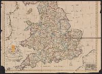
- Beinecke Rare Book and Manuscript Library > A new map of Ireland ... Herman Moll, Geographer 1714.
- Published / Created:
- 1714
- Call Number:
- 40 1714A
- Container / Volume:
- BRBL_00197
- Image Count:
- 1
- Resource Type:
- Maps, Atlases & Globes
- Found in:
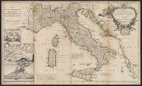
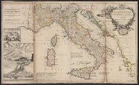
- Beinecke Rare Book and Manuscript Library > A new map of Italy ... post roads ... / H. Moll, geographer.
- Published / Created:
- 1714
- Call Number:
- 40 1714A
- Container / Volume:
- BRBL_00197
- Image Count:
- 1
- Resource Type:
- Maps, Atlases & Globes
- Found in:
- Beinecke Rare Book and Manuscript Library > A new map of Italy ... post roads ... / H. Moll, geographer.
- Creator:
- Moll, Herman, -1732
- Published / Created:
- 1714
- Call Number:
- 40 1714
- Container / Volume:
- BRBL_00196
- Image Count:
- 1
- Resource Type:
- Maps, Atlases & Globes
- Found in:
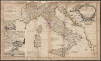
- Beinecke Rare Book and Manuscript Library > A new map of Italy : distinguishing all the sovereignties in it, whether states, kingdoms, dutchies, principalities, republicks &c. With the post roads, and many remarks not extant in any map. According to ye newest and most exact observations / by H. Mol
- Creator:
- Wells, Edward, 1667-1727
- Published / Created:
- between 1700 and 1722?]
- Call Number:
- 71 1722
- Container / Volume:
- BRBL_00362
- Image Count:
- 1
- Resource Type:
- Maps, Atlases & Globes
- Found in:
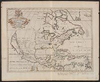
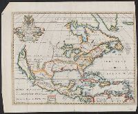
- Beinecke Rare Book and Manuscript Library > A new map of North America shewing its principal divisions, chief cities, townes, rivers, mountains &c. / delin. M. Burg. ; sculpt. Univ. Oxon.
- Creator:
- Wells, Edward, 1667-1727
- Published / Created:
- between 1700 and 1722?]
- Call Number:
- 71 1722 A
- Container / Volume:
- BRBL_00362
- Image Count:
- 1
- Resource Type:
- Maps, Atlases & Globes
- Found in:
- Beinecke Rare Book and Manuscript Library > A new map of North America shewing its principal divisions, chief cities, townes, rivers, mountains &c. / delin. M. Burg. ; sculpt. Univ. Oxon.
- Published / Created:
- 1719
- Call Number:
- 755 1719
- Container / Volume:
- BRBL_00425
- Image Count:
- 1
- Resource Type:
- Maps, Atlases & Globes
- Found in:
- Beinecke Rare Book and Manuscript Library > A new map of the English empire in America viz. Virginia, Maryland, Carolina, Pennsylvania, New York, New Jersey, New England, Newfoundland, New France, &c. Revised by Ion. Senex, 1719.