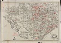
"No. 109-1947.", "S. 40.", Insets: Road to Fraser's Hill farm. Scale [1:6 336]. 8 chains to an in. -- Sketch of road from the Gap to Fraser's Hill. Scale [1:12 672]. 16 chains to an in., and Map of Bukit Fraser showing transportation, water features, recreation
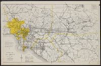
"Constructed between 1933 and 1936, and originally named Boulder Dam, it [Hoover Dam] was renamed in 1947...."--"Hoover Dam," Encyclopedia Britannica Online, accessed 5/15/2002. and Includes ill. showing "Boulder Dam" in relation to L.A. and text of "Dominant factors."
Publisher:
California Map Company, 1120 Story Building, 610 So. Broadway,
Subject (Geographic):
Los Angeles (Calif.)--Maps, Los Angeles Metropolitan Area (Calif.)--Maps, Orange County (Calif.)--Maps, Riverside County (Calif.)--Maps, and San Bernardino County (Calif.)--Maps
Subject (Topic):
Roads--California--Los Angeles Metropolitan Area--Maps
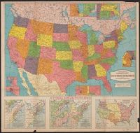
"5365" -- lower right corner., 3 air lines distance tables, 2 population tables, and a table of historical data about the states and territories, and Includes 8 inset maps and 5 ancillary maps depicting historical information for the U.S. between 1606 and 1917.