Search
You Searched For
Search Results
- Published / Created:
- 1820?
- Call Number:
- 764 SA32 1820
- Container / Volume:
- BRBL_00459
- Image Count:
- 1
- Resource Type:
- Maps, Atlases & Globes
- Found in:
- Beinecke Rare Book and Manuscript Library > Plan of the town of Salem in the Commonwealth of Massachusetts from actual Surveys made in the years 1796 & 1804; with the improvements and alterations since that period as Surveyed by Jonathan P. Saunders.
- Published / Created:
- [1820?]
- Call Number:
- 76 1820
- Container / Volume:
- BRBL_00443
- Image Count:
- 1
- Resource Type:
- Maps, Atlases & Globes
- Found in:
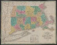
- Beinecke Rare Book and Manuscript Library > Map of the States of Maine, New Hampshire, Vermont, Massachusetts, Connecticut & Rhode Island by H. S. Tanner ... 14th day of Novr. 1820
- Published / Created:
- 1825
- Call Number:
- 76 1825A
- Container / Volume:
- BRBL_00444
- Image Count:
- 1
- Resource Type:
- Maps, Atlases & Globes
- Abstract:
- Massachusetts, Connecticut and Rhode Island, divided
- Alternative Title:
- Massachusetts Connecticut & Rhode
- Description:
- Cover title: Massachusetts Connecticut
- Subject (Geographic):
- Massachusetts--Maps.
- Found in:
- Beinecke Rare Book and Manuscript Library > Map of Massachusetts Connecticut and Rhode Island [cartographic material] : constructed from the latest authorities. 1825. / Drawn by D.H. Vance. Engraved by J.H. Young.
- Published / Created:
- 1825
- Call Number:
- 76 1825
- Container / Volume:
- BRBL_00444
- Image Count:
- 1
- Resource Type:
- Maps, Atlases & Globes
- Found in:
- Beinecke Rare Book and Manuscript Library > Map of the States of Maine, New Hampshire, Vermont, Massachusetts, Connecticut & Rhode Island by H. S. Tanner c.1820, improved to 1825.
- Published / Created:
- [1827]
- Call Number:
- 76 1827A
- Container / Volume:
- BRBL_00444
- Image Count:
- 1
- Resource Type:
- Maps, Atlases & Globes
- Found in:
- Beinecke Rare Book and Manuscript Library > Map of Massachusetts, Connecticut and Rhode Island. Constructed from the Latest Authorities.
- Published / Created:
- [1827]
- Call Number:
- 76 1827
- Container / Volume:
- BRBL_00444
- Image Count:
- 1
- Resource Type:
- Maps, Atlases & Globes
- Found in:
- Beinecke Rare Book and Manuscript Library > Map of the States of Maine, New Hampshire, Vermont, Massachusetts, Connecticut & Rhode Island by H. S. Tanner, 1827.
- Creator:
- Jocelyn, N
- Published / Created:
- 1828
- Call Number:
- 767gma 1828
- Container / Volume:
- BRBL_00476
- Image Count:
- 1
- Resource Type:
- Maps, Atlases & Globes
- Subject (Geographic):
- /Massachusetts)--Maps
- Found in:
- Beinecke Rare Book and Manuscript Library > Map exhibiting the Farmington & Hampshire & Hampden canals [map] : together wth the line of their proposed continuation through the Valley of the Connecticut River to Canada / engraved ... by N. & S.S. Jocelyn.
- Creator:
- Dorman, Moses, author.
- Published / Created:
- 1830
- Call Number:
- 764 An23 1830
- Image Count:
- 1
- Resource Type:
- Maps, Atlases & Globes
- Description:
- portion of the City of Lawrence, Massachusetts.
- Subject (Topic):
- Landowners--Massachusetts--Andover
- Found in:
- Beinecke Rare Book and Manuscript Library > A plan of Andover taken for the town / by Moses Dorman, Jr.
- Published / Created:
- [1831?]
- Call Number:
- 764 B63 1831
- Container / Volume:
- BRBL_00454
- Image Count:
- 1
- Resource Type:
- Maps, Atlases & Globes
- Found in:
- Beinecke Rare Book and Manuscript Library > A Map of the Town of Bolton in the County of Worcester and the Commonwealth of Massachusetts. Surveyed by Silas Holman in the Year 1831.