Account of the voyages undertaken by the order of His present Majesty for making discoveries in the
Container / Volume:
BRBL_00683
Image Count:
1
Resource Type:
Maps, Atlases & Globes
Alternative Title:
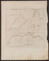
Joseph Freewills Islands. and South end of Mindanao.
Description:
Cross Collection 71., Depths shown by soundings., and From Hawkesworth's Account of the voyages undertaken by the order of His present Majesty for making discoveries in the Southern Hemisphere. London: Printed for W. Strahan and T. Cadell, 1773; v. 1, facing p.
Subject (Geographic):
Mapia Islands (Indonesia)--Maps--Early works to 1800 and Mindanao Island (Philippines)--Maps--Early works to 1800
Subject (Name):
Carteret, Philip, d. 1796 and Cook, James, 1728-1779
Subject (Topic):
Nautical charts--Indonesia--Mapia Island--Early works to 1800 and Nautical charts--Philippines--Mindanao Island--Early works to 1800
Copper-engraved outline-chart. Coasts outlined in color by hand. Water-line at low tide outlined in blue on larger islands. Beaches, rocky headlands, sandhills, hidden tocks, anchorages, soundings. Jason's track around the island and into Port Stephens. and I
From Jefferys's The American atlas ... London : Printed and sold by R. Sayer and J. Bennett, 1776., Hand col. Sheet measures 55.1 x 73.5 cm. Stamped no. on verso: 12. Cross Collection no. 160., and Relief shown pictorially. Depths shown by soundings.
Publisher:
By Thomas Jefferys, geographer to the King, printed for Robt. Sayer & Jno. Bennett,
Subject (Geographic):
Newfoundland, Island of (N.L.)--Maps--Early works to 1800
Subject (Name):
Cook, James, 1728-1779, Jefferys, Thomas, d. 1771. American atlas, Lane, Michael, fl. 1768-1784, and Robert Sayer and John Bennett (Firm)