Skip to search
Skip to main content
Skip to first result
Search
You Searched For
Date
1710 - 1719
Format
cartographic
Date Created
1710 to 1719
New Search
Search Results
Published / Created:
17--?]
Call Number:
32 Sa34 553
Container / Volume:
BRBL_00054
Image Count:
1
Resource Type:
Maps, Atlases & Globes
Description:
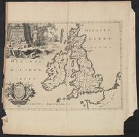
Insets: East view of the city & castle of Old Sarum, text.
Subject (Geographic):
England--Maps--Early works to 1800
Found in:
Beinecke Rare Book and Manuscript Library > An exact plan and section of Old Sarum also the East view of that antient City as it then stood (before its reduction) in 553. Taken from the best authorities by F. Merryweather.
Creator:
Published / Created:
[1714?]
Call Number:
3190 No. 4
Container / Volume:
BRBL_00041
Image Count:
1
Resource Type:
Maps, Atlases & Globes
Description:
Appears in Pieter van der Aa's La Galerie Agréable du Monde [1714?]. and Prime meridian: Ferro.
Publisher:
Apud Peter um Vander Aa,
Subject (Geographic):
British Isles--Early works to 1800--Maps
Found in:
Beinecke Rare Book and Manuscript Library > Antiquorum Britanniae Episcopatuum geographica descriptio.
Published / Created:
1710?]
Call Number:
52 1710
Container / Volume:
BRBL_00282
Image Count:
1
Resource Type:
Maps, Atlases & Globes
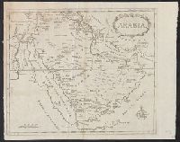
Subject (Geographic):
Arabian Peninsula--Maps--Early works to 1800
Found in:
Beinecke Rare Book and Manuscript Library > Arabia.
Creator:
Published / Created:
[ca. 1710]
Call Number:
1983 Folio 23
Collection Title:
[Atlas factice of 50 maps, primarily by Johann Baptist Homann and/or issued by the Homann Erben
Image Count:
1
Alternative Title:
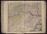
Basse Autriche qui se divise en 4. quartieres and Basse Avtriche qui se divise en 4. quartieres
Publisher:
[Johann Baptist Homann]
Subject (Geographic):
Austria --Maps --Early works to 1800
Collection Created:
[Nuremberg : Homann Erben, 1710-1786]
Found in:
Beinecke Rare Book and Manuscript Library > Archiducatus Austriae [cartographic material] : inferioris in omnes suas quadrantes ditiones divisi nova et exacta tabula / e conatibus Io. Baptistae Homanni
Creator:
Published / Created:
[ca. 1710]
Call Number:
1983 Folio 23
Collection Title:
[Atlas factice of 50 maps, primarily by Johann Baptist Homann and/or issued by the Homann Erben
Image Count:
1
Alternative Title:
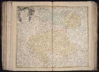
Haute Autriche qui se divise en 4 quartieres and Havte Avtriche qui se divise en 4 quartieres
Publisher:
[Johann Baptist Homann]
Subject (Geographic):
Austria --Maps --Early works to 1800
Collection Created:
[Nuremberg : Homann Erben, 1710-1786]
Found in:
Beinecke Rare Book and Manuscript Library > Archiducatus Austriae superioris in suas quadrantes ditiones exacte divisi accuratissima tabula [cartographic material] / ex amplissima Rev. Dn. Georg Matth. Vischer Sac. Caes. Mai. (Leopoldi Glor.mae Mem.) Geogra. ; desumta et exhibita a Ioh. Baptista Ho
Creator:
Published / Created:
[approximately 1715]
Call Number:
BrSides Double Folio 2019 36
Image Count:
1
Resource Type:
Maps, Atlases & Globes
Description:
Relief shown pictorially. and Watermark. Manuscript number in right corner: 50. From the Karpinski-von Wieser Map Collection.
Publisher:
[Johann Baptist Homann]
Subject (Geographic):
Cologne (Electorate)--Maps--Early works to 1800., Jülich-Berg--Maps--Early works to 1800., and North Rhine-Westphalia (Germany)--Maps--Early works to 1800.
Subject (Name):
Catholic Church.--Archdiocese of Cologne (Germany)--Maps--Early works to 1800
Found in:
Beinecke Rare Book and Manuscript Library > Archiepiscopatus et Electoratus Coloniensis ut et Ducatuum Juliacensis et Montensis nec non comitatus Meursiae nova tabula / excudente Iohan Baptista Homanno.
Published / Created:
[1710?]
Call Number:
3764 1710
Image Count:
2
Resource Type:
Maps, Atlases & Globes
Subject (Geographic):
Aargau (Switzerland)--Maps--Early works to 1800
Found in:
Beinecke Rare Book and Manuscript Library > Argow cum parte Merid. Zurichgow Auctore Ger. Mercatore.
Creator:
Published / Created:
[1708-1725]
Call Number:
1983 Folio 51
Collection Title:
Modern geography, or, All the known countries in the world : laid down from the latest observations
Image Count:
1
Publisher:
T. Bowles & T. Bowles & Son
Collection Created:
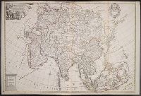
[London] : For T. Bowles & T. Bowles & Son, [1708-1725]
Found in:
Beinecke Rare Book and Manuscript Library > Asia, corrected from the observations communicated to the Royal Society at London and the Royal Academy at Paris
Creator:
Published / Created:
[approximately 1710]
Call Number:
BrSides Folio 2019 86
Image Count:
2
Resource Type:
Maps, Atlases & Globes
Description:
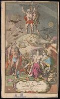
Imperfect: chipped. Accompanied by manuscript title page in Italian, "Nuovo Atlante sopra l'universo mondo ..." with imprint "Norinberga à spese dell' Autore stampato da Gio. Ernesto Adelbalner, 1714." and Title page for Johann Baptist Homann's Atlas novus terrarum orbis imperia.
Publisher:
[Johann Baptist Homann],
Subject (Name):
Homann, Johann Baptist, 1663-1724. Atlas novus terrarum orbis imperia.
Found in:
Beinecke Rare Book and Manuscript Library > Atlas novus terrarum orbis imperia, regna et status exactis tabulis geographicè demonstrans operâ Iohannis Baptistae Homanni ... Noribergae / Caspar Luycken fecit.
Creator:
Published / Created:
[1717]
Call Number:
1973 Folio 18
Image Count:
1
Resource Type:
Maps, Atlases & Globes
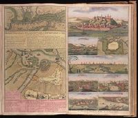
Alternative Title:
Accurate aftekening hoe de twee Legers geleegen hebben voor Belgrado, ent bomberderen en kanonneeren op malkanderen van den 2 tot den 14 Augustus anno 1717 and Nieuwe accurate kaart van de marse der Keyserlyke armee van Peter Wardien en Futak.
Description:
Backed with paper. Ms. no. in upper right corner [illegible due to trimming]. Sheet measures 53.8 x 62.4 cm. No. 74 of 87 maps bound together., On sheet with 1 other map ("Nieuwe accurate kaart van de marse der Keyserlyke armee van Peter Wardien en Futak ... tot voor Belgrado ... 9 tot den 19 Iuny anno 1717") and 7 bird's-eye views ("Belgrad," "Temeswar" [with map "De Stadt Temeswar"], "Temeswar" [2], "Wardien," "Offen v. Pest," "Sigeth," and "Citta e porto di Constantinopoli")., Relief shown pictorially., and With inset bird's-eye view of Belgrade in upper left corner.
Publisher:
By Gerard van Keulen, aen de Nieuwen Brugh,
Subject (Geographic):
Serbia--Maps--Early works to 1800.
Subject (Topic):
Austro-Turkish War, 1716-1718--Maps.
Found in:
Beinecke Rare Book and Manuscript Library > Attaque der Turkse galeyen en saiken, op de 2 keyserlyke oorlog scheepen op den 9 July voor gevallen op den Donau [cartographic material].
Branch:v1.61.6 ,Deployed:2024-06-12T09:55:33-04:00