Skip to search
Skip to main content
Skip to first result
Search
You Searched For
"Interiors"
Format
cartographic
New Search
Search Results
Creator:
Published / Created:
1925
Call Number:
737 L14 1925
Container / Volume:
BRBL_00385
Image Count:
1
Resource Type:
Maps, Atlases & Globes
Description:
Shows lot lines, roads & trails, contours (V.I 100 ft.) and gasoline car line.
Publisher:
Canada.Dept of the Interior ,
Subject (Geographic):
Lake Louise (Alta.)--Maps
Found in:
Beinecke Rare Book and Manuscript Library > Plan of Lake Louise and vicinity [map] / drawn and printed by the Topographical Survey of Canada.
Published / Created:
1910
Call Number:
736gc 1910
Container / Volume:
BRBL_00383
Image Count:
1
Resource Type:
Maps, Atlases & Globes
Publisher:
Dept. of the Interior ,
Subject (Geographic):
Manitoba--Maps
Found in:
Beinecke Rare Book and Manuscript Library > Sketch map showing timber conditions along part of the proposed route of the Hudson Bay Railway.
Published / Created:
1912]
Call Number:
739 V66 1912
Container / Volume:
BRBL_00391
Image Count:
1
Resource Type:
Maps, Atlases & Globes
Description:
Maps on p. 80: Regina; Victoria [scales 1:32,000]., Shows streets, railways, electric railway, city limits, churches and other major buildings., and Two atlas pages joined (p. 79 and 80); "Atlas of Canada" above top corners of each plate.
Publisher:
Department of the Interior ,
Subject (Geographic):
Regina (Sask.)--Maps, Vancouver (B.C.)--Maps, and Victoria (B.C.)--Maps
Found in:
Beinecke Rare Book and Manuscript Library > Vancouver.
Creator:
Published / Created:
1929
Call Number:
741 1929
Container / Volume:
BRBL_00395
Image Count:
1
Resource Type:
Maps, Atlases & Globes
Description:
Relief shown by spot heights.
Publisher:
Dept. of the Interior ,
Subject (Geographic):
Yukon--Maps
Subject (Name):
Chalifour, J. E
Found in:
Beinecke Rare Book and Manuscript Library > Yukon Territory.
Published / Created:
1912
Call Number:
734 Q31 1912
Container / Volume:
BRBL_00380
Image Count:
1
Resource Type:
Maps, Atlases & Globes
Description:
Ancillary maps of Halifax and St. John. and From Atlas of Canada (1912) pp. 69-70.
Publisher:
Dept. of the Interior ,
Subject (Geographic):
Québec (Province)--Maps
Found in:
Beinecke Rare Book and Manuscript Library > [Map of Québec]
Creator:
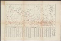
Interior . Railway Lands Branch
Published / Created:
[1913]
Call Number:
736 1913A
Container / Volume:
BRBL_00382
Image Count:
1
Resource Type:
Maps, Atlases & Globes
Alternative Title:
Elevators in Manitoba, Saskatchewan, and Alberta
Description:
"Correct to January 1st 1913.", Includes index., and Shows elevator capacities.
Publisher:
Department of the Interior , Canada,
Subject (Geographic):
Prairie Provinces--Maps
Subject (Name):
Lynch, F. C. C. (Francis Christopher Chisholm), 1884-
Subject (Topic):
Grain elevators--Prairie Provinces--Maps
Found in:
Beinecke Rare Book and Manuscript Library > Map showing elevators in Manitoba, Saskatchewan, and Alberta / prepared in the Railway Lands Branch, F.C.C. Lynch, Superintendent.
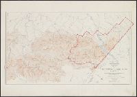
Creator:
Published / Created:
1918
Call Number:
737 W31 1914
Container / Volume:
BRBL_00385
Image Count:
1
Resource Type:
Maps, Atlases & Globes
Description:
Shows contours & spot hts., roads & trails, hydrographic detail.
Publisher:
Dept. of the Interior , Canada,
Subject (Geographic):
Waterton Lakes National Park (Alta.)--Maps
Subject (Name):
Canada. Dept. of the Interior
Found in:
Beinecke Rare Book and Manuscript Library > Map of Waterton Lakes Park, Alberta [map] / from photographic surveys by M. P. Bridgland, D.L.S. and A. O. Wheeler, B.C.L.S. ; drawn and printed at the Surveyor General's Office.
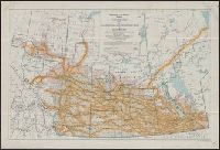
Creator:
Published / Created:
1922
Call Number:
73fcm 1922A
Container / Volume:
BRBL_00375B
Image Count:
1
Resource Type:
Maps, Atlases & Globes
Publisher:
Dept. of the Interior , Canada,
Subject (Topic):
Public lands--Prairie Provinces--Maps and Real property--Prairie Provinces--Maps
Found in:
Beinecke Rare Book and Manuscript Library > Map of Manitoba, Saskatchewan & Alberta : showing the number of quarter sections available for homestead entry, also number of quarter sections privately owned and unoccupied / prepared in the Natural Resources Intelligence Branch.
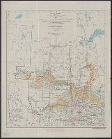
Creator:
Published / Created:
[1924]
Call Number:
73fcm 1924
Container / Volume:
BRBL_00375B
Image Count:
1
Resource Type:
Maps, Atlases & Globes
Publisher:
Dept. of the Interior , Canada,
Subject (Topic):
Public lands--Prairie Provinces--Maps and Real property--Prairie Provinces--Maps
Found in:
Beinecke Rare Book and Manuscript Library > Map of Manitoba, Saskatchewan and Alberta : showing the number of vacant quarter sections in each township / prepared in the Natural Resources Intelligence Service.
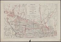
Creator:
Published / Created:
1919
Call Number:
737FCM P312 1919
Container / Volume:
BRBL_00386
Image Count:
1
Resource Type:
Maps, Atlases & Globes
Alternative Title:
Northern Alberta land districts
Description:
"Corrected to June 1919"
Publisher:
Canada. Dept. of the Interior ,
Subject (Geographic):
Alberta, Northern--Cadastral Maps
Found in:
Beinecke Rare Book and Manuscript Library > Map of Northern Alberta land districts [map] : comprising agencies of Peace River, Grande Prairie & Edmonton, showing number of quarter-sections in each township available for homestead entry / Natural Resources Intelligence Branch ; F.C.C. Lynch, superin
Branch:v1.61.8 ,Deployed:2024-06-20T11:14:48-04:00