From Streeter Collection -cat. no. 1132., Legend: To his Most Excellent Majesty George the IIID King of Great Britain, &c. &c. &c. This map is most humbly dedicated by most humble obidient & dutiful subject, John Collet., and This large scale map locates the re
From the American Military Pocket Atlas of the British Colonies, which now are or may be The Theatre of War. See 71.1774, Pamphlet box. and Insets: Plan of Charlestown and St. Augustine.
The American military pocket atlas : being an approved collection of correct maps, both general and
Image Count:
1
Alternative Title:
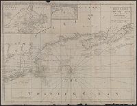
The Seat of war, in the northern colonies, containing the province of Quebec, Newfoundland, Nova-Scotia, New-England, New-York, New-Jersey, Pennsylvania, &ca
Description:
14th August 1776. and Teaching resource: Professor John Mack Faragher, History 141: The American West.
Publisher:
Printed for Robt. Sayer & Jno. Bennett, Map and Sea Chartsellers, No. 53, Fleet Street, as the Act directs
Subject (Geographic):
New England --Maps --Early works to 1800, North America --Maps --Early works to 1800, and United States --History --Revolution, 1775-1783 --Maps
Collection Created:
London : Printed for R. Sayer and J. Bennet, [1776]
The American military pocket atlas : being an approved collection of correct maps, both general and
Image Count:
1
Alternative Title:
The Seat of war, in the southern British colonies, comprehending North and South Carolina, Georgia, east and west Florida, &ca
Description:
15th Oct. 1776., Inset: Plan of Charlestown and plan of St. Augustine., and Teaching resource: Professor John Mack Faragher, History 141: The American West.
Publisher:
Printed for R. Sayer & J. Bennett, Map, Chart and Printsellers, No. 53 Fleet Street, as the Act directs
Subject (Geographic):
North America --Maps --Early works to 1800, Southern States --Maps --Early works to 1800, and United States --History --Revolution, 1775-1783 --Maps
Collection Created:
London : Printed for R. Sayer and J. Bennet, [1776]
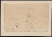
Color: pen and ink drawing with yellow detail., Lower half lacking., and Ms. cadastral map showing lands along Lake Champlain belonging to English soldiers.