Gouwen, Gilliam van der Visscher, Nicolaes, 1649-1702, creator
Published / Created:
[1690?]
Call Number:
1973 Folio 10
Image Count:
1
Resource Type:
Maps, Atlases & Globes
Alternative Title:
Landkaart vertonende het Graafschap Holland
Description:
Alternate title in upper margin: Landkaart vertonende het Graafschap Holland, seer dienstig om te reysen na : en van syne naburige provincien, als mede de Hoven van Soestdyk, 't Loo en Cleef / t' Amsteldam door Nicolaus Visscher met privilegie., Bar scales in Milliaria Germanica communia and Milliaria Gallica sive horae itineris., Ferro meridian., Includes col. ill. of figures in title cartouche., No. 44 of 69 maps bound together in composite atlas., Place-names in Dutch., Relief shown pictorially., and Scale [ca. 1:300 000].
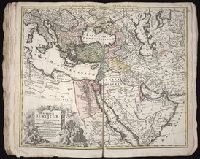
Dorn, Sebastian Hase, Johann Matthias, 1684-1742 Homann Erben (Firm)
Published / Created:
1744
Call Number:
1973 Folio 30
Collection Title:
[Atlas factice of 32 maps and 1 distance table, produced by the Homann Erben firm]
Image Count:
2
Alternative Title:
Carte d’Hongrie en general, contenant selon la division ancienne & methodique, la Hongrie, en particulier, la Croatie, la Dalmatie, la Bosnie, la Servie, la Boulgarie, la Principaute de Transylvanie, les Despotats de Walachie & de Moldav and Hungariae ampliori significatu et veteris vel methodicae, complexae regna: Hungariae Propriae, Crotiae, Dalmatiae, Bosniae, Serviae, Cumaniae, principatum: Transylvaniae, despotus: Walachiae, Moldaviae (exclusis ab eadem alienatis Galitia et Ludmomiria) in suas provincias ac partes divisae et quoad Imperantes ex Austriacis, Turcis et Venetis distinctae (juncta tamen propter commidatem Romania vel Romelia Turcica) tabula
Publisher:
Curantibus Homannianis Heredibus
Subject (Geographic):
Balkan Peninsula --Maps --Early works to 1800 and Hungary --Maps --Early works to 1800
Homann Erben (Firm) Homann, Johann Baptist, 1663-1724
Published / Created:
[1746?]
Call Number:
1973 Folio 30
Collection Title:
[Atlas factice of 32 maps and 1 distance table, produced by the Homann Erben firm]
Image Count:
2
Alternative Title:
Allemagne distinguee en ses cercles & subdivisee en ses etats, contenant son etendue presente rectifiee & methodiquement enluminee suivant les elements de geographie de Mr. Schatz and Imperii Romano Germanici in suos status et circulos divisi tabula generalis
Publisher:
[Homann Erben?]
Subject (Geographic):
Austria --Maps --Early works to 1800, Czechoslovakia --Maps --Early works to 1800, Germany --Maps --Early works to 1800, Hungary --Maps --Early works to 1800, and Poland --Maps --Early works to 1800
Homann Erben (Firm) Homann, Johann Baptist, 1663-1724
Published / Created:
ca. 1741
Call Number:
1975 Folio 31
Collection Title:
[Atlas factice of 42 maps, produced by the Homann Erben firm]
Image Count:
2
Alternative Title:
Allemagne distinguee en ses cercles & subdivisee en ses etats, contenant son etendue presente rectifiee & methodiquement enluminee suivant les elements de geographie de Mr. Schatz a 1741 avec privilege imperial and Imperii Romano Germanici in suos status et circulos divisi tabula generalis
Publisher:
Homann Erben?
Subject (Geographic):
Austria --Maps --Early works to 1800, Czechoslovakia --Maps --Early works to 1800, Germany --Maps --Early works to 1800, Hungary --Maps --Early works to 1800, and Poland --Maps --Early works to 1800
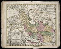
Hase, Johann Matthias, 1684-1742 Homann Erben (Firm) Homann, Johann Baptist, 1663-1724
Published / Created:
1737
Call Number:
1975 Folio 31
Collection Title:
[Atlas factice of 42 maps, produced by the Homann Erben firm]
Image Count:
1
Alternative Title:
Tabula ex novissimus ad mentem de L’Islii, inprimis vero celeberrimi geographi Dni. I.M. Hasii, Prof. Vitemb. delineata a. 1737
Publisher:
Homann Erben
Subject (Geographic):
Balkan Peninsula --Maps --Early works to 1800, Egypt --Maps --Early works to 1800, Libya --Maps --Early works to 1800, and Middle east --Maps --Early works to 1800
Uytenbogaart, J. W. H. (Johannes Wilhelmus Huybert) Wit, Frederik de., creator
Published / Created:
[1680?]
Call Number:
1973 Folio 10
Image Count:
1
Resource Type:
Maps, Atlases & Globes
Description:
Appears in the Wit's Atlas from 1680., Dedication: Amplissimo Doctissimoque Viro Domino Do. Joanni Uytenbogaert Jcto. nomine Illustrium et praepotent. DD. ordinum Hollandiae et Westvrisiae Aerary Publici Amstelodamensis Tribuno., Includes color illustrated views of Messina, Catania, and Trapano, and ancillary maps of Milazzo and Palermo., No. 21 of 69 maps bound together in composite atlas., Oriented with north toward the upper left., Relief shown pictorially., Scale indeterminable., and Urbibus praecipuis exornatum et novissime editum per F. de Wit.
Publisher:
Gedruckt tot Amsterdam by Frederik de Wit inde Kalverstraet by den Dam inde Witte Paskaert
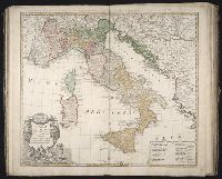
Homann Erben (Firm) L’Isle, Guillaume de, 1675-1726 Riccioli, Giovanni Battista, 1598-1671
Published / Created:
[1742?]
Call Number:
1973 Folio 30
Collection Title:
[Atlas factice of 32 maps and 1 distance table, produced by the Homann Erben firm]
Image Count:
2
Alternative Title:
Gli stati d’Italia secondo le osservationi fatte dalla Societa di Se di Parigi, dal R.P. Riccioli della S. die Giesu ed. altri astronomi, di prima geograficamente delineati ... Sgr. de l’Isle ... alle spese degl’ heredi d’Homann l’Anno MDCCXLII
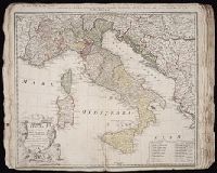
Homann Erben (Firm) L'Isle, Guillaume de, 1675-1726 Riccioli, Giovanni Battista, 1598-1671
Published / Created:
[1742?]
Call Number:
1975 Folio 31
Collection Title:
[Atlas factice of 42 maps, produced by the Homann Erben firm]
Image Count:
1
Alternative Title:
Gli stati d’Italia secondo le osservationi fatte dalla Societa di Se di Parigi, dal R.P. Riccioli della S. die Giesu ed. altri astronomi, di prima geograficamente delineati ... Sgr. de l’Isle ... alle spese degl’ heredi d’Homan[n] l’An[n]o MDCCXLII