Search
You Searched For
Search Results
- Creator:
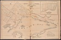
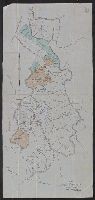
- Savigny, Hugh P
- Published / Created:
- [1870]
- Call Number:
- BrSides Double Folio 2018 101
- Image Count:
- 1
- Resource Type:
- Maps, Atlases & Globes
- Found in:
- Beinecke Rare Book and Manuscript Library > Plan of survey of the silver mining district, Thunder Bay, Lake Superior, Canada / compiled by Hugh P. Savigny, P.L.S.
- Creator:
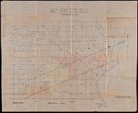
- Johnson, Thomas H., Cartographer
- Published / Created:
- 2nd Feby. 1877.
- Call Number:
- BrSides Double Folio 2018 97
- Image Count:
- 1
- Resource Type:
- Maps, Atlases & Globes
- Found in:
- Beinecke Rare Book and Manuscript Library > McIntyre / Thos. H. Johnson, Assistant Commissioner.
- Creator:
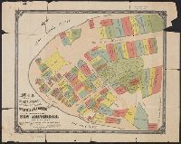
- Tyler, Henry Dunreath
- Published / Created:
- [approximately 1897?]
- Call Number:
- 771 1897A
- Container / Volume:
- BRBL_00479
- Image Count:
- 1
- Resource Type:
- Maps, Atlases & Globes
- Found in:
- Beinecke Rare Book and Manuscript Library > Map of the original grants of village lots from the Dutch West India Company to the inhabitants of New-Amsterdam (now New-York) lying below the present line of Wall Street : grants commencing A.D. 1642 / [by Henry Dunreath Tyler].
- Creator:
- De Witt, Simeon, 1756-1834
- Published / Created:
- [1793?]
- Call Number:
- 771 1793
- Container / Volume:
- BRBL_00477
- Image Count:
- 1
- Resource Type:
- Maps, Atlases & Globes
- Found in:
- Beinecke Rare Book and Manuscript Library > 1st sheet of De Witt's state-map of New-York / C. Tiebout sculp. NYork.
- Published / Created:
- 1890
- Call Number:
- 804fa P984 1890
- Container / Volume:
- BRBL_00545
- Image Count:
- 1
- Resource Type:
- Maps, Atlases & Globes
- Found in:
- Beinecke Rare Book and Manuscript Library > [East Part of Putnam County, Ohio].
- Published / Created:
- 1890
- Call Number:
- 805fa Ad18 1890
- Container / Volume:
- BRBL_00546
- Image Count:
- 1
- Resource Type:
- Maps, Atlases & Globes
- Found in:
- Beinecke Rare Book and Manuscript Library > [Map of Adams County, Indiana].
- Published / Created:
- 1936
- Call Number:
- 796 T247 1936
- Container / Volume:
- BRBL_00528
- Image Count:
- 1
- Resource Type:
- Maps, Atlases & Globes
- Found in:
- Beinecke Rare Book and Manuscript Library > Map of the city of Temple, Texas.
- Creator:
- Texas & Pacific Railway. Land Dept
- Published / Created:
- [1900?]
- Call Number:
- 796 C13 1900
- Container / Volume:
- BRBL_00527
- Image Count:
- 1
- Resource Type:
- Maps, Atlases & Globes
- Found in:
- Beinecke Rare Book and Manuscript Library > Callahan County, Texas / Office, Land Dept., Texas & Pacific Railway Co.
- Creator:
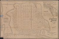
- Rand McNally and Company
- Published / Created:
- [1886?]
- Call Number:
- 844 C77 1886
- Container / Volume:
- BRBL_00604
- Image Count:
- 1
- Resource Type:
- Maps, Atlases & Globes
- Found in:
- Beinecke Rare Book and Manuscript Library > Map of Coronado Beach, San Diego, California / Rand McNally & Co., engravers, Chicago.
- Creator:
- Heyrick, J. C., creator
- Published / Created:
- 1912
- Call Number:
- 802gbc P429 1912
- Container / Volume:
- BRBL_00717
- Image Count:
- 1
- Resource Type:
- Maps, Atlases & Globes
- Found in:
- Beinecke Rare Book and Manuscript Library > Map of Riverside Coal & Timber Co. : lands on Little Leatherwood C'r, Perry Co., Kentucky / J.C. Heydrick.