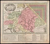
"Cum gratia et privil. S.R.I. Vicariatus, in partib[us] Rheni, Suevice, et Juris Franconici.", Covers Austria, Slovakia, Hungary, Transylvania, Slovenia and Croatia., Includes also ists of Jesuits active in the Austrian Empire., Includes table of distances given in hours of travel between individual locations., Manuscript number in upper right corner: 12. From the Karpinski-von Wieser Map Collection., and Relief shown pictorially.
Publisher:
M. Seutter
Subject (Geographic):
Europe, Central--Maps--Early works to 1800
Subject (Name):
Jesuits--Europe, Central--Maps--Early works to 1800 and Mayr, Johann Baptist, 1634-1708
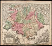
"Cum Gratia et Privil. S.R.I. Vicariatus in partibus Rheni, Sveviae et juris Franconici.", Ornamental cartouche decorated with coats of arms and mythical figures., Relief shown pictorially., and Watermark. Manuscript number in right corner: 24. From the Karpinski-von Wieser Map Collection.
Publisher:
[Mattheus Seutter]
Subject (Geographic):
France--Provence-Alpes-Côte d'Azur, Provence-Alpes-Côte d'Azur (France)--Administrative and political divisions--Maps--Early works to 1800., and Provence-Alpes-Côte d'Azur (France)--Maps--Early works to 1800.
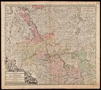
"Cu[m] gr. et pr. S.R.I. Vicariat[us], in partib[us] Rheni, Sueviae, et juris Franconici.", Appeared in Matthaeus Seutter's Atlas novus., Manuscript number in right corner: 42. From the Karpinski-von Wieser Map Collection., and Relief shown pictorially.
Publisher:
[Matthaeus Seutter]
Subject (Geographic):
Germany--Rhineland and Rhineland (Germany)--Maps--Early works to 1800.
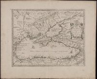
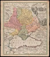
"Cum Privilegio S.C.M.", Bar scales given in wurst seu milliaria Russica, milliaria Polonica, milliaria Germanica, milliaria Gallica., Relief shown by hachures and pictorially., and Watermark. Manuscript number in upper left corner. From the Karpinski-von Wieser Map Collection.
Publisher:
[Johann Baptist Homann]
Subject (Geographic):
Black Sea--Maps--Early works to 1800., Russia--Maps--Early works to 1800., and Ukraine--Maps--Early works to 1800.
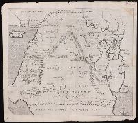
"Arabia the happie, the north part" at lower edge., From Sir Walter Raleigh's History of the world (1614)., In upper left corner: 64; in upper right corner: 65., Relief shown pictorially., Shows a portion of the Mediterranean Sea with Cyprus and Cappadocia to the northwest, the Red Sea and the Persian Sea to the south. Arabia desert and Mesopotamia near center., The map identifies the Home of Abraham at Vrocha (Chaldea), the first plantation of Chus, Babylon, Jerusalem the Garden of Eden, the City of Petra (then known to European only in legend), and the route taken by Abraham into Egypt., and Watermark.
Publisher:
[Printed by William Stansby for Walter Burre],
Subject (Geographic):
Iraq--Historical geography--Maps. and Middle East--Maps--Early works to 1800.
Subject (Name):
Raleigh, Walter, Sir, 1552?-1618. History of the world
Cuba with part of the Bahama banks & the Martyrs and The North American pilot.
Description:
From: The North American pilot. London, 1778-1779. Vol. 2, no. 13., Imperfect: chipped and torn, with no loss of text. Joined with Jeffrey's Coast of Yucatán from Campeche to Baha del Ascencion, with the west end of Cuba., Prime meridians: Ferro and London., Relief shown pictorially. Depths shown by soundings and shading., and Shows towns and roads in Cuba (except easternmost and westernmost parts) and part of Bahamas and Florida Keys.
Publisher:
Printed for Robt. Sayer,
Subject (Geographic):
Bahamas--Maps--Early works to 1800, Cuba--Maps--Early works to 1800, and Florida Keys (Fla.)--Maps--Early works to 1800
Decorated with sea monsters, mermaids, exotic animals, and cannibals, this wood cut map provides a marked contrast to the simplistic diagrams considered the earliest printed world maps. While the latter presented a world view based in Judeo-Christian theo
Alternative Title:
Typus cosmographicus universalis and Typvs cosmographicvs vniversalis
Description:
Appears in Johann Huttich's Novus orbis regionum. Basel. 1532. and Relief shown pictorially.
Publisher:
[publisher not identified],
Subject (Name):
Holbein, Hans, 1497-1543 and Huttich, Johann, 1480?-1544. Novus orbis regionum.
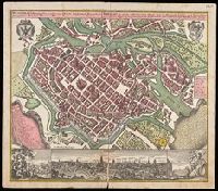
Breslau die uhralte u[nd] hochberühmte Haupt Statt des Herzogth. Schlesien auch vortrefflicher aufenthalt der Musen u[nd] florisanter Handels Plaz an dem Oder Strom
Description:
"Cum gratia et privil. S.R.I. Vicariat[us] in partib[us] Rheni, Svevice, et Juris Franconici.", Ancillary view: Breslaw. Not drawn to scale., Buildings shown pictorially., Includes index, text, and illustrations., Latin and German., and Manuscript notation in upper right corner. From the Karpinski-von Wieser Map Collection.
Publisher:
[Matthaeus Seutter]
Subject (Geographic):
Poland--Wrocław, Wrocław (Poland)--Aerial views--Early works to 1800., and Wrocław (Poland)--Maps--Early works to 1800.