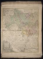
Twenty four new and accurate maps of the several parts of Europe ... : all (except the last) new
Image Count:
1
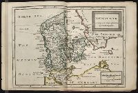
Alternative Title:
Denmark
Description:
In pencil on verso: 4.
Subject (Geographic):
Denmark --Maps --Early works to 1800
Subject (Name):
Barker, B. (Benjamin), d. 1764, bookseller, Clements, Henry, d. 1719, bookseller, King, Charles, d. 1735, bookseller, Nicholson, John, d. ca. 1717, bookseller, Parker, Richard, fl. 1692-1725, bookseller, and Tooke, Benjamin, d. 1716, bookseller
Subject (Topic):
Atlases --Early works to 1800
Collection Created:
[London] : Sold by J. Nicholson at the King’s-Arms in Little Britain, Benj. Barker and Charles King ..., Benj. Tooke ..., Hen. Clements ..., R. Parker and Ralph Smith under the Royal-Exchange ..., [1715?]
Gussefeld, F. L. (Franz Ludwig), 1744-1807 Homann Erben (Firm)
Published / Created:
1786
Call Number:
1983 Folio 23
Collection Title:
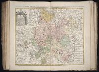
[Atlas factice of 50 maps, primarily by Johann Baptist Homann and/or issued by the Homann Erben
Image Count:
1
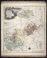
Alternative Title:
Carte geographique du Cercle de Haut-Rhin and Charte ueber die am Ober-Rhein zerstreut liegende Laender des Ober-Rheinischen Kreise
Publisher:
Bey denen Homaennischen Erben
Subject (Geographic):
Baden-Wu?rttemberg (Germany) --Maps --Early works to 1800, Hesse (Germany) --Maps --Early works to 1800, North Rhine-Westphalia (Germany) --Maps --Early works to 1800, and Rhineland-Palatinate (Germany) --Maps --Early works to 1800
Gussefeld, F. L. (Franz Ludwig), 1744-1807 Homann Erben (Firm) Schmidt, I. M.
Published / Created:
1783
Call Number:
1983 Folio 23
Collection Title:
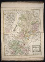
[Atlas factice of 50 maps, primarily by Johann Baptist Homann and/or issued by the Homann Erben
Image Count:
1
Alternative Title:
Carte geographique contenant le cours du Rhin, de la Meuse, & de la Moselle avec les cercles du haut- & bas-Rhin, le Duchee de Lorraine & d’Elsas & cc
Publisher:
Bey denen Homaen[n]ischen Erben
Subject (Geographic):
Germany, Southern --Maps --Early works to 1800, Hesse (Germany) --Maps --Early works to 1800, and Rhineland-Palatinate (Germany) --Maps --Early works to 1800
Gussefeld, F. L. (Franz Ludwig), 1744-1807 Homann Erben (Firm)
Published / Created:
1783
Call Number:
1983 Folio 23
Collection Title:
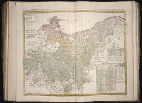
[Atlas factice of 50 maps, primarily by Johann Baptist Homann and/or issued by the Homann Erben
Image Count:
1
Alternative Title:
Circuli superioris Saxoniae pars meridionalis, Ducatum, Electoratum & Principatus Ducum Saxoniae, Princip. Anhalt. Comit. Schwarzburg, Mansfeld, Stolberg &cc
Publisher:
[Homann Erben]
Subject (Geographic):
Brandenburg (Germany) --Maps --Early works to 1800, Saxony (Germany) --Maps --Early works to 1800, Saxony-Anhalt (Germany) --Maps --Early works to 1800, and Thuringia (Germany) --Maps --Early works to 1800