Skip to search
Skip to main content
Skip to first result
Search
You Searched For
Access
Public
Genre
Engravings
Genre
Maps in books
Resource Type
Books, Journals & Pamphlets
Language
English
New Search
Search Results
Creator:
Published / Created:
1791 March
Call Number:
DU170 H85+ Oversize
Collection Title:
An historical journal of the transactions at Port Jackson and Norfolk island, with the discoveries
Image Count:
1
Resource Type:
Books, Journals & Pamphlets
Subject (Geographic):
New South Wales --History
Subject (Name):
Ball, Henry Lidgbird, King, Philip Gidley, 1758-1808, and Phillip, Arthur, 1738-1814
Collection Created:
London : J. Stockdale, 1793
Found in:
Beinecke Rare Book and Manuscript Library > A map of all those parts of the territory of New South Wales which have been seen by any person belonging to the settlement established at Port Jackson, in the said territory ...
Creator:
Published / Created:
1775 September
Call Number:
A89 P384
Collection Title:
The Pennsylvania magazine: or, American monthly museum
Image Count:
1
Resource Type:
Books, Journals & Pamphlets
Description:
Verso blank.
Subject (Name):
Paine, Thomas, 1737-1809
Collection Created:
Philadelphia, Printed and sold by R. Aitken [1775-1776]
Found in:
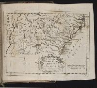
Beinecke Rare Book and Manuscript Library > A new map of North & South Carolina, & Georgia
Call Number:
Ik P810 +Z745
Collection Title:
A plan of Mr. Pope’s garden : as it was left at his death, with a plan and perspective view of the
Image Count:
1
Resource Type:
Books, Journals & Pamphlets
Subject (Name):
Pope, Alexander, 1688-1744, Pope, Alexander, 1688-1744 --Homes and haunts, and Pope, Alexander, 1688-1744 Verses on the grotto at Twickenham
Collection Created:
London, Printed for R. Dodsley, at Tully’s Head in Pall-Mall; and sold by M. Cooper in Pater-noster-Row, 1745
Found in:
Beinecke Rare Book and Manuscript Library > A plan of Mr. Pope's garden as it was left at his death
Call Number:
1978 +73
Collection Title:
The ecclesiastical history of New-England from its first planting in the year 1620 unto the year of
Image Count:
1
Resource Type:
Books, Journals & Pamphlets
Description:
Verso blank.
Subject (Geographic):
New England --Biography, New England --Church history, and New England --History --Colonial period, ca. 1600-1775
Collection Created:
London, Printed for Thomas Parkhurst, at the Bible and Three Crowns in Cheapside, 1702
Found in:
Beinecke Rare Book and Manuscript Library > An exact mapp of New England and New York
Creator:
Published / Created:
1739
Call Number:
1996 +91
Image Count:
3
Resource Type:
Books, Journals & Pamphlets
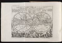
Description:
"A continuation ... brought down to the present year 1738 ..." v. 3, p. [649]-784., Frontispiece map, 25 x 41 cm., Imperfect: map opposite p. 425, v.3 wanting., and Map: A plan of Fort St. George and the City of Madras, 25 x 22 cm.
Publisher:
Printed for Messrs. Bettesworth and Hitch; J. Clarke; S. Birt; Tho. Wotton, and J. Shuckburgh; and T. Osborne,
Subject (Geographic):
Madras (India)--Maps--Early works to 1800 and World maps--Early works to 1800
Subject (Name):
Aurangzeb, Emperor of Hindustan, 1618-1707 --Portraits
Subject (Topic):
Geography--Early works to 1800
Found in:
Beinecke Rare Book and Manuscript Library > Modern history: or, The present state of all nations. Describing their respective situations, persons, habits, ... animals and minerals. ... By Mr. Salmon. Illustrated with cuts and maps ... by Herman Moll ...
Creator:
Published / Created:
ann. 1605.
Call Number:
1976 Folio 46
Image Count:
125
Resource Type:
Books, Journals & Pamphlets
Alternative Title:
Mariners mirrour.
Description:
Charts and title pages in English, text in Dutch., Map oriented with North at bottom left., and Volvelle on p. [17].
Publisher:
Jodocus Hondius excudit,
Subject (Geographic):
Europe --Maps --Early works to 1800, Great Britain --Maps --Early works to 1800, Netherlands --Maps --Early works to 1800, and North Sea --Maps --Early works to 1800
Found in:
Beinecke Rare Book and Manuscript Library > The mariners mirrovr wherin may playnly be seen the courses, heights, distances, depths, sounding, flouds and ebs, risings of lands, rocks ... of the harbouroughs, havens and ports of the greatest part of Europe: ... together w.th the rules and instrumeíÄ
Branch:v1.61.8 ,Deployed:2024-06-20T11:15:15-04:00