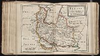
Twenty four new and accurate maps of the several parts of Europe ... : all (except the last) new
Image Count:
1
Alternative Title:
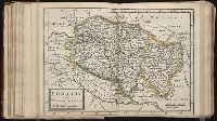
Hungary, Transilvania, &c
Description:
In pencil on verso: 23. and Table of contents for maps 20-24 misnumbered.
Subject (Geographic):
Hungary --Maps --Early works to 1800 and Transylvania (Romania) --Maps --Early works to 1800
Subject (Name):
Barker, B. (Benjamin), d. 1764, bookseller, Clements, Henry, d. 1719, bookseller, King, Charles, d. 1735, bookseller, Nicholson, John, d. ca. 1717, bookseller, Parker, Richard, fl. 1692-1725, bookseller, and Tooke, Benjamin, d. 1716, bookseller
Subject (Topic):
Atlases --Early works to 1800
Collection Created:
[London] : Sold by J. Nicholson at the King’s-Arms in Little Britain, Benj. Barker and Charles King ..., Benj. Tooke ..., Hen. Clements ..., R. Parker and Ralph Smith under the Royal-Exchange ..., [1715?]
Forty-two new maps of Asia, Africa, and America ... : all engrav’d, according to the latest
Image Count:
1
Alternative Title:
Japan, Niphon, &c, New Guinea, New Britain, and New Holland &c, and New Guinea,&c. This is joyn'd to Japan, Niphon, &c. being two maps in one plate
Description:
In ink on verso: 12.
Subject (Geographic):
Australia --Maps --Early works to 1800, Japan --Maps --Early works to 1800, New Britain Island (Papua New Guinea) --Maps, and New Guinea --Maps --To 1800
Twenty four new and accurate maps of the several parts of Europe ... : all (except the last) new
Image Count:
1
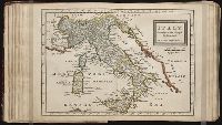
Alternative Title:
Italy in general, with Naples, the Isle of Sicily, &c
Description:
In pencil on verso: 19.
Subject (Geographic):
Italy --Maps --Early works to 1800, Naples (Italy) --Maps --Early works to 1800, and Sicily (Italy) --Maps --Early works to 1800
Subject (Name):
Barker, B. (Benjamin), d. 1764, bookseller, Clements, Henry, d. 1719, bookseller, King, Charles, d. 1735, bookseller, Nicholson, John, d. ca. 1717, bookseller, Parker, Richard, fl. 1692-1725, bookseller, and Tooke, Benjamin, d. 1716, bookseller
Subject (Topic):
Atlases --Early works to 1800
Collection Created:
[London] : Sold by J. Nicholson at the King’s-Arms in Little Britain, Benj. Barker and Charles King ..., Benj. Tooke ..., Hen. Clements ..., R. Parker and Ralph Smith under the Royal-Exchange ..., [1715?]
The map shows the Klamath River and Cottonwood Creek Mining district in Siskiyou County, California, Hornbook and Klamath City, and indicates the routes of the Yreka and Ashland stage road and the California and Oregon Railroad. Scale, 2inches = 1 mile.
Subject (Name):
California and Oregon Railroad Company --Maps and Siskiyou County (Calif.) --Maps
Subject (Topic):
Gold mines and mining--California, Northern--Maps, Gold mines and mining--California--Klamath River, and Gold mines and mining--California--Siskiyou County
George Chorpenning (1820-1894) operated mail service in western states during the 1850s. Beginning in 1857, he petitioned the United States government for compensation and recovery of business losses, a claim that remained unresolved at his death in 1894., Imperfect: map mutilated with some loss of image and text., and Verso linen backed and blank.
Subject (Geographic):
United States--Politics and government--1865-1900
Subject (Name):
United States.--Post Office Dept and United States.--Postmaster General
Subject (Topic):
Letter carriers--West (U.S.) and Postal service--West (U.S.)
Forty-two new maps of Asia, Africa, and America ... : all engrav’d, according to the latest
Image Count:
1
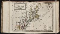
Alternative Title:
New England, New York, New Jersey, and Pensilvania
Description:
In pencil on verso: 39. and Table of contents for maps 2-20 in section "America" misnumbered.
Subject (Geographic):
New England --Maps --Early works to 1800, New Jersey --Maps --Early works to 1800, New York (State) --Maps --Early works to 1800, and Pennsylvania --Maps --Early works to 1800