Forty-two new maps of Asia, Africa, and America ... : all engrav’d, according to the latest
Image Count:
1
Alternative Title:
A chart of the coasts of Peru, &c
Description:
In pencil on verso: 29. and Table of contents for maps 2-20 in section "America" misnumbered.
Subject (Geographic):
Darien (Panama and Colombia) --Early works to 1800, Peru --Maps --Early works to 1800, Popayan (Colombia), Quito (Ecuador) --Maps, and South America --Maps --Early works to 1800
Forty-two new maps of Asia, Africa, and America ... : all engrav’d, according to the latest
Image Count:
1
Alternative Title:
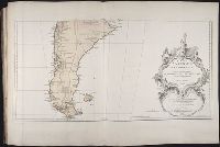
Chili, Patagonia, part of La Plata &c
Description:
In pencil on verso: 27. and Table of contents for maps 2-20 in section "America" misnumbered.
Subject (Geographic):
Chile --Maps --Early works to 1800, Patagonia (Argentina and Chile) --Maps --Early works to 1800, South America --Maps --Early works to 1800, and Tierra del Fuego (Argentina and Chile)
Forty-two new maps of Asia, Africa, and America ... : all engrav’d, according to the latest
Image Count:
1
Alternative Title:
Peru, and the country of the Amazons
Description:
In pencil on verso: 28. and Table of contents for maps 2-20 in section "America" misnumbered.
Subject (Geographic):
Amazon River Region --Maps --Early works to 1800, La Plata (Argentina) --Maps, Peru --Maps --Early works to 1800, and South America --Maps --Early works to 1800
Anville, Jean Baptiste Bourguignon d', 1697-1782 Kitchin, Thomas, d. 1784 Sayer, Robert, 1725-1794, creator
Published / Created:
1787 July 1
Call Number:
1982 Folio 10
Image Count:
2
Description:
Also appeared in Kitchin's General atlas describing the whole universe. London : Printed for Robert Sayer, [1780]., Includes descriptive notes and text "Division of South America with a summary account of its trade," and large ornamental cartouche., Inset map: Chart of the Falkland's Islands : named by the French Malouine Islands, and discovered by Hawkins in the year 1595. Scale [ca. 1:2,000,000]., No. 43 of 43 maps bound together in composite atlas., Prime meridian: Ferro., Relief shown pictorially; depths by soundings., Scale [ca. 1:7,900,000]., and Sheets mounted together to form 2 sheets.
Publisher:
Printed for Robert Sayer
Subject (Geographic):
Falkland Islands --Maps --Early works to 1800 and South America --Maps --Early works to 1800
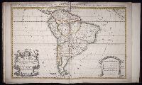
Anville, Jean Baptiste Bourguignon d', 1697-1782 Haye, G. de la
Published / Created:
avec privilege 1748
Call Number:
2003 Folio 85
Image Count:
1
Description:
Hand colored., 2003 Folio 85: No. 43 of 45 maps bound together with binder’s spine title: Atlas of America, Bookplate: Robinson. Bookplate of Paul Mellon, Relief shown pictorially., and Scale [ca. 1:2,500,000]
South America divided into its pricipall parts, viz. the Firm-land, Peru, Chili ... described by Sanson, corrected and amended by William Berry
Description:
Bar scales given in Italian miles, common leagues of France, common leagues of Spain, common leagues of Germany, and common English miles., Dedicated to Charles II by William Berry., No. 69 of 69 maps bound together in composite atlas., Prime meridian: Ferro., Relief shown pictorially., and Scale [ca. 1:16 000 000].
Publisher:
Sold by William Berry at the sign of the Globe between Charing-Cross and White-Hall