1. A map of America, between latitudes 40 and 70 north and longitudes 45 and 180 west, exhibiting Published / Created: 1801 Call Number: Zc90 801mab Collection Title: Voyages from Montreal, on the river St. Laurence, through the continent of North America, to the Image Count: 1 Found in: Beinecke Rare Book and Manuscript Library > A map of America, between latitudes 40 and 70 north and longitudes 45 and 180 west, exhibiting Mackenzie's track from Montreal to Fort Chipewyan & from thence to the North Sea In 1789 & to the West Pacific Ocean in 1793
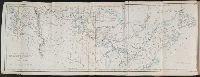
2. Map to illustrate Mr. Kane's travels in the territory of the Hudson's Bay Company Creator: Weller, Edward, d. 1884 Call Number: Zc90 859ka Collection Title: Wanderings of an artist among the Indians of North America : from Canada to Vancouver's Island and Image Count: 1 Found in: Beinecke Rare Book and Manuscript Library > Map to illustrate Mr. Kane's travels in the territory of the Hudson's Bay Company