Skip to search
Skip to main content
Skip to first result
Search
You Searched For
Genre
Manuscript maps
Resource Type
Maps, Atlases & Globes
Language
Dutch; Flemish
New Search
Search Results
Published / Created:
[ca. 1725]
Call Number:
6555cea 1725
Container / Volume:
BRBL_00708
Image Count:
1
Resource Type:
Maps, Atlases & Globes
Description:
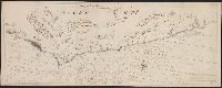
Color: Pen and ink drawing.
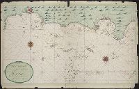
Subject (Geographic):
Ghana--Maps, Manuscript--Early works to 1800
Found in:
Beinecke Rare Book and Manuscript Library > Goud Kust.
Published / Created:
c1640]
Call Number:
3365 1640
Container / Volume:
BRBL_00701
Image Count:
1
Resource Type:
Maps, Atlases & Globes
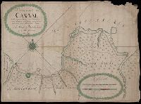
Description:
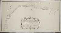
Accompanied by letter dated 10/9/1984 from the Algemeen Rijksarchief., Index giving names of 4 forts., Pictorial ills. of towns., and Upper right corner: 59.
Subject (Geographic):
Brabant (Belgium)--Maps--Early works to 1800
Found in:
Beinecke Rare Book and Manuscript Library > T'fort aende Warande [cartographic material].
Published / Created:
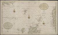
[1683?]
Call Number:
23 1683
Container / Volume:
BRBL_00700
Image Count:
1
Resource Type:
Maps, Atlases & Globes
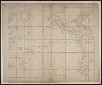
Description:
Apparently a manuscript copy of the Robijn map of approximately the same title. Cf. Phillips, v. 1 no. 493. and Color: Red and green, black lettering.
Publisher:
J. Robyn,
Subject (Geographic):
Islands of the Pacific--Maps, Manuscript--Early works to 1800
Found in:
Beinecke Rare Book and Manuscript Library > Wassende graadt kaert vande Groote Zud Zee.
Branch:v1.61.6 ,Deployed:2024-06-12T09:55:33-04:00