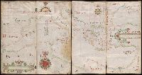
"Made by Nicholas Comberford dwelling neare to the way end of the school house at the signe of the Platt in Radcliffe, anno 1647.", Contains two and a half compass roses and four listings of indexed names., Decoration: city views with banners., Pen-and-ink in black, red, blue, green, yellow and gold., Portolan chart with seaport names given for all coastlines., Scale "containeth one hundreth English leagues after twentie to a degree.", and Title devised by cataloger.
Subject (Geographic):
Black Sea--Maps--Early works to 1800. and Mediterranean Sea--Maps--Early works to 1800.
Subject (Topic):
Nautical charts--Black Sea--Early works to 1800. and Nautical charts--Mediterranean Sea--Early works to 1800.