Search
You Searched For
Search Results
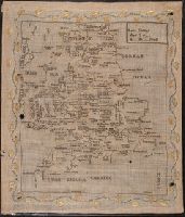
- Creator:
- Giddings, Amelia
- Published / Created:
- 1815
- Call Number:
- BrSides Double Folio 2019 3
- Image Count:
- 2
- Resource Type:
- Maps, Atlases & Globes
- Found in:
- Beinecke Rare Book and Manuscript Library > Map of England / Amelia Giddings aged 9 years.
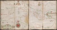
- Creator:
- Comberford, Nicholas, -1673, cartographer.
- Published / Created:
- [1647]
- Call Number:
- 49 1647
- Image Count:
- 2
- Resource Type:
- Maps, Atlases & Globes
- Found in:
- Beinecke Rare Book and Manuscript Library > Portolan chart of the Mediterranean Sea, the Black Sea, and the northern coast of Africa.
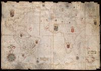
- Creator:
- Albernaz, João Teixeira, active 1665-1681
- Published / Created:
- [1665]
- Call Number:
- 11 1665
- Image Count:
- 2
- Resource Type:
- Maps, Atlases & Globes
- Found in:
- Beinecke Rare Book and Manuscript Library > Portolan chart of the Atlantic, the western half of the Indian Ocean, and the extreme southeast of the Pacific.
- Published / Created:
- [ca. 1789]
- Call Number:
- 6555cea 1789
- Container / Volume:
- BRBL_00708
- Image Count:
- 3
- Resource Type:
- Maps, Atlases & Globes
- Found in:
- Beinecke Rare Book and Manuscript Library > A New Survey of that part of the Coast of Africa comprised between Cape Verga and Cape Formoso, including chiefly the Windward and Gold Coasts in which the Latitudes of all the Principal Places are determined by Actual observations, the bearings and cours
- Published / Created:
- 1824
- Call Number:
- 761 B41 1824
- Container / Volume:
- BRBL_00710
- Image Count:
- 3
- Resource Type:
- Maps, Atlases & Globes
- Found in:
- Beinecke Rare Book and Manuscript Library > [Manuscript map of part of Belfast, Maine by George Watson].
- Published / Created:
- [after 1811]
- Call Number:
- BrSides Folio 2018 123
- Image Count:
- 3
- Resource Type:
- Maps, Atlases & Globes
- Found in:
- Beinecke Rare Book and Manuscript Library > [Manuscript map of a portion of Veracruz-Llave in Mexico].
- Published / Created:
- 1953?]
- Call Number:
- 11hcf 1919A-4
- Container / Volume:
- BRBL_00010N
- Image Count:
- 1
- Resource Type:
- Maps, Atlases & Globes
- Found in:
- Beinecke Rare Book and Manuscript Library > Small sketch map of Poland probably drawn by R.J. Kerner to illustrate hastily proposed Czech-Jugoslav Corridor.
- Published / Created:
- 1919?]
- Call Number:
- 11hcf 1919C-1-2
- Container / Volume:
- BRBL_00010S
- Image Count:
- 1
- Resource Type:
- Maps, Atlases & Globes
- Found in:
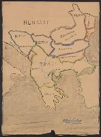
- Beinecke Rare Book and Manuscript Library > [Manuscript Map of the Balkan Peninsula].
- Published / Created:
- 1919?]
- Call Number:
- 11hcf 1919C-1-3
- Container / Volume:
- BRBL_00010S
- Image Count:
- 1
- Resource Type:
- Maps, Atlases & Globes
- Found in:
- Beinecke Rare Book and Manuscript Library > [Manuscript map of the Balkan Peninsula].
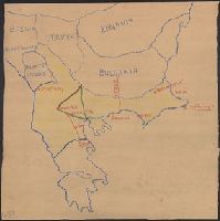
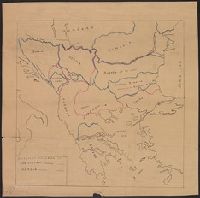
- Published / Created:
- 1878?]
- Call Number:
- 11hcf 1919C-1-1
- Container / Volume:
- BRBL_00010S
- Image Count:
- 1
- Resource Type:
- Maps, Atlases & Globes
- Found in:
- Beinecke Rare Book and Manuscript Library > [Manuscript Map showing boundaries according to the Treaty of Berlin and the Treaty of San Stefano].